


How parcel data helps you find property lines at scale
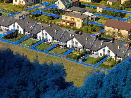
Parcel data provides mapped property boundaries and information about individual parcels of land. Businesses and government agencies use it to understand where properties are located, how land is divided, what’s on each parcel, and how properties relate to surrounding infrastructure and geographic features.
Because parcel data is managed across thousands of jurisdictions, acquiring and maintaining it at scale can be difficult. Schemas, update schedules, and publishing standards often vary by source.
This article explains what parcel data is, what parcel datasets contain, how parcel boundaries represent property lines, and how organizations use this information for mapping, property research, planning, site selection, and other location-based workflows.
Smarty provides parcel boundary and property data at an enterprise scale. Test a sample, request a custom dataset, start a 42-day free trial of property data, or keep reading to learn more.
Here’s what you can expect to learn about parcel data:
- What is parcel data?
- How parcel data helps identify property lines
- What information is included in parcel datasets?
- How parcel data is used across industries
- Challenges of sourcing parcel data at scale
- What to look for in a parcel data provider
- Conclusion: Parcel data makes land mapping scalable
- Parcel data FAQ
What is parcel data?
Parcel data is geographic and descriptive information about individual parcels of land. It typically includes mapped parcel boundaries, identifiers, and property-related attributes such as addresses, acreage, land use, zoning, and building information.
A parcel is an individual unit of land represented within a cadastral system (public land record). In geographic information systems, or GIS, parcels are typically represented as polygons that show the mapped shape and location of the land.
The outer edge of each polygon is called a parcel boundary. The outer edge of each polygon represents a mapped parcel boundary. These boundaries are sometimes informally called parcel lines or property lines, although mapped parcel boundaries shouldn’t be treated as a legal determination of a property line.
Parcel data plays an important role in land mapping by providing a structured geographic representation of individual properties. Instead of working only with street addresses or coordinates, organizations can see the physical footprint of each parcel.
Parcel data vs. property data
Parcel data and property data are closely related, but they’re not exactly the same.
Parcel data primarily focuses on land and its geographic representation. It may answer questions such as:
- Where is the parcel located?
- What are its mapped parcel boundaries?
- How large is the lot?
- Which parcels are adjacent?
- What identifier (like a PUID) is associated with the land?
- What land-use or zoning classifications apply?
Property data provides broader information about the property. This can include the structures, financial characteristics, assessments, ownership-related records, and other attributes associated with the location.
A simple way to think about the difference is this: Parcel data shows where the property is and how the land is shaped. Property data explains what exists there and the characteristics associated with it.
Modern property intelligence datasets often bring both together, combining parcel geometry with standardized property attributes in a single schema.
How parcel data helps identify property lines

One of the primary uses of parcel data is to visualize and analyze the mapped boundaries between properties.
In a GIS environment, each parcel is represented as a geographic polygon. The edges of that polygon form the parcel boundary, allowing analysts to see where one mapped parcel ends and another begins.
This makes parcel data especially useful for organizations that need to evaluate property boundaries across many locations.
A typical land mapping workflow might look like this:
- Start with an address, coordinate, or parcel identifier.
- Match the location to the appropriate parcel data record.
- Display the parcel boundary in GIS software.
- Compare the parcel with neighboring parcels or other geographic layers.
- Analyze how infrastructure, zoning, hazards, structures, or other features relate to the property.
With parcel data, GIS teams can perform this analysis across large datasets instead of researching one parcel at a time.
For example, a telecommunications company might use parcel boundaries to determine which properties sit near a planned fiber route. A real estate developer might use parcel data to identify lots that meet acreage requirements. A utility company might compare parcel boundaries with existing infrastructure to plan service expansion.
Parcel boundaries are not legal surveys
Although parcel data is useful for land mapping and property analysis, a mapped parcel boundary should not generally be treated as the final legal determination of a property line.
Parcel geometry is compiled from government and land-record sources and is designed for mapping, analysis, planning, and reference. Legal property boundaries may depend on deeds, plats, legal descriptions, survey monuments, field measurements, and other evidence.
When the exact legal location of a boundary matters, a professional land survey may be necessary.
Parcel data is therefore best understood as a scalable way to visualize and analyze mapped parcel boundaries, rather than a replacement for legal surveying.
What information is included in parcel datasets?
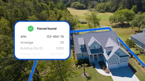
Parcel datasets usually combine parcel geometry with descriptive information about the land and property.
The geometry shows the parcel’s mapped shape and location, enabling visualization of parcel boundaries, comparison of neighboring properties, and spatial analysis in GIS.
Depending on the source, parcel data may also include:
- Parcel identifiers: APNs, parcel IDs, or other jurisdiction-specific numbers used to distinguish individual parcels.
- Site addresses: The physical or situs address associated with the parcel, when available.
- Acreage and lot characteristics: Details such as lot size, acreage, dimensions, or parcel type.
- Land-use and zoning classifications: Information about how the land is currently used and, where available, how it is zoned.
- Building or improvement attributes: Details about structures on the parcel, such as building type, square footage, or number of improvements.
- Assessment and other property metadata: Additional information such as assessed values, jurisdictional details, tax-related fields, or other locally maintained records.
The challenge is that these attributes can vary widely from one jurisdiction to another. Field names, classifications, formats, and available information are rarely identical across counties.
Modern parcel datasets reduce that complexity by combining parcel geometry and property attributes into a standardized schema, making it easier to analyze land consistently across larger geographic areas. For example, Smarty’s US Parcel Boundary Data comes with 110+ standardized parcel attributes for fast categorization and analysis.
How parcel data is used across industries
Parcel data is useful wherever an organization needs to understand land, properties, infrastructure, or geographic relationships in detail.
Because parcel boundaries define the mapped footprint of individual properties, they can provide a useful geographic foundation for many business and government workflows.
Real estate

Real estate organizations use parcel data to understand properties individually and analyze broader markets.
Common applications include:
- Site selection: Parcel data can help identify properties that meet requirements for acreage, location, land use, or development potential.
- Property research: Real estate teams can use parcel boundaries and property attributes to better understand a location's characteristics before acquisition or investment.
- Development planning: Parcel data can be combined with zoning, infrastructure, road networks, environmental layers, and neighboring parcels to evaluate development opportunities.
- Market analysis: Analysts can compare parcel sizes, land-use classifications, development patterns, and property characteristics across a market.
- Valuation support: Parcel information can complement sales, assessment, structure, and market data used in property valuation workflows.
In these use cases, parcel data provides a geographic layer that helps organizations treat property as more than an address in a database.
Utilities and telecommunications

Utilities and telecommunications providers often need to understand how physical properties relate to infrastructure networks.
Parcel data can help connect those two views.
- Infrastructure planning: Teams can compare parcel boundaries with roads, utility lines, rights-of-way, and other infrastructure.
- Fiber deployment: Telecommunications providers can identify parcels near planned or existing fiber routes and evaluate potential service areas.
- Utility expansion: Electric, gas, water, and other utility providers can analyze parcel data when planning network extensions or new service.
- Service territory analysis: Parcel boundaries can help identify which properties fall within or near defined service areas.
- Asset planning: Organizations can compare land mapping data with infrastructure assets to support construction, maintenance, expansion, and long-term investment.
Parcel data effectively creates a geographic bridge between network infrastructure and the properties that infrastructure serves.
P&C insurance
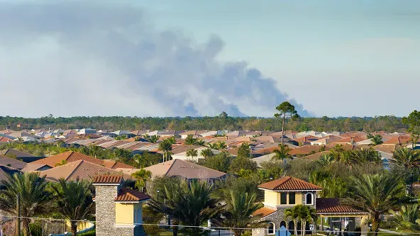
Property and casualty insurers use parcel data to understand the physical context surrounding the properties they insure. While an address or geocode identifies a location, parcel boundaries can show the full extent and context of the property and help insurers evaluate what actually exists and how it exists at that location.
Common applications include:
- Underwriting: Parcel boundaries and property attributes can provide additional context about lot size, land use, property type, and other characteristics that may influence risk.
- Structure identification: Insurers can use parcel data to determine whether multiple structures are located on a property, such as detached garages, workshops, barns, sheds, or agricultural buildings, which may introduce additional exposure.
- Hazard analysis: Parcel boundaries can be compared with wildfire zones, floodplains, coastlines, vegetation, and other hazard data to better understand how much of a property may be exposed.
- Accumulation and concentration analysis: Insurers can analyze parcels alongside neighboring properties and insured locations to better understand geographic risk concentrations.
- Claims investigation: Following a loss, parcel information can provide geographic context around the insured property and help teams evaluate structures, boundaries, and surrounding land.
- Portfolio analysis: Carriers can combine parcel data with policy, property, hazard, and claims information to identify patterns and evaluate risk across a book of business.
For P&C insurers, parcel data adds another layer of property intelligence beyond a single address or point on a map, helping teams build a more complete picture of the location and exposures they’re evaluating.
Challenges of sourcing parcel data at scale
Parcel data is often created and maintained by local governments.
That decentralized model can make nationwide land mapping difficult.
If an organization needs parcel data for only one county, it may be able to obtain the information directly from a local assessor or GIS department. But when that same organization needs parcel boundaries across hundreds or thousands of jurisdictions, the workload grows exponentially.
County-by-county data collection: Parcel information may be published by counties, cities, assessors, GIS departments, or other agencies. Organizations building their own parcel database may need to locate, download, and manage data from thousands of individual sources.
Inconsistent schemas: Jurisdictions often use different field names, classifications, parcel identifiers, and data structures. One source may label acreage one way while another uses a completely different field structure. Land-use classifications, zoning information, addresses, and parcel IDs may also vary. Before those datasets can be analyzed together, they have to be normalized.
Different update schedules: Parcel data isn’t static. Land can be subdivided, combined, developed, reassessed, reclassified, and renumbered. Different jurisdictions may publish updates on different schedules, making it difficult to maintain a consistently current national dataset.
Data normalization requirements: Collecting parcel geometry is only the beginning. Organizations also have to reconcile attribute names, land-use classifications, parcel identifiers, address formats, coordinate systems, file formats, and geometry structures. Without normalization, parcel data from multiple jurisdictions can be difficult to compare or analyze consistently.
All of these factors are complicated enough on their own, but then timing also comes into play.
A parcel database requires continual maintenance.
Source websites may change. Files may move. Schemas may be updated. Parcel boundaries may change. Street addresses and property lines may shift. New records may appear, and old ones may disappear.
At scale, parcel data management becomes an ongoing data-engineering operation rather than a one-time collection project.
This ongoing burden of sourcing, normalization, and maintenance is why organizations increasingly seek statewide or nationwide parcel data products that consolidate and standardize information across many jurisdictions.
What to look for in a parcel data provider
A good parcel data provider should make it easier to use parcel information consistently across your existing systems and workflows.
| What to look for | Why it matters |
| Geographic coverage | Make sure the dataset covers the states, regions, or nationwide footprint your organization needs. |
| Data quality | Look for clean parcel geometry, reliable attributes, and quality-control processes. |
| Update frequency | Parcel data changes as land is subdivided, combined, developed, or reassessed, so regular updates matter. We recommend a provider who updates quarterly. |
| Standardized attributes | Consistent field names and classifications make parcel data easier to analyze across jurisdictions. |
| GIS compatibility | The data should work easily with the mapping, spatial analysis, and database tools your teams already use. An API compatible platform is usually the simplest implementation method. |
| Available formats | Choose delivery formats that fit your technical environment and reduce unnecessary conversion work. |
| Integration capabilities | Parcel data is more useful when it can connect with addresses, structure locations, property attributes, and other location intelligence. |
Smarty’s US Parcel Boundary Data provides state and nationwide coverage, standardized parcel attributes, and multiple delivery formats.
SmartyKey® can help connect parcel and address records with a persistent unique identifier, and this is included across all Smarty products.
US Rooftop Geocoding adds precise building locations for workflows that need to understand where a structure sits on a parcel.
Conclusion: Parcel data makes land mapping scalable
Parcel data gives organizations a practical way to understand individual properties across large geographic areas.
Instead of researching parcel boundaries one county or property at a time, businesses can use standardized parcel data to map, filter, compare, and analyze properties at scale.
That can support better decisions in real estate, utilities, telecommunications, infrastructure planning, development, and any other industry that needs to understand the physical relationships among land, properties, and geographic features.
Modern parcel datasets also reduce the operational work required to collect, normalize, and maintain records from thousands of local jurisdictions.
For organizations that need reliable land mapping across large areas, parcel data provides the foundation for understanding:
- Where a property is
- What land belongs to it
- How that property relates to the world around it
Explore US Parcel Boundary Data by requesting a sample file generation or custom sample to see how standardized parcel boundaries, SmartyKey®, and rooftop geocoding can strengthen your location intelligence workflows.
Parcel data FAQ
How accurate is parcel data?
Parcel data is generally useful for mapping, research, planning, and spatial analysis, but accuracy can vary by source and jurisdiction. It should not replace a professional land survey when exact legal boundaries are required.
How often is parcel data updated?
Update frequency varies by jurisdiction and provider. Parcels can change through subdivisions, combinations, development, reassessment, and other land-record updates, so regularly refreshed data is important.
Can you match an address to parcel data?
Yes. An address can be matched to parcel data to identify the parcel associated with that location. This can help connect address records with parcel boundaries and other property information.
Who uses parcel data?
Parcel data is used by real estate, utilities, telecommunications, insurance, government, construction, finance, logistics, and other organizations that need to understand properties and land at scale.
Why use nationwide parcel data instead of county parcel maps?
Nationwide parcel data provides organizations with a standardized way to analyze properties across jurisdictions without having to individually source, format, and maintain parcel records from each county or local agency.
Was this helpful?