


P&C reinsurance risk modeling: Why data accuracy determines outcomes
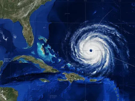
P&C reinsurance risk modeling depends on accurate location data, including verified, geocoded, and enriched addresses, to produce reliable outcomes for underwriting, catastrophe modeling, and portfolio management. However, many P&C reinsurers rely on inaccurate address data and map that data with imprecise geocodes, assuming they’re “good enough.”
To improve their address data quality and access accurate location data, property and casualty reinsurance companies implement:
- Address verification: Validate, normalize, and standardize addresses, then attach a persistent, unique identifier to each delivery point.
- Address enrichment: Enrich verified addresses from submission data with structural, location, and financial property attributes, including elevation, county, roof material, and construction type.
- Rooftop-level geocoding: Pinpoint the precise latitude and longitude coordinates of a structure, whether that’s the building’s rooftop or an exact sub-unit in a multi-unit structure.
With risk models that rely on verified addresses, rooftop-level geocodes, and reinsurance data enrichment, P&C reinsurers can:
- Assess risk with confidence: With precise property locations, extensive property characteristics, and parcel information, P&C reinsurers can better evaluate a property’s location and its associated risk.
- Streamline facultative underwriting and treaty negotiation: Risk assessments built on accurate, enriched reinsurance data help P&C reinsurers understand existing exposures and determine whether to assume that risk for a cedent under a treaty or policy.
- Create efficient, automated workflows: When geocodes and property data points are appended or pre-appended to asset addresses, reinsurance teams can avoid manual data collection and focus on complex treaties or policies.
Start testing these tools now, or keep reading to learn how P&C reinsurers verify and enrich submission data to enable smarter risk modeling.
In this article, we’ll cover:
- What is reinsurance data enrichment?
- Why P&C reinsurance data quality is the starting point for reinsurance exposure data
- How poor location data corrupts P&C reinsurance risk models upstream
- Must-have capabilities for P&C reinsurance data quality
- Why Smarty is built for P&C reinsurance data accuracy
- FAQ
What is reinsurance data enrichment?
For P&C facultative and treaty reinsurers, reinsurance data enrichment involves appending third-party information (e.g., rooftop-level geocodes, parcel boundaries, and property characteristics) to submission data received from cedents, brokers, and other providers.
Reinsurance data enrichment provides reinsurers with more complete exposure data, improving risk modeling and enabling more informed underwriting decisions about treaties and facultative P&C reinsurance policies.
With reinsurance data enrichment, you can improve:
P&C reinsurance risk modeling: With rooftop-level geocodes and property catastrophe risk data, you can measure the distance between an insured structure’s exact coordinates and hazards like tornado zones, wildfire perimeters, flood zones, bodies of water, and high-crime areas.
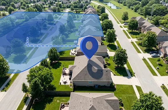
- Exposure management: During facultative underwriting or treaty negotiation, you decide how much risk you’ll assume for a cedent. Reinsurance data enrichment helps you identify and understand existing exposures, then determine whether to cover or exclude them under your treaty or policy.
- Efficiency and speed: Reinsurance data enrichment APIs can automatically append data to incoming P&C reinsurance submissions or ceding terms. That reduces manual research, as well as the errors and data gaps that come with it.
- Automated data pipelines: P&C reinsurance data enrichment can power automated underwriting workflows that use machine learning or artificial intelligence. Straightforward properties or portfolios can be automatically evaluated to determine whether they fit a reinsurer’s appetite.
Why P&C reinsurance data quality is the starting point for reinsurance exposure data
For P&C reinsurers, exposure data refers to the location, property, financial, and insurance information used to estimate potential losses. Treaty P&C reinsurers use exposure data to evaluate portfolios, while facultative P&C reinsurance underwriters use it to underwrite individual risks.
Because those risks are often catastrophic or unusual, it’s especially important for underwriters to rely on high-quality exposure data. Otherwise, incorrect or incomplete exposure data can distort risk models, leading to misjudged risk exposure and inaccurately priced policies.
However, many P&C reinsurers know their data is inaccurate or incomplete and choose to live with it. For these companies, bad data is like a bad roommate. It leaves dirty socks by the couch, refuses to do the dishes, and generally makes life harder, yet everyone puts up with it to keep the peace.
But you don’t have to keep living with bad data.
You can use reinsurance data enrichment to add rooftop-level geocodes, property characteristics, parcel boundaries, and business information to the submission data you receive from cedents, brokers, and other providers.
Before reinsurance data enrichment can work effectively, the address data it relies on needs to be verified.
That’s why Smarty’s US Address Verification serves as a starting point for P&C reinsurance exposure data. US Address Verification ensures that addresses are valid, standardized, complete, and up to date before data enrichment.
To do that, US Address Verification matches each address against a database of USPS, non-USPS, new-build, and provisional addresses, and prioritizes high match accuracy over high match rates.
Some address verification APIs are built to match every submitted address, including addresses that don’t exist. Those APIs can return a match for partial addresses, but they can’t guarantee the match is correct. When inferred address components are used to force matches, false positives can slip through the cracks.
By prioritizing match accuracy, US Address Verification avoids false positives. If there isn’t a match for an address, or if minor changes are made to an address in order to obtain a match, the API will let you know.
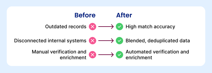
At no extra configuration or cost, US Address Verification returns verified addresses with up to 55 points of metadata covering location, deliverability, and structural data, along with a persistent, unique identifier called SmartyKey®, which can be used to reliably deduplicate and blend reinsurance data.
In addition to preventing forced matches and providing address metadata, US Address Verification prevents misspellings, mismatched city and ZIP Code, missing secondaries, and other address errors that could link an address to the wrong third-party data or to no data at all.
With a foundation of clean, enriched address data and accurate insurance data, property and casualty reinsurance underwriters can better determine exposures and underwrite risk.
How poor location data corrupts P&C reinsurance risk models upstream
Address verification is an important starting point for accurate risk models and P&C reinsurance data enrichment, but it’s only one piece of location data.
Geocodes—the latitude and longitude coordinates of a specific location—are also key location data points. By enriching verified addresses with rooftop-level geocodes, property and casualty reinsurance underwriters can identify exact structure locations.
However, not all geocodes have the same level of precision. Some providers offer:
- ZIP9-level geocodes: ZIP+4 Codes refer to a specific delivery route, meaning the path a delivery truck travels in a single drop-off. ZIP+4-level geocodes use those codes to approximate the latitude and longitude point that corresponds to that delivery route, making them cost-effective for big-picture, large-scale analysis that doesn’t need high precision.
- Interpolated geocodes: Using known geocodes, interpolated geocodes estimate the locations of properties along a street segment. Like ZIP9-level geocodes, interpolated geocodes are cost-effective but offer low precision.
- Parcel-centroid geocodes: Using parcel boundaries, parcel-centroid geocodes locate the center of a property. For large or irregularly-shaped parcels, that center can be hundreds of feet from a property’s actual location. So, while more parcel-specific than ZIP9-level and interpolated geocodes, parcel-centroid geocodes still only estimate a property’s location.
- Rooftop-level geocodes: Rooftop-level geocodes identify the exact location of the primary structure on a parcel, providing the precision level you need to model risk accurately.
Relying on parcel-centroid geocodes rather than rooftop-level geocodes in risk modeling can introduce errors that corrupt property and casualty reinsurance risk models upstream.
A parcel-centroid geocode may indicate that a property is hundreds of feet away from a wildfire zone, flood boundary, coastline, or other potential risks, even though the property is much closer. As a result, an underwriter may over- or underestimate the property’s exposure.
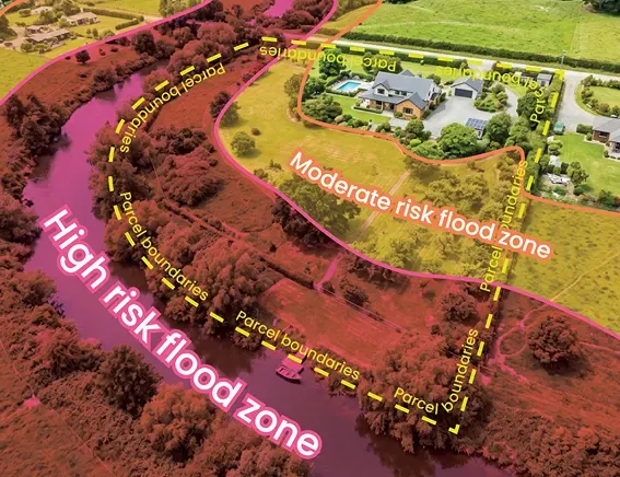
Across a large portfolio, those errors can compound, and loss ratios can enter a financially unsustainable range.
However, when P&C reinsurance risk modeling relies on rooftop-level geocodes, reinsurers can better estimate risk and keep sustainable loss ratios.
In addition to imprecise geocodes, invalid addresses and inaccurate property data can cause future issues for property and casualty reinsurance risk models. That’s why you need tools that accurately verify, enrich, and geocode addresses from submission data at scale.
Must-have capabilities for P&C reinsurance data quality
Address validation, rooftop-level geocoding, and address data enrichment are must-have capabilities for improving P&C reinsurance data quality. Together, they help reinsurers identify the property they’re evaluating, pinpoint its location, and access additional geospatial data needed for risk modeling.
Here’s what to look for in each location data solution.
Address verification
P&C reinsurers use address verification to correctly format, validate, and normalize property addresses across internal systems from data entry. Look for address verification tools that can help you:
- Create a foundation for reinsurance data enrichment: Different providers verify addresses against databases with varying coverage. An address verification solution that validates addresses against a comprehensive database of USPS, non-USPS, and provisional addresses improves match rates before reinsurance data enrichment.
- Prevent duplicate records: Some providers will assign a persistent, unique identifier (PUID) to each verified address. Because PUIDs remain constant, even when an address changes, you can use them to easily find duplicate records and either merge or eliminate them.
- Connect treaty or facultative reinsurance policy data across teams: PUIDs also enable you to easily match reinsurance data across underwriting, exposure management, claims, and catastrophe modeling teams.
- Map properties alongside hazard zones: You can map current and potential insured properties to visualize and analyze large-scale exposure. If you use a mapping platform, it’s worth confirming that your provider doesn’t prohibit customers from mapping verified address data on third-party platforms.
Geocoding
Once an address is verified, geocoding can identify the address’s exact coordinates. Look for solutions that return rooftop-level geocodes, which help you improve:
- Catastrophe risk modeling: Rooftop-level geocodes can be used to quickly measure the distance between a structure and a nearby fuel load, a vegetation burn point, a flood zone, a storm zone, a body of water, or other climate-related risk factors.
- Hazard exposure evaluation: Some providers offer rooftop-level geocoding solutions that can distinguish between units within a multi-unit building and pinpoint the roof of a structure on a large, rural parcel. That helps you evaluate risk exposure for specific units rather than for entire multi-building lots, multi-family housing residences, resort properties, or other large complexes.
- Portfolio management: You can use rooftop-level geocodes to identify properties for monitoring, modeling, and analysis when evaluating portfolio performance and creating strategies to improve profitability and growth.
Address enrichment
When P&C reinsurers enrich addresses from submission data with third-party data, they can append or pre-append property characteristics to verified addresses to better understand the risk associated with a property. When evaluating providers, you’ll want coverage for:
- Structural attributes: From square footage and construction type to year built and roof finish material, a wide coverage of structural attributes enables you to create comprehensive risk assessments.
- Location attributes: Location attributes include latitude and longitude coordinates, elevation, acreage, and other data points that you can use to build more accurate models for wildfire, flood, storm, and crime risk.
- Parcel attributes: Data points like parcel boundaries, acreage, and total market value streamline risk assessments for large, irregularly shaped properties, allowing you to avoid county-by-county sourcing.
Why Smarty is built for P&C reinsurance data accuracy
With the right location data solution, you can access accurate, comprehensive exposure data for P&C reinsurance risk modeling, exposure management, underwriting, and automated workflows. When verified addresses serve as the foundation for rooftop-level geocodes and reinsurance data enrichment, treaty P&C reinsurers can better evaluate portfolios, and facultative P&C reinsurance underwriters can better assess individual properties’ risk.
If you’re evaluating a location data provider, look for broad address database coverage, PUIDs, mapping platform compatibility, secondary address level geocoding, and property data that includes location, structural, and financial attributes.
Smarty’s suite of address data solutions brings those capabilities together in one place. Smarty’s verifies addresses against a database of over 193 million USPS addresses and 20 million non-USPS addresses, geocodes addresses down to the secondary level, and enriches addresses with up to 350 property data points.
Sign up for a 42-day free trial of Smarty’s address verification, rooftop-level geocoding, and property data tools to see what accurate location data can do for your P&C reinsurance workflows.
FAQ
What is data enrichment in insurance?
In the insurance industry, data enrichment is the process of appending third-party information to existing data to improve P&C insurance data accuracy and create a more complete view of a property’s risk.
What is an example of data enrichment?
With Smarty’s US Property Data API, you can enrich an address from submission data and append up to 350 location, structural, and demographic data points to that address, including its elevation, county, square footage, roof material, and total market value.
What are the 4 types of reinsurance?
Four main types of reinsurance include:
What is data enrichment?
In general, the data enrichment process attaches third-party data to known data to improve business intelligence.
Was this helpful?