
Underwriting prefill for P&C insurance
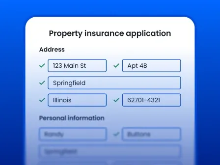


Underwriting prefill uses verified third-party data to automatically complete portions of a P&C insurance application or risk profile. Instead of relying entirely on applicants or agents to enter property information manually, insurers and reinsurers can use verified addresses to retrieve location, parcel, and property data, enabling faster quotes, faster time-to-value, and more confident underwriting decisions.
While speeding up the underwriting process by asking fewer questions of your clients is a plus, the bigger win comes from knowing that the data that fills those fields describes the right property.
If your underwriting starts with pre-filling an app, you're already behind the eight ball.
Smarty provides address verification, rooftop geocoding, property data, and parcel data layers that P&C insurers can integrate within existing quoting systems, rating engines, underwriting software, CRMs, and insurance data-processing workflows. Every product is tied to a persistent, unique identifier, so even when using multiple products or even multiple vendors, your teams can pre-append forms with ease and pinpoint accuracy.
You don't have to take our word for it. Sign up for a 42-day free trial, check out our P&C solutions page, or continue reading to learn more about underwriting prefill and other P&C insurance solutions.
Table of contents
- What is an underwriting prefill?
- Why bad data slows down the P&C underwriting process
- How underwriting prefill works for P&C insurance
- How Smarty powers underwriting solutions for P&C insurance
- How better location data supports reinsurance underwriting workflows
- Underwriting prefill success stories for P&C carriers
- What to look for in an underwriting prefill data provider
- Why leading P&C carriers choose Smarty for underwriting data quality
- Conclusion: Faster underwriting starts with better data
- Frequently asked questions
- How does prefill speed up the underwriting process?
- What data is typically prefilled in insurance underwriting?
- Is underwriting prefill only for P&C insurance?
- How does address verification support underwriting prefill?
- How does geocoding improve the P&C underwriting process?
- Can Smarty replace an underwriting system?
What is an underwriting prefill?
Underwriting prefill in P&C insurance is the process of automatically retrieving trusted information about an applicant, address, property, or risk and using it to populate underwriting fields for internally or externally facing insurance industry forms. It can reduce manual data entry, accelerate quoting, improve data consistency, and provide underwriters with more complete information before they review a submission.
Instead of asking an applicant or agent to manually provide every available property characteristic, an insurer or reinsurer can start with a limited amount of information—often a verified address—and use connected data sources to build out the risk profile.
Depending on the insurer and line of business, underwriting prefill can support several stages of the P&C insurance underwriting process, including:
- Intake: Reduce the number of fields applicants or agents need to complete manually.
- Quoting: Retrieve relevant property and location information earlier in the workflow.
- Underwriting review: Provide underwriters with cleaner, more complete inputs to evaluate a risk, all connected with a PUID.
- Bind: Reduce last-minute corrections caused by inconsistent information.
- Renewal: Refresh or compare property and location information as policies return for review.
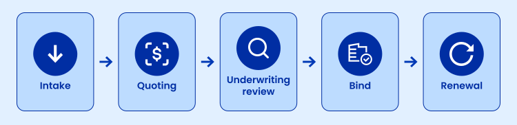
The key is that prefill should make the insurance underwriting process easier without replacing appropriate underwriting judgment.
Verified data vs. self-reported data
Applicant-provided information is useful, but people don’t always know the answers to underwriting questions or how to format them to avoid data management issues such as duplicate records.
A homeowner may know approximately when the house was built, but not its exact construction details. They may know the roof material type but not the parcel size, the building's square footage recorded by local governments, the structure's elevation, or the structure's precise latitude and longitude.
Even something as seemingly straightforward as an address can contain a typo, missing directionals (North, South, etc.), an incorrect ZIP Code, an outdated street name, or ambiguous secondary information.
Underwriting prefill shifts more of the data-collection burden away from applicants and agents by automatically retrieving information that can be verified through trusted sources. It provides insurers and reinsurers with another source of valid, standardized information to work from.
But the order of operations matters: validate the location first, then enrich it.
Correcting an address after property data has already been retrieved creates additional work and slows down underwriting. Validating and standardizing the address at entry gives downstream insurance underwriting tools a cleaner starting point.
Why bad data slows down the P&C underwriting process
Many underwriting bottlenecks look like workflow problems. More often than most insurers and reinsurers realize, they’re data problems:
- An underwriter has to stop and investigate when an application is incomplete.
- An agent may need to contact the insured again.
- Operations staff may re-key information from one system into another.
- Property attributes may conflict between sources.
- A low-precision geocode may place a risk somewhere near the property without identifying the structure itself.
Individually, those issues may add only a little friction. At the P&C scale, they can become a significant obstacle to efficient underwriting.
Manual entry creates more opportunities for inconsistency
Insurance industry applications ask for a lot of information. Some forms we’ve seen span multiple pages before any additional property, liability, auto, or other coverage-specific sections are added.
Every field entered manually creates another opportunity for a typo, an abbreviation discrepancy, a formatting difference, or an incomplete value. And those inconsistencies can create a bigger problem than one incorrect record; they can make the same risk look like two different risks.
For example, one system might contain:
125 N Main St
while another contains:
125 North Main Street
If those records aren’t standardized and connected, they may be treated as separate accounts. One underwriter could research the property, verify its characteristics, gather supplemental data, and complete a review without realizing that another underwriter is doing the same work using a slightly different address. Did somebody say fraud?
The problem extends to enrichment as well.
Property data found and attached to one version of the address doesn’t automatically carry over to another record if the two accounts haven’t been recognized as the same location.
That can lead to duplicated research and inconsistent assessments, but the bigger concern is that critical risk data may be attached to only one version of the address. An underwriter reviewing the second record could then be working from an incomplete risk profile, potentially underestimating the property’s exposure or insuring more risk than the carrier realizes.
Underwriting prefill helps reduce these problems by pairing address validation with property data. Once the location is verified and standardized, insurers and reinsurers can use that trusted address to retrieve and prefill relevant property details, reducing manual entry while giving underwriters a more complete and consistent application from the start. That stronger foundation can carry across quoting, underwriting, renewals, and other downstream systems.
That means fewer chances to introduce differences in the first place—and a better chance that work completed for one property remains connected to that property throughout the insurance workflow.
A property record isn’t useful if it belongs to the wrong property
Imagine an applicant enters an inaccurate or incomplete address. A property-data provider may still return a plausible match.
The result can look complete: square footage, parcel characteristics, construction attributes, valuation information, and other fields are all present.
But completeness often doesn’t equal accuracy.
If those attributes describe the house next door, another building on the parcel, or an entirely different unit, the insurer has enriched the wrong risk.
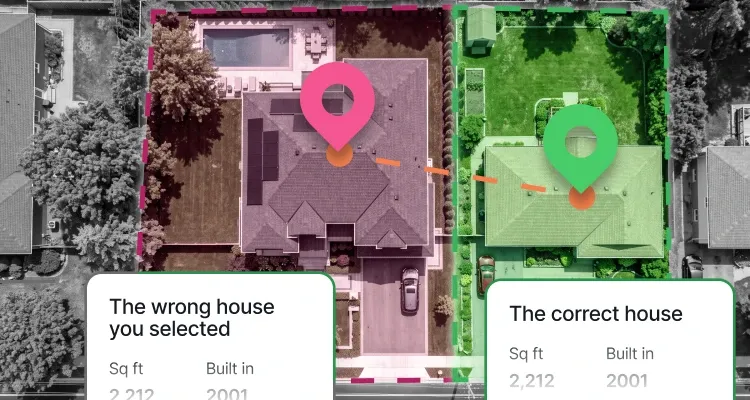
That can affect downstream decisions involving rating, hazard data, catastrophe modeling and exposure, territory assignment, portfolio analysis, actuarial modeling, and underwriting review.
Over time, those inaccuracies can also distort assumptions about insurance pricing, claim frequency, and claim severity, ultimately affecting a carrier’s loss ratio.
Accurate addresses tied to a persistent, unique identifier are the keys that connect risk to the location intelligence that follows.
Low-precision geocoding can introduce another layer of uncertainty
A standardized address tells you which location you’re working with. Geocoding tells you where that location is.
For P&C insurance, the distinction between a ZIP-level or street-level approximation and the coordinates of the actual structure can matter when other datasets are highly location-dependent. Consider the areas that can all depend on knowing where the insured structure is located on a parcel, or even on different floor levels in a multi-unit tower:
- Wildfire exposure
- Flood characteristics
- Storm surge exposure
- Severe weather patterns
- Earthquake and fault-zone exposure
- Crime rates
- Terrain and elevation
- Proximity to fire protection resources
- Building-to-building proximity
- Catastrophe models
More precise locations provide insurers with stronger insights into how local hazards may influence expected claim frequency and, ultimately, the loss ratio of a book of business.
Smarty's US Rooftop Geocoding is designed to pinpoint a structure or parcel to the unit level, rather than relying on broader geographic centroids, enabling insurers to build risk profiles with more precise location data details.
Fragmented data creates more reconciliation work
Insurers often depend on multiple sources for applicant, property, geospatial, hazard, claims, and third-party information. That isn’t inherently a problem; different providers specialize in different datasets.
The problems arise when those sources don’t share a reliable way to identify the same location. Without standardized location data, teams have to determine whether records from aggregated sources describe the same exposure before they can confidently combine them.
Verifying and standardizing the address data they receive from third-party vendors can help create a common reference point, making it easier to match external data to the correct property or account.
For insurers and reinsurers operating under Solvency II, consistent, accurate, and appropriately managed data also supports broader regulatory expectations around risk management, technical provisions, and reporting quality.
Better address and location data give those systems a more consistent foundation for connecting records across underwriting systems, CRMs, rating engines, claims platforms, and third-party data sources.
How underwriting prefill works for P&C insurance
The exact process of underwriting in insurance varies by carrier, product, and risk, but the data-prefill portion can be surprisingly straightforward and similar.
A practical P&C underwriting prefill workflow looks like this:
| Step | Description | |
|---|---|---|
| 1 | Applicant enters an address | The applicant, agent, or existing system provides the initial property address. |
| 2 | Address is validated and standardized | The address is checked against authoritative and trusted address information, corrected where appropriate, and returned in a consistent format. |
| 3 | A verified location record is created | The quoting or underwriting system receives the normalized address and associated location identifiers or metadata. |
| 4 | The correct structure or parcel is geocoded | Precise coordinates establish the physical location of the insured structure or property. |
| 5 | Property and parcel attributes are appended | Available characteristics can be retrieved for the verified location, rather than relying exclusively on the applicant's entry. |
| 6 | Data flows into existing P&C insurance software | The information can feed a quoting platform, rating engine, underwriting system, CRM, analytical environment, or other insurance data-processing workflow. |
| 7 | The underwriter reviews a cleaner risk profile | Instead of beginning with an incomplete submission and manually researching every detail, the underwriter has a more complete starting point and can focus on where human review adds the most value. |
The outcome is faster quotes, less manual data entry, and stronger risk-location confidence.
How Smarty powers underwriting solutions for P&C insurance
Although Smarty is not an underwriting platform, rating engine, or replacement for an insurer’s existing P&C insurance software, we provide the address and property intelligence layer that those systems can use.
This design allows carriers and insurtech teams to incorporate location intelligence into the workflows and insurance underwriting technology they already use, rather than rebuilding their technology stack around another underwriting application.
US Address Verification: Establish the correct risk location first
US Address Verification validates, corrects, and standardizes an entered address before other underwriting information depends on it.
That creates a stronger first step for underwriting prefill.
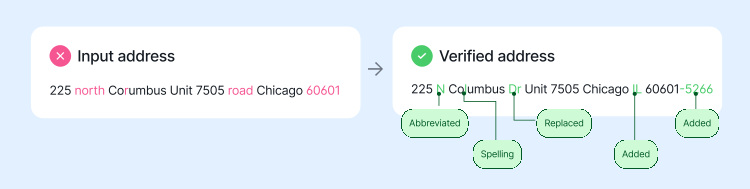
If the input is incomplete, misspelled, improperly formatted, or otherwise questionable, the workflow can address the problem before attempting to attach detailed property information to a file or client.
Smarty also supports single-address, bulk, and API-based verification workflows, allowing address quality to be incorporated at intake or applied to existing datasets.
TL;DR underwriting benefit: Cleaner inputs reduce the chance of building an otherwise detailed underwriting profile around the wrong location.
US Rooftop Geocoding
A verified mailing address and a precise physical location answer different questions.
US Rooftop Geocoding converts a verified address into geocoordinates associated with the structure or parcel and reports the precision level returned.
That gives P&C insurers a more precise location and confidence level of that geocode for connecting downstream hazard and risk information.
TL;DR underwriting benefit: Greater confidence that location-sensitive risk data is being evaluated against the intended structure accurately.
US Property Data
Once the location is established, US Property Data can add available property characteristics to the record.
Smarty provides more than 350 attributes across categories such as location, structure, parcel, valuation, tax, and property-sale information.
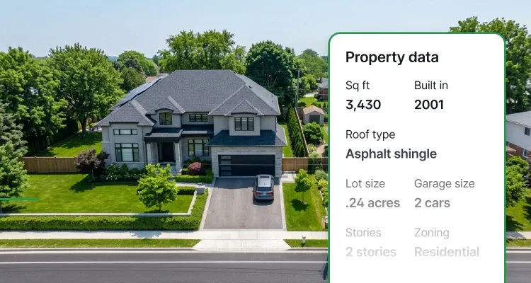
Those fields can supplement applicant-provided information, support automated review workflows, and provide carriers with more complete input for insurance pricing, risk segmentation, and underwriting decisions.
TL;DR underwriting benefit: Less manual property research and a more complete set of inputs for the insurer’s existing underwriting process.
US Parcel Boundary Data
The structure isn’t always the whole story.
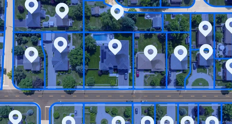
US Parcel Boundary Data provides normalized parcel boundaries and standardized parcel attributes for geospatial analysis. Smarty's current dataset includes parcel geometry and 110+ parcel attributes, including details such as the number of structures associated with a parcel.
That context can reveal exposure that may not be obvious from the primary structure alone. A property submitted as a single-family home, for example, may also include a mechanic shop, barn, chicken coop, milk house, or other structures that introduce additional risk. Understanding what else exists on the parcel can help underwriters identify potential exposure gaps and evaluate the property more completely.
TL;DR underwriting benefit: A clearer picture of the full property exposure, not just the primary structure or a single point on a map.
Batch and API workflows
Underwriting data quality should be good at entry, but it’s important to note that a deep clean of existing policy records can also be highly beneficial for workflows surrounding renewals, data migration between systems, and portfolio standardization before analysis.
Real-time APIs can support applicant and agent workflows as an address is submitted, while batch processing supports cleaning and maintaining larger existing datasets.
For development and insurtech teams evaluating insurance industry solutions, the goal is to integrate high-quality location data into the tools you’re already using.
Because one location can connect multiple datasets, standardization also makes it easier to connect information across systems.
Here’s a table to sum up how each Smarty tool serves the insurance underwriting process:
| Smarty product | What it does | Why it matters for underwriting prefill | Underwriting benefit |
|---|---|---|---|
| US Address Verification | Validates, corrects, and standardizes entered addresses through single-address, bulk, or API-based workflows. | Gives insurers a clean, verified address before any downstream enrichment takes place. This helps prevent a property, parcel, or risk model from being attached to the wrong location. | Cleaner inputs reduce the chance of building a detailed underwriting profile around the wrong risk location. |
| US Rooftop Geocoding | Converts a verified address into coordinates tied to the correct structure or parcel and returns the precision level. | Helps insurers identify the actual location of the insured property, enabling more accurate connections to hazard, catastrophe, and other location-sensitive data. | Greater confidence that the location-based risk model is tied to the intended structure. |
| US Property Data | Appends 350+ property attributes across categories such as location, structure, parcel, valuation, tax, and sale data. | Helps prefill relevant property characteristics so underwriters do not have to manually research or re-enter as much information. | Less manual property research and a more complete set of underwriting inputs. |
| US Parcel Boundary Data | Provides normalized parcel boundaries, parcel geometry, and 110+ standardized parcel attributes for spatial analysis. | Adds parcel-level context that helps insurers understand how a structure relates to the land around it and to other spatial datasets. | A clearer geographic picture of the property beyond a single point on a map. |
How better location data supports reinsurance underwriting workflows
The same data-quality principle extends beyond primary property and casualty underwriting.
A reinsurance underwriting system depends on exposure information received from carriers, brokers, modeling environments, and portfolio systems. When location records are inconsistent or imprecise, reinsurers may need to perform additional work before exposures can be analyzed consistently.
That data quality becomes even more important for European insurers and reinsurers subject to Solvency II, where exposure and portfolio information must be reliable enough to support risk-based supervision, technical provisions, and regulatory reporting.
Address standardization can make location records easier to compare. Precise geocoding can improve confidence in the geographic location of exposures. Property and parcel information can add additional context for risk modeling.
Cleaner exposure data can also support analyses of historical burning cost, helping reinsurers compare past losses with the exposures and locations that generated them.
The purpose isn’t to replace catastrophe models or reinsurance underwriting tools, or even underwriters. It's to give your teams cleaner location inputs to make more accurate decisions.
For a deeper discussion of this relationship, read more about location intelligence for insurance.
Underwriting prefill success stories for P&C carriers
Cytora provides a digital risk processing platform used in insurance workflows. Its collaboration with Smarty integrates Smarty's US Property Data—including hundreds of attributes plus address and geospatial information—into Cytora's platform.
Smarty doesn’t need to become the underwriting platform. Instead, an underwriting platform can use Smarty as a specialized data layer, retrieving cleaner property and location information inside the workflow insurers already use.
Behind the scenes, before an underwriter has to research or re-enter the information manually, that’s where underwriting prefill creates the most value.
What to look for in an underwriting prefill data provider
Not every insurance underwriting tool needs to provide every function. In fact, specialized providers are often most useful when they integrate cleanly with the rest of the underwriting ecosystem.
When evaluating a provider for an underwriting prefill workflow, consider:
| What to look for | Why it matters for underwriting prefill | |
|---|---|---|
| Address validation quality | Look for USPS CASS-certified validation, Delivery Point Validation (DPV), standardization, correction, and clear deliverability indicators—not just fuzzy address matching. *Smarty also returns up to 55 address metadata points and a persistent, unique SmartyKey® identifier with your address validation subscription. | Underwriting enrichment should begin with a verified location. If the address is wrong or ambiguous, the property and risk modeling data appended afterward can link to and describe the wrong structure. Verifying first means everything that comes after is reliable information. |
| Rooftop/parcel geocoding coverage | The API should tell you what precision level was actually returned, such as rooftop, parcel, or ZIP9, not just provide latitude and longitude with no context. Furthermore, look for a provider that can quantify how often they reach true rooftop-level or parcel-level precision. Smarty reports 97% of U.S. addresses geocoded to the rooftop or parcel level. | For hazard and property underwriting, ZIP or street centroids may be too broad—especially in rural areas and dense urban environments. Rooftop-level precision helps underwriters confirm whether a coordinate represents the actual structure, a parcel center, or a broader area, improving confidence that the risk model data is tied to the intended property. |
| Property data breadth | Look for hundreds of usable property attributes, not a small handful of basic assessor fields. Smarty currently documents over 350 attributes: 63 location, 139 financial, and 154 structural attributes. | Broader coverage can reduce manual research and support more complete prefill across construction, valuation, parcel, location, and property characteristics. |
| Parcel data depth | Look for actual parcel geometry plus standardized parcel attributes. Smarty provides 110+ parcel attributes and parcel geometry across a dataset covering 210M+ addresses. | A point coordinate cannot always explain how the structure relates to the surrounding land. Parcel geometry supports spatial analysis and more detailed hazard modeling. |
| Persistent location identification | Look for a persistent identifier that survives formatting or address changes. SmartyKey® is designed to associate records with the same address even when elements such as street name, city, or ZIP Code change. | Persistent IDs make it easier to deduplicate accounts and keep every enrichment and hazard layer attached to the same risk and the same property instead of repeating research for multiple versions of one address. |
| API response time | For real-time quoting, look for documented performance targets in the hundreds of milliseconds. Smarty’s US Street Address API SLA targets responses within 500 ms. | Prefill should shorten quote workflows, not introduce noticeable delays while applicants or agents wait for third-party data. |
| API availability | Look for a contractual SLA rather than a vague reliability claim. Smarty’s broader service currently reports over 99.999% average historical uptime. | Address validation may sit at the beginning of the quote workflow. If that service is unavailable, everything downstream can stall. |
| Processing scale | Look for both real-time APIs and bulk processing with documented throughput. Smarty documents plans starting at 25,000 US address lookups per second, with capabilities of going even faster if needed, and supports single, bulk, and API workflows. | Carriers may need the same data layer for one quote today and millions of policy or renewal records tomorrow. The underwriting prefill solution you choose should be able to keep up, no matter your scale. |
| Data freshness | Ask for a published refresh cadence, especially for property and parcel datasets. Smarty offers parcel data with quarterly or yearly update cadences, depending on the delivery arrangement. | Even highly accurate property data loses value if it does not reflect recent construction, sales, parcel changes, or assessor updates. |
Why leading P&C carriers choose Smarty for underwriting data quality
Smarty offers a lot when it comes to underwriting prefill and address data tools. Many modern P&C carriers go with Smarty over other competitors like EasyPost, PostGrid, Google, Precisely, and Melissa for many reasons, including:
- Highly accurate, verified address data
- Rooftop-level geocoding
- Extensive property and parcel enrichment
- Real-time APIs and batch processing
- Developer-friendly implementation
- Accessible, enterprise, human support
- Reduced manual review
- Faster quote and bind workflows
- Improved risk-location confidence
- Stronger downstream insurance data processing
- Better applicant, agent, and underwriter workflows
Evaluation criteria
So, what makes a good underwriting prefill solution? Property and casualty insurers should evaluate more than how many fields a provider can populate. The strongest solutions help establish the correct risk location, return enough information to evaluate it, make the quality of that information clear, and perform reliably at an insurance scale.
Here’s what to look for.
Accuracy and location confidence
Address validation accuracy and transparency
A high match rate means little if a provider achieves it by aggressively changing the submitted address until something matches. That can create a false positive: a seemingly valid result associated with the wrong property.
Look for validation that not only corrects and standardizes addresses, but also explains what changed and why. Smarty's address component analysis, for example, identifies changes to individual address components and indicates whether each one was confirmed, unconfirmed, or missing.
Geocoding precision
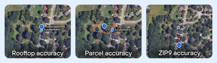
Underwriters should be able to tell whether geocoding coordinates represent the actual rooftop, the center of a parcel, or a broader ZIP-level area.
That distinction matters when small location differences can affect wildfire exposure, flood characteristics, elevation, neighboring structures, coastal exposure, and other risk modeling factors. Smarty's US Rooftop Geocoding returns precision indicators such as rooftop, parcel, and ZIP9 so teams know what kind of result they’re working with.
Persistent location identity
A strong prefill workflow should recognize the same property when its address appears differently across systems or changes over time. Otherwise, duplicate records can lead to duplicate enrichment, research, and underwriting work.
Look for a persistent, unique identifier instead of relying entirely on address-string matching. SmartyKey® is a persistent identifier assigned by Smarty to every address, helping insurers connect records, identify aliases, and reduce duplicate work across datasets.
Enrichment depth and risk model context
Property data coverage
Property prefill should provide enough information to meaningfully reduce applicant questions and underwriter research. Look beyond a few basic assessor fields and evaluate both the number and usefulness of available attributes.
Smarty's US Property Data currently includes hundreds of location, financial, and structural attributes, including fields such as year built, building square footage, roof information, construction characteristics, elevation, assessed value, tax information, and prior-sale information.
While the goal isn't to prefill every available field, having enough breadth to support your underwriting guidelines, routing rules, products, and risk models can only increase productivity and accuracy across any underwriting workflow.
Parcel-level context
A rooftop coordinate identifies a structure, but some underwriting questions require understanding the surrounding land as well.
Look for parcel geometry and standardized attributes that help answer questions about parcel size, land use, multiple structures, boundaries, and nearby exposures. Smarty's US Parcel Boundary Data adds that spatial context beyond a single point on a map.
Data freshness
Addresses, structures, ownership records, parcels, and property characteristics all change over time. New construction appears, parcels are split, streets are renamed, and buildings are renovated, damaged, demolished, or rebuilt.
Ask providers how often each dataset is refreshed rather than accepting a general claim that their data is current. Underwriters should also be able to see relevant dates, precision indicators, or metadata so they know when a result may require additional review.
Workflow performance and scalability
Real-time API performance and uptime
Prefill should speed up quoting; applicant- and agent-facing workflows often depend on address and property data while users are actively waiting for results.
Look for providers who publish contractual response-time and availability targets rather than simply calling their APIs “fast.”
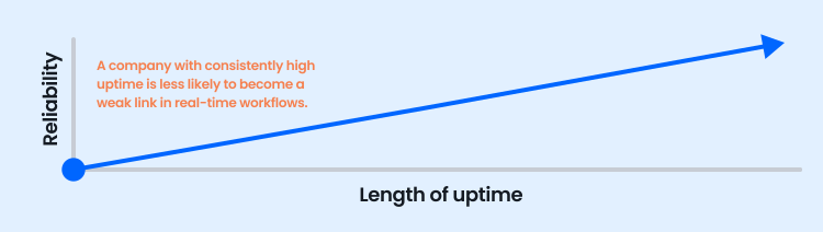
Also evaluate the provider’s broader historical uptime, not just a single API’s SLA. A company with consistently high uptime is less likely to become a weak link in quoting, automated decisioning, agent tools, and other real-time underwriting workflows.
Batch processing and throughput
Real-time lookups are only one part of the insurance use case. Carriers may also need to enrich existing books, prepare renewal records, clean data during migrations, deduplicate policies, or assess portfolios before catastrophe modeling.
Evaluate both API rate limits and bulk-processing capabilities. The same provider should be able to support one quote now and millions of records later without forcing teams into a separate workflow.
Integration and developer experience
The best data isn't useful if implementation becomes a long-running IT project. Look for clear, cloud-capable API documentation, SDKs, sample code, testing environments, tutorials, implementation guidance, and knowledgeable human support.
Also consider how easily the provider’s datasets work together. A verified address should lead naturally to its geocode, property record, parcel, and other enrichment without requiring developers to build new matching logic between every dataset.
For insurers modernizing P&C insurance solutions, that makes it easier to incorporate prefill into existing quoting systems, rating engines, CRMs, underwriting platforms, and analytics environments.
Governance, security, and decision transparency
Data transparency and auditability
Underwriters need enough context to know whether to trust the answers that address data can provide.
A prefill provider for insurance should expose signals such as match quality, address-component changes, geocode precision, missing information, and other indicators of uncertainty. Just as importantly, providers should be willing to return a no-match when the submitted address cannot be confidently tied to a known location. A no-match is often more useful than a forced or questionable match because it gives underwriters a clear signal that the record needs further review rather than quietly attaching risk modeling data to a potentially wrong property.
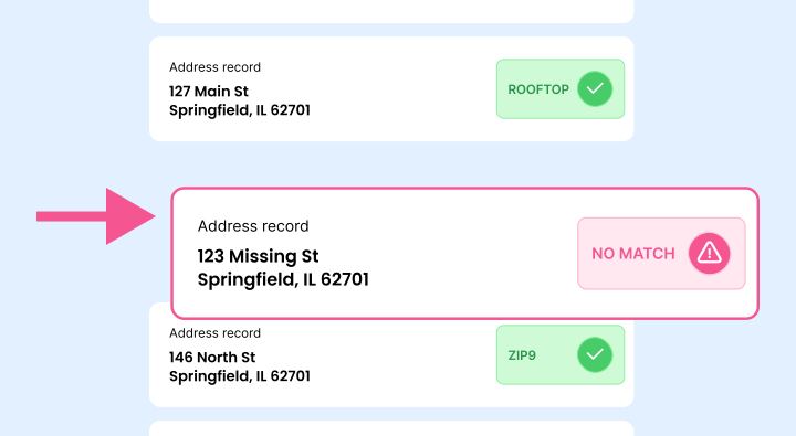
Those signals can support business rules that automatically process high-confidence results while routing ambiguous or unmatched records for manual review. That makes prefill useful for populating fields as well as for triaging submissions and focusing underwriter attention where it matters most.
Privacy, security, and regulatory compliance
Insurance systems can handle sensitive customer and business information, so evaluate what the provider receives, retains, protects, and makes accessible.
For organizations subject to Solvency II, that evaluation should also assess whether external data can be traced, documented, and quality-assessed, since the framework places explicit emphasis on complete, accurate, appropriate, and transparently processed data.
Look for independently assessed security controls, encryption, clear retention practices, incident-response procedures, and appropriate enterprise agreements. Teams should also be able to understand and audit returned data rather than treating enrichment as an opaque third-party decision.
Support and accountability
Finally, evaluate what happens when something goes wrong. Underwriting workflows are production systems, so support should extend beyond a knowledge base or chatbot.
Ask about support channels, escalation paths, response times, incident communication, implementation help, and enterprise support. A strong provider should be accountable not only for the data it returns, but also for helping your team keep critical workflows running.
A strong underwriting prefill provider should ultimately help your team answer four questions with confidence:
- Are we evaluating the correct property?
- Do we have enough reliable information to understand the risk?
- Can we retrieve it fast enough and at the scale our workflows require?
- Can our underwriters and technical teams understand, audit, and trust what was returned?
If the answer to any of those questions is unclear, adding more prefilled fields won't necessarily make underwriting better.
Conclusion: Faster underwriting starts with better data
Underwriting prefill can help property and casualty insurers quote faster, reduce manual data entry, eliminate duplicate research, and give underwriters more complete risk models earlier in the process.
But speed only creates value when the prefilled data belongs to the right property.
That’s why effective underwriting prefill starts with a verified address, follows that address to a precise location, and then connects the correct property and parcel information to that risk.
When those layers work together, insurers can spend less time gathering and correcting data and more time evaluating the risks that actually require enhanced and human underwriting judgment, and make more informed decisions that can ultimately support a healthier loss ratio.
Smarty provides address verification, rooftop geocoding, property data, parcel boundary data, and persistent location intelligence that can integrate with the P&C insurance systems you already use.
Ready to see what cleaner underwriting data could do for your workflow? Start a free trial to test Smarty with your own data, or talk to an expert about building Smarty into your underwriting prefill process.
Frequently asked questions
Prefill pulls verified address, location, and property data when an address is entered, reducing the need for underwriters to manually re-key, research, or correct applicant information.
Common prefilled data includes verified address, rooftop geocode coordinates, parcel boundaries, structure attributes, and property characteristics used for hazard and risk scoring.
No, but it is especially valuable in P&C insurance because property-level address and location data directly affect risk assessment, hazard modeling, pricing, and underwriting review.
Address verification ensures that prefilled data is tied to a valid, standardized address before geocoding, property, and parcel data are appended.
Geocoding helps identify the correct property location, which can improve confidence in territory assignment, hazard scoring, catastrophe exposure analysis, and risk segmentation.
No. Smarty is not a full underwriting system. Smarty provides the address, geocoding, property, and parcel data layer that can support underwriting software, quoting tools, rating systems, and insurance data processing workflows.
Was this helpful?