
Property characteristics: What they are, examples, and why they matter



Property characteristics are the location, financial, parcel, and building attributes that describe a property. They help businesses better understand a property’s topographical characteristics, like elevation and parcel boundaries, its market value and financial profile, and the defining features of the structures on the parcel.
Key property characteristics fall into four main categories:
| Building attributes | Location attributes | Financial attributes | Parcel attributes |
|---|---|---|---|
| Includes square footage, roof material, roof type, construction type, and other attributes of a building used to create accurate property descriptions. | Details structure elevation, county, city, and mailing address to help businesses create better property profiles for investing and risk management. | Encompasses the property's total market value, assessed value, tax data, prior sale amount, and other financial data points for property assessments. | Refers to parcel boundaries, ID, use description, zoning, acreage, and other parcel-level information used to categorize and analyze parcels. |
For businesses that rely on location intelligence, those attributes provide the data they need to make better business decisions and support workflows. For example:
- Real estate companies and proptechs use property characteristics to create comprehensive property listings and improve investment decisions.
- P&C insurers use property characteristics to improve underwriting and assess property risk without in-person inspections.
- Telecoms use property characteristics to map terrain, parcel boundaries, and existing structures before planning infrastructure placement.
- Government agencies use property characteristics to determine whether a property falls within a specific jurisdiction.
- Utility companies use property characteristics to tailor marketing campaigns to properties by age, size, systems, and features.
Businesses across industries can benefit from standardized, nationwide property characteristics. So in this article, we’ll explain what property characteristics are and how your business can use them to improve your workflows.
What are property characteristics?
Property characteristics refer to the financial, location, structural, and public data that distinguish a property. Insurance, real estate, telecom, utilities, and government organizations often use property characteristics in processes like risk assessments, valuation models, network planning, and marketing campaigns.
You may hear the term property characteristics used interchangeably with the terms building attributes, property attributes, parcel attributes, or land attributes. While closely related, each term actually describes different characteristics of property data:
- Building attributes include construction type, roof type, square footage, year built, and other data points describing structures on a property.
- Property attributes include loan-to-value ratio, recent sale price, subdivision, zoning, mailing address, and other data points describing the property itself.
- Parcel attributes include parcel acreage, total parcel value, parcel ID, and other data points describing a property on the parcel level.
- Land attributes include land use (e.g., office space, farming, single-family housing), assessed land value, and other data points describing how the land is used.
Common examples of property characteristics
Property characteristics can be categorized into building, location, financial, and parcel attributes. Within those categories, characteristics of property data can be further organized into eight subdivisions.
| Structural | Physical | Legal | Location | Assessment | Ownership | Utilities | Parcel |
|---|---|---|---|---|---|---|---|
| Building square footage | Elevation | Legal description | Latitude | Assessed value | Owner full name | Sewer type | Parcel acreage |
| Year built | Acreage | Zoning | Longitude | Assessed improvement value | Ownership type | Water service type | Total market value |
| Construction type | Lot square footage | Tax jurisdiction | Full address | Assessed land value | Ownership vesting relation code | Air conditioner method | Parcel number or ID |
| Foundation type | Topography code | Deed document number | Situs county | Total market value | Owner occupancy status | Heat fuel type | Parcel address |
| Number of buildings on the property | View description | Ownership transfer document number | Subdivision name | Date of last assessor update | Ownership transfer date | Water service type | Parcel school district |
Why property characteristics matter
Property characteristics help organizations across industries analyze properties, automate workflows, improve planning, and make more informed marketing decisions. Here’s how your businesses make the most of them.
P&C insurance
Without reliable property characteristics, P&C insurers may have to base risk assessments, underwriting decisions, and claims management on estimates and assumptions, rather than verifiable details about an asset.
Property characteristics provide insurers with data they can rely on during risk assessments, including:
- Latitude and longitude coordinates
- Elevation
- Year built
- Construction type
- Foundation type
- Roof finish material
- Exterior wall covering material
- Presence of fire sprinklers
- Heat fuel type
- Basement square footage
When those property characteristics are used to build climate, flood, wildfire, crime, and cyber risk models, insurers assess individual assets rather than assume that every property in an area carries the same risk.

For example, two homes may share a street or ZIP Code yet have completely different risk profiles. One may be a small, recently built home on flat, cleared land, while the other may be an older, larger home built with flammable materials, near a body of water, AND close to a historical wildfire perimeter.
With property characteristics, those differences are easier to spot. When P&C insurers overlay parcel boundaries with hazard datasets built using those attributes, they can better measure risk exposure.
Using characteristics of property and parcel data rather than word-of-mouth data, insurers can accurately assess property risk, thereby improving underwriting, accelerating quoting, and reducing manual research, all while improving loss ratios.
Real estate & proptech
Real estate companies and proptechs use property characteristics to improve the speed and accuracy of loan-to-value ratio assessments and to build comprehensive property profiles.
To determine whether they’ll lend to customers, real estate companies and proptechs assess loan-to-value ratios, which compare a property's appraised value to the amount being financed. Real estate property characteristics like year built, assessed value, and sale price help establish the appraisal value, while historical attributes provide additional context, including:
- Prior assessed value
- Prior sale amount
- Previous parcel numbers
- Ownership transfer dates
- Effective year built
Together, those structural and historical attributes help real estate and proptech companies understand how a property has changed year over year.
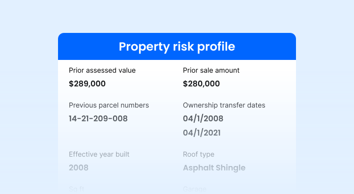
Real estate property characteristics can also be used to build comprehensive property risk profiles that cover a property’s age, construction materials, and features like a pool or fireplace. Those profiles reduce time spent on manual research and limit the need for in-person property inspections.
DepreciMax, a property analysis platform built for short-term rental investors, uses property characteristics about land value as part of the structured data foundation behind its bonus depreciation model. That gives users a fast, affordable way to understand a property’s risk, opportunity, and financial profile before making an offer.
To learn more about how DepreciMax uses property characteristics, check out their full success story!
Telecom
Before installing cell towers, fiber, cable, or other infrastructure, telecoms can map terrain, parcel boundaries, and existing structures using property characteristics. That data helps telecoms:
- Plan network expansion
- Optimize installation locations
- Reduce the risk of property damage
Zoning and parcel boundary data can also support right-of-way negotiations. When telecoms understand where parcel boundaries exist and what those parcels are zoned for, less manual research is required when applying for permits.
Utility
Like telecoms, utility companies can better plan infrastructure when their decision-making relies on accurate property characteristics, such as parcel data and land use. Property characteristics also help utility companies estimate service costs with data like:
- Building square footage
- Year built
- Unit count
- Water service type
- Sewer type
- Heat fuel type
- Air conditioner system
To improve marketing and maintenance planning, utility companies can analyze property characteristics regarding age, size, systems, and features across a service area. That way, you can tailor marketing campaigns to communities that are more likely to need upgrades, repairs, or new services.
Government
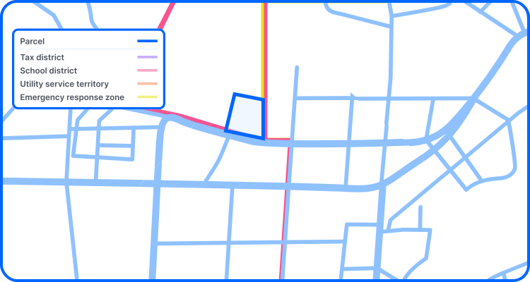
Accurate parcel boundary data is especially important to government agencies that determine whether a property falls within a specific jurisdiction, whether that’s a school district, tax district, utility service territory, or an emergency response zone. When that data is inaccurate, noncompliance can follow.
Other common use cases for government agencies include:
- Tax commissions or administrative offices visualizing and synchronizing tax records with parcel boundary data
- Planning and zoning departments using land attributes to review development proposals and enforce zoning regulations
- Geographic information systems (GIS) teams building databases that include property characteristics to improve analysis of zoning, utilities, and other infrastructure
Where property characteristics data comes from
Businesses across industries rely on property characteristics derived from:
- Property value assessments: Assessors’ estimates of property value that typically include structural attributes (e.g., square footage and the number of bedrooms in a home) and financial attributes (e.g., the income the property can generate and past sales)
- Tax records: Documentation of a property’s tax rate, billed amount, tax year, etc.
- Parcel records: Private and public records collected by county recorders and cadastral survey programs that identify a parcel's boundaries, acreage, and other parcel-specific data
- GIS databases: Geographic information systems used to capture, visualize, and analyze spatial data—like latitude and longitude coordinates, FIPS Codes, census blocks, and census tracts
- Aerial imagery: Visual data used to identify structures, exterior features, etc.
- Public records: Deeds, mortgages, permits, and public records related to property ownership and changes
Because characteristics of property data come from different sources, they’re most useful to businesses across industries when they’re standardized and aggregated.
For example, let’s say an insurer is assessing the risk of two properties. Based only on structural attributes from a property value assessment, the properties receive identical risk scores. But when the insurer also evaluates property characteristics from a GIS database, it’s clear that one property is near a floodplain, while the other is located at a higher elevation.
Without property characteristics from both data sources, the insurer could build risk models that treat two very different properties as though they were the same.
Real estate companies and proptechs also benefit from property characteristics from multiple sources. Data from tax and public records helps them establish:
- Who owns a property
- What it’s worth
- What it can be used for
Similarly, telecom and utility companies better understand where a property is, what exists there, and how a property is serviced when they rely on property characteristics from both parcel records and value assessments.
Businesses in any of these industries could aggregate data from these sources themselves, but that means standardizing property characteristics across different formats, linking them to the correct properties, and maintaining updates from sources that operate on different schedules.
Smarty’s US Parcel Boundary Data and US Property Data help businesses avoid that manual, time-consuming work by providing access to enterprise-ready datasets of standardized property characteristics.
Here’s how standardized characteristics of property and parcel data work to create better business outcomes.
Why standardized property characteristics data matters
US Property Data starts with an input address.
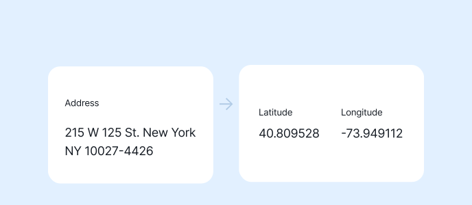
After verifying that address, US Property Data finds the latitude and longitude coordinates of the parcel associated with it. Using that information, US Property Data identifies the address’s SmartyKey, a persistent unique identifier (PUID), to connect up to 350 property characteristics to the address.
For example, US Property Data shows that the property at 215 W 125th St, New York, NY 10027-4426 sits at an elevation of 26 feet, has 142,625 square feet of office space, and has a total market value of $43,905,000. Check out the rest of the attributes US Property Data returns for that address here!
Those property characteristics can include 60+ location attributes, 150+ building attributes, and 130+ financial data points. (For a full description of each available data point, check out our complete attribute list!)
US Property Data makes it easy to link property characteristics to addresses, helping businesses improve risk assessments, property profiles, infrastructure planning, and marketing campaigns. Plus, those workflows become even stronger when businesses pair US Property Data with US Parcel Boundary Data.
US Parcel Boundary Data provides businesses with parcel boundaries and data for any county nationwide, eliminating the need to stitch together thousands of county sources. US Parcel Boundary Data is a dataset delivered in the format that best suits your workflow, whether that’s:
- Parquet
- CSVWKT
- GeoJSON
- GeoPackage
- Shapefile
Like US Property Data, US Parcel Boundary Data is equipped with SmartyKey, so businesses can easily link parcels to addresses. That way, businesses can access hundreds of property characteristics with a single API call or a file download, all while avoiding time-consuming data aggregation and maintenance.
Conclusion
Property characteristics provide businesses across industries with the property, parcel, land, and building attributes they need to assess risk, analyze properties, inform decision-making, and market effectively.
From structural and physical attributes to ownership and parcel data, property characteristics serve as foundational points of location intelligence for insurers, real estate businesses, proptechs, telecoms, and utility companies.
If you’re looking for nationwide property characteristics from a single provider, check out Smarty’s US Parcel Boundary Data and US Property Data. Start a 42-day free trial to give US Property Data a test drive, or download a free sample list of 19,000+ addresses to see what US Parcel Boundary Data has to offer.
Still have questions? Talk with a living, breathing address expert.
Frequently asked questions
Property characteristics are the property, parcel, land, and building attributes that distinguish one property from another, including information about structures on the property, the property itself, and the parcel or land the property encompasses.
Building attributes describe the structures on a property, from construction and roof type to square footage and year built.
Examples of property characteristics include:
- Structural: Structure square footage, year built, and construction type
- Physical: Elevation, acreage, and lot square footage
- Location: Latitude, longitude, and address
- Legal: Legal description, zoning, and parcel number formatting
- Assessment: Assessed value, total market value, and tax billed amount
- Ownership: Owner’s full name, ownership type, and ownership transfer date
- Utilities: Sewer, water service, and heat fuel type
- Parcel: Parcel acreage, ID, and address
Property attributes are a type of property characteristic that describes the property itself (e.g., loan amount, sale price, address, elevation). Property characteristics include property attributes as well as attributes of a building, land, and parcel.
Property characteristics come from a variety of sources, including county assessors, parcel records, tax records, GIS databases, aerial imagery, and public records.
Each industry has different use cases for standardized property characteristics:
- Insurance, real estate, and proptech companies: Evaluate property risk and build property profiles
- Telecoms and government agencies: Make informed decisions about infrastructure planning, tax records, development proposals, or jurisdiction assignments
- Utility companies: Predict when properties are due for repairs and tailor marketing campaigns towards those properties
Access nationwide or countywide property characteristics data through Smarty’s US Property Data, which includes 350+ property characteristics and building attributes, and US Parcel Boundary Data, which provides standardized parcel boundaries and 110+ parcel attributes.
Was this helpful?