
Using geospatial data for telecommunications and network optimization


What is geospatial data, and why does it matter for telecom?
Geospatial data for telecommunications connects your network, customers, and infrastructure to real-world locations. It includes addresses, geographic coordinates, coverage boundaries, fiber routes, cell towers, and property data (and more!), giving you a clear picture of where service is available, where demand exists, and where coverage gaps remain.
As a telecom provider, ZIP Codes and broad coverage estimates are not enough. You need address-level location intelligence to identify serviceable locations, prioritize network expansion, and maximize the impact of infrastructure investments.
With accurate geospatial data, you can validate customer locations, improve serviceability checks, model coverage, and support field operations. It also gives you a stronger foundation for network planning, operations, and customer experience.
Building that foundation of geospatial data for telecommunications typically requires a combination of GIS, geocoding, address verification, and property intelligence. Together, these tools provide the accuracy and context you need to plan, build, and optimize your network.
Explore the solutions below to see how geospatial data can support your operations.
Table of contents
- Why telecom network optimization requires geospatial data
- Why telecom network planning depends on geospatial intelligence
- Using geocoding to map telecom networks
- Why address verification matters for geospatial analysis
- Combining address verification with geocoding
- How address verification + geocoding improve telecom workflows
- Using property data to prioritize network expansion
- The importance of geospatial data intelligence in telecom
- Conclusion: Powerful planning through geospatial integration
Why telecom network optimization requires geospatial data
Telecom networks are built around physical locations. Every serviceable address, coverage area, fiber route, cell tower, and network asset has a geographic component that affects how you plan, operate, and expand your network.
To make informed decisions, you need a clear view of where customers are located, where service is available, and where growth opportunities exist. Geospatial data for telecommunications provides that context, helping you analyze coverage, validate serviceability, improve planning decisions, and meet regulatory reporting requirements.
Without accurate location intelligence, it becomes much harder to assess network performance, identify underserved areas, and prioritize investments. The result is slower decision-making, less efficient planning, and a greater risk of directing resources to the wrong places.
The role of location intelligence in network growth
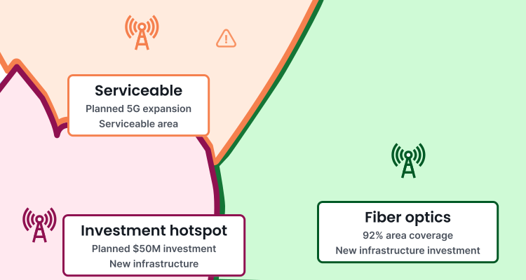
The role of location intelligence in network growth is to help you identify where expansion opportunities exist and where investments will have the greatest impact. By using geospatial data for telecommunications, you can make more informed decisions about where to extend service, prioritize projects, and allocate resources.
Accurate location data also supports broadband funding and regulatory initiatives. As the FCC continues to improve broadband maps with more detailed service availability data, you need to use reliable information beyond the FCC to validate coverage, support reporting requirements, and identify areas that may qualify for funding.
With a clearer understanding of your service footprint and market opportunities, you can target fiber, wireless, and last-mile investments more strategically while reducing planning risk.
Why telecom network planning depends on geospatial intelligence
Telecom network planning depends on geospatial intelligence because network coverage is fundamentally a location-based challenge. To make informed expansion and investment decisions, you need to understand not just where service is offered, but which specific locations can actually be served. Geospatial intelligence gives you the location-level visibility needed to accurately assess coverage, identify gaps, and prioritize network investments.
Understanding network coverage
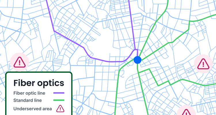
Understanding network coverage requires more than knowing whether a census block and tract, ZIP Code, or region is served. You need to know which locations can actually receive reliable broadband internet connections.
That level of detail is increasingly important because broadband funding opportunities are tied to location-level service availability. The Broadband, Equity, Access, and Deployment (BEAD) program, which includes $42.45 billion, is tied to broadband infrastructure and prioritizes unserved and underserved broadband-serviceable locations. For providers pursuing expansion, accurately identifying and documenting those locations can help support funding eligibility and strengthen investment decisions.
Address-level location intelligence gives you a more accurate view of coverage, helping you uncover gaps that may be hidden within otherwise served areas. With that insight, you can identify expansion opportunities, avoid unnecessary overbuilding, and direct infrastructure investments where they will have the greatest impact.
Preventing overlap and inefficiency
Geospatial data for telecommunications helps you combine location-level market demand, existing assets, serviceability, terrain, rights-of-way, telecom network infrastructure, and competitor coverage into one planning view. That makes it easier to see where infrastructure is truly needed, where expansion would overlap with existing coverage, and where investment can close the most meaningful gaps.
Geospatial data helps you make more strategic infrastructure planning and investment decisions. When you can visualize underserved areas on a map, it’s easier to prioritize eligible or high-demand locations and design buildouts that reduce wasted spend.
Using geocoding to map telecom networks
Accurate telecom network planning depends on being able to place customer locations, service areas, and telecom network infrastructure precisely on a map. Geocoding makes that possible.
There are two ways you can use geocoding: standard geocoding and reverse geocoding. Both help connect location intelligence to real-world places, but they work in opposite directions.
Geocoding is the process of converting an address or location description into its corresponding geographic coordinates (latitude and longitude). As a telecom provider, that means you can accurately map customer addresses, service locations, cell towers, network assets, and potential broadband infrastructure projects.
However, not all geocoding solutions deliver the same level of accuracy. Some place an address along a street segment or at the center of a ZIP Code, while others can identify the actual rooftop or structure. For network planning, serviceability analysis, and broadband expansion, rooftop geocoding gives you a more precise view of where customers and infrastructure are located, helping you make more confident planning and investment decisions.
Reverse geocoding works in the opposite direction. Instead of starting with an address, reverse geocoding takes geographic coordinates and returns the closest known address or a list of plausible nearby addresses. This can help telecom teams connect network infrastructure, field data, mobile signals, installation records, or service requests back to real-world locations.
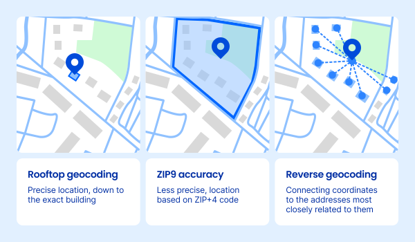
Geocoding can happen one address at a time, but many providers use API to batch-process large address lists and integrate location intelligence across multiple systems and workflows.
Together, geospatial data for telecommunications, like geocoding and reverse geocoding, give you a more flexible way to use location data across your workflows, with significant benefits.
Benefits of geocoded network data
You have a lot to gain by relying on accurate geocoded network data, such as the ability to:
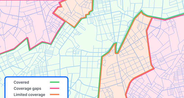
- Visualize towers, cables, and coverage zones
- Identify real-world coverage gaps
- Evaluating service at the building level
- Compare network coverage against actual customer demand
- Prioritize expansion into the underserved or high-growth areas
- Reduce overlap, overbuilding, and inefficiencies in infrastructure spend
- Improve serviceability checks before customers sign up or are offered location-based deals
- Route technicians more efficiently for installs, maintenance, and repairs, especially for rural areas where a building may be on the corner of a multi-acre lot or an apartment in densely populated areas
- Connect outage reports to specific locations, assets, or service areas
- Support permitting, right-of-way planning, and field ops
- Strengthen broadband funding, reporting, and compliance workflows
- Analyze competitor coverage and market expansion opportunities
Accurate geocoded network data helps telecom providers visualize real-time problems. With location intelligence at the address or building level, teams and field operations are given a clearer view of where infrastructure exists, where it’s needed, and where investment will have the greatest impact.
Integrating geocoding into telecom GIS data
For geocoded network data to be useful, it needs to fit into the systems you already use to plan, monitor, and optimize your networks.
When address-level coordinates are integrated into a geographic information system, your telecommunications company can layer customer locations, service areas, network assets, outage reports, permitting zones, and expansion opportunities into a single operational view. That makes geospatial data for telecommunications easier to use across all workflows.
A reliable geospatial database and mapping tool helps turn those coordinates into actionable decisions. Instead of treating customer records, network assets, and service eligibility as separate datasets, telecom providers can connect them by location, and that location (if using Smarty) can be linked to a persistent, unique identifier that tracks all historical address data tied to that location.
This makes it easier to evaluate coverage, prevent infrastructure overlap, identify underserved areas, and prioritize buildouts based on real-world demand.
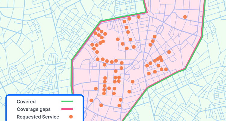
Smarty’s geocoding APIs can support that workflow by converting addresses into precise latitude and longitude coordinates for use in GIS platforms, network-planning tools, serviceability systems, and internal dashboards. With accurate geocoding built into the data pipeline, telecom providers can move from static address lists to location-aware decision-making across the entire network lifecycle.
Why address verification matters for geospatial analysis
Another tool used in geospatial data for telecommunications is address verification. Address verification confirms whether an address is real, valid, standardized, and deliverable using authoritative data sources, such as USPS data. Geospatial analysis is only as reliable as the location data behind it, so if you’re mapping inaccurate, incomplete, duplicated, or nonstandard addresses, the resulting coverage models may show the wrong service areas, miss real demand, or create false confidence around where the network can actually reach.
Verified addresses create a stronger foundation for network planning and optimization. Before an address can be geocoded, mapped, analyzed for serviceability, or compared with existing infrastructure, it must represent a real location.
Address verification helps clean and standardize that data so that coverage models reflect actual homes, businesses, apartments, and service locations rather than messy database entries or even synthetic or fraudulent addresses. That improves the accuracy of gap analysis, expansion planning, technician dispatch, direct mail campaigns, and serviceability checks.
Reliable coverage models start with reliable address data. By verifying and standardizing addresses, you can improve geocoding coordinates, strengthen serviceability analysis, and make more informed infrastructure planning and investment decisions. With Smarty's US Address Verification, you get clean address data and metadata insights that support telecom planning.
Metadata insights for telecom planning
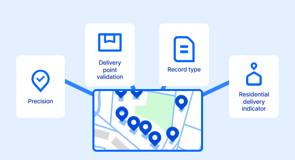
Although Smarty’s address verification tools can return up to 55 points of metadata for every address, we’ve pulled out the few that we believe will have the biggest impact on optimizing your business:
Delivery Point Validation (DPV): Confirms real, deliverable addresses
Precision: Shows level of precision achieved, such as rooftop-, ZIP-, or street-level.
Record type: Helps identify the type of address record, which may matter when distinguishing street addresses from PO Boxes, rural routes, or CMRAs that could affect serviceability.
Residential Delivery Indicator (RDI): Differentiates residential vs. commercial demand
Urbanization: Particularly useful for Puerto Rican addresses, where urbanization can be necessary for accurate address identification and service planning.
ZIP+4 segmentation: Provides granular geographic grouping for more precise mapping
Smarty address verification
Smarty metadata features
Combining address verification with geocoding
When we combine the powers of address verification and metadata with rooftop-accurate geocodes, the results speak for themselves. Address verification helps confirm that the location is real, standardized, and usable. Geocoding helps place that verified location on a map with the precision required for planning, routing, serviceability, and coverage analysis.
This combination is especially valuable because network decisions depend on both clean records and accurate coordinates. A misspelled, incomplete, or duplicated address, or even one that’s missing secondary information, can create problems across multiple channels. But when that same address is verified, standardized, enriched with metadata, and converted into a precise latitude/longitude coordinate, it becomes much more useful.
The real benefit is consistency.
You have address and location data spread across CRMs, GIS platforms, serviceability tools, billing systems, network-planning software, and field operations platforms. If each system stores or interprets the same location differently, you can end up with conflicting views of customer demand, coverage, eligibility, and infrastructure needs.
Combining address verification with geocoding creates a cleaner location-data foundation that can move more reliably across those systems. Sales teams can check whether a location is serviceable. Network teams can see where demand overlaps with existing infrastructure. Field teams can route technicians to the right place. Compliance teams can support broadband funding, reporting, and documentation with more confidence. And executives can make expansion decisions using standardized, mapped, and location-tied data.
In other words, address verification answers the question, “Is this a real, usable location?” Geocoding answers the question, “Where is it?” Together, they help you make better decisions about where to serve, build, optimize, and invest next.
How address verification + geocoding improve telecom workflows
Together, they create cleaner datasets, stronger maps, and more accurate network decisions.
| Workflow area | Address verification adds | Geocoding adds | Telecom impact |
|---|---|---|---|
| Data quality | Validates and standardizes addresses | Turns verified locations into coordinates | Creates consistent records across systems |
| Coverage analysis | Removes bad or incomplete location data | Maps service locations precisely | Improves visibility into real coverage gaps |
| Serviceability checks | Confirms real, deliverable addresses | Places each address in its exact geographic context | Supports more accurate availability decisions |
| Network planning | Cleans customer and infrastructure records | Enables spatial analysis of demand and assets | Helps reduce overlap and optimize buildouts |
| Field operations | Improves address accuracy for dispatch | Supports routing and map-based workflows | Boosts technician efficiency and reduces missed visits |
Best together: Verified addresses + precise coordinates = better telecom mapping, planning, and optimization.
Using property data to prioritize network expansion
Address verification and geocoding show where a location is. Property data helps explain what that location represents.
Context matters. A single-family home, apartment building, commercial property, rural parcel, or mixed-use development may each represent a different level of demand, cost, and service complexity. For example, serving a multi-dwelling unit may require a very different deployment strategy and investment than serving a single-family residence.
That level of planning matters because broadband infrastructure investment is massive. USTelecom estimates that broadband providers invested $89.6 billion in U.S. communications infrastructure in 2024, meaning even small improvements in buildout targeting, serviceability accuracy, and network planning can have a meaningful impact.
For example, multi-unit buildings may offer concentrated customer potential, commercial zones may signal higher-capacity service needs, and rural parcels may require more careful routing and installation planning. When paired with verified addresses and precise geocodes, property data helps telecom providers identify high-demand areas, reduce wasted spend, and prioritize buildouts with stronger business potential.
Smarty’s US Property Data can add this context directly to telecom planning workflows, turning basic address records into richer location intelligence for expansion, sales, serviceability, and field operations.
The importance of geospatial data intelligence in telecom
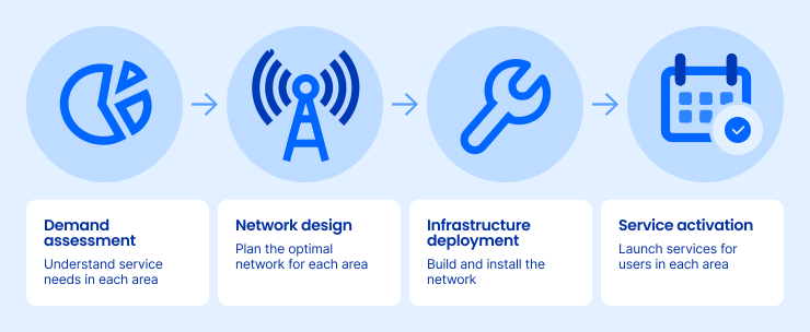
If you’re a telecommunications company, you need accurate location data across nearly every workflow—not only to streamline operations, but also to guide long-term infrastructure investments. With the industry expected to invest $130B-$150B over the next 5-7 years, address-level geospatial intelligence helps you identify where fiber expansion, wireless densification, and new network investments will have the greatest impact and return.
Geospatial data for telecommunications helps connect those workflows around a shared understanding of place. Instead of treating customer records, network assets, property details, and service areas as separate datasets, you can connect them using verified addresses, precise coordinates, and property context, all under one SmartyKey®.
That gives you a unified view of customers, assets, coverage, and growth opportunities across your network.
Smarty's APIs help you bring address verification, geocoding, reverse geocoding, and property data into your existing systems, putting location intelligence directly into the workflows where your teams are already making planning, serviceability, and investment decisions.
Conclusion: Powerful planning through geospatial integration
Telecom network optimization depends on accurate, connected geospatial data.
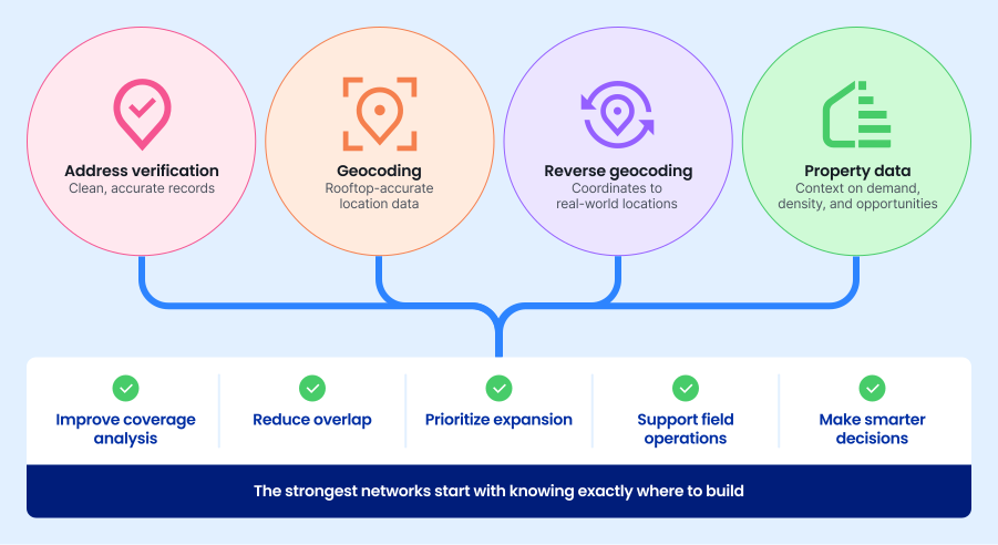
Verified addresses give you cleaner records. Rooftop-accurate geocodes place those records precisely on the map. Reverse geocoding connects coordinates back to real-world locations. Property data gives you context about demand, density, and service opportunities.
Together, geospatial data for telecommunications helps you improve coverage analysis, reduce overlap, prioritize expansion, support field operations, and make smarter decisions about telecom network infrastructure.
Smarty offers address verification, geocoding, reverse geocoding, and property data APIs that help you build a stronger location-data foundation for planning, mapping, serviceability, and long-term network optimization.
The strongest networks start with knowing exactly where to build. When you trust the location, you can trust the plan.
Was this helpful?