Geocoding software for telecommunications
Geocoding software for telecommunications is your secret weapon for smarter, faster, and more accurate network decisions. It takes a physical address and converts it into hyper-accurate geographic coordinates (a.k.a. latitude and longitude) so you can get precise location mapping, spatial analysis, expansion planning, service eligibility, discount qualifications, and customer experience improvements—all from one powerful tool.
If you're in telecom, you know how fast things move. Geocoding software helps telecom companies stay on track—and ahead. With FCC regulations tightening and new funding programs requiring rooftop-level accuracy, relying on ZIP Code or ZIP+9-level geocoding just won't cut it. You need exact coordinates, rooftop geocodes, and precise address components to make informed decisions and stay ahead of the curve. That's where advanced telecommunications data solutions come into play.
If you're still clinging to that outdated ZIP-level geocoding software... It's time to get on the rooftop geocoding train. Choo choo! 🚂 Smarty's geocoding software for telecommunications is built for where you're headed, not where you've been.
You can try our telecom data products and geospatial solutions for FREE—or keep scrolling to see how our address validation and telecom-specific data tools can help you unlock millions of addresses, optimize your telecommunication database, and supercharge your revenue.
Now, here are the stops this train (of thought) will be making:
- Importance of geocoding in telecommunications
- How geocoding works
- Benefits of geocoding software
- Impact on operational efficiency
- Future trends in geocoding and telecommunications
Importance of geocoding in telecommunications
In telecommunications, location accuracy isn't just nice to have; it's vital to your success. That's why you need best-in-class geocoding software as the backbone of your strategy, especially as you expand fiber or fixed wireless access (FWA) networks. Rooftop geocoding gives you the precision to effectively plan your network and improve your asset management by:
- Pinpointing underserved areas with high growth potential
- Predict demand based on actual population distribution
- Simulate signal propagation based on actual topography
- Evaluate terrain or foliage obstructions using elevation models
- And ensure customers aren't blocked by hills or trees that aren't evident for a parcel-level map.
- Optimizing tower placement and infrastructure deployment
- Delivering services to the right building, not just the nearest address or parcel centroid
How rooftop geocoding software helps in network planning and asset management

If you're planning fiber expansion, mapping service areas, or managing network assets, rooftop geocoding is your secret weapon.
Unlike interpolated or parcel-based coordinates, rooftop geocoding ties each address to its true physical location. It often uses high-resolution imagery, building footprints, and authoritative datasets to give precise latitude and longitude coordinates for each structure—or even each unit—on a property.
Compare that to parcel centroid data, which drops a single point in the middle of a huge apartment complex or business park. That's like throwing a dart at a map and calling it good.
Say you're looking at a single dot on a parcel and assume it's one building, when in reality it's a 5-building, 300-unit residential complex. That single oversight can throw off your entire network planning and serviceability model.
Without that precision, you might approve a tower location assuming it'll serve 80 households, only to discover after installation that 30 of those rooftops are behind a ridge. Yikes.
With enriched, accurate, and exact address and location intelligence, including rooftop coordinates, you can prioritize rollouts based on real-world spatial distribution instead of ZIP Codes. This helps avoid wasted resources, missed connections, and frustrated customers.
You'll also make smarter asset management decisions. By linking rooftop-level geocodes to existing infrastructure like splice points, fiber routes, or towers, you can proactively maintain, repair, and upgrade your network, without sending crews on wild goose chases.
It gets even better when rooftop geocoding is paired with robust address validation. After all, pinpoint precision only works if the original address is accurate. Validated addresses ensure you're mapping the right structure at the right location.
Rooftop geocodes enable micro-targeted infrastructure planning. Instead of relying on approximations, you're working with the actual location of the serviceable structure. This reduces planning errors, fieldwork surprises, and costly rework.
Optimizing service delivery
Service delivery in telecom means getting customers connected with precision, speed, and scalability. Whether it's an install, a repair, an upgrade, or an outage response, you've got one mission: get the right person to the right place with the right info and gear the first time.
That's where geocoded telecommunications data solutions turn raw addresses into actionable location intelligence so you can:
- Deliver services to the correct door—You need rooftop-accurate geocodes built to recognize that apartment and unit numbers are the datapoints that should be fueling your mapping services. Without it, your technicians will be delayed finding the correct unit, fail to install due to gate codes or access issues, or reschedule visits, costing your organization in truck roll time and money.
- Preverify serviceability before truck rolls—An address should be verified before the trucks roll out! Geocoding software allows telecom operators to check that an address is in a current service area, is capable of supporting the requested speed, and is near available infrastructure (fiber, coax, wireless LOS, etc.).
- Manage multi-unit and complex property types—Untangle the mess of multi-dwelling units (MDUs), commercial campuses, and mixed-use buildings. A robust telecommunications database can distinguish between a home office, small business, residential tenant, and more, giving them the right bandwidth needs, service plans, and support tiers to support customers adequately.
- Track and audit every step—When every address and asset in your network can be tied to a persistent geocode (like a SmartyKey®), you up your tracking and auditing game. Field service reports, historical service issues, and upgrades and expansions can be linked to exact geocoordinates with complete data continuity. Imagine having powerful address geocoding software that transforms your regulatory reporting from a challenging task to a strategic advantage. Rooftop geocoding emerges as a critical tool, providing precise point address geocoding that delivers accurate latitude and longitude coordinates, automated data verification, and real-time location intelligence. Advanced geocoding technologies have demonstrated the ability to reduce reporting errors by up to 92%, giving you an edge in maintaining compliance.
Check out how Deduce Technologies used Smarty's address autocomplete and geocoding APIs to improve last-mile delivery for telecom and logistics clients.
Because when the address is right, everything else just works better.
How geocoding works

As we've mentioned a few times now, address geocoding is converting a physical address into geolocation coordinates to locate an address globally. These coordinates help businesses, including ISPs and fiber network providers, pinpoint the exact location of homes and businesses.
Every address has geographic coordinates (latitude and longitude), but not all address geocoding software is created equal. Different levels of address geocoding offer varying degrees of accuracy, and if you're relying on anything less than rooftop-level address geocoding, you may be working with inaccurate data that leads to costly mistakes.
Here's a breakdown of different types of geocoding software for telecommunications:
- ZIP-level geocoding: This uses a postal code to approximate a location, often covering multiple buildings or even entire neighborhoods. It's good for high-level analysis but doesn't give the precision needed for service qualification.
- ZIP+4 and ZIP+9 geocoding: This is more precise than basic ZIP-level geocoding but still doesn't pinpoint a specific address. It's useful for some purposes but not for exact service deployment.
- Rooftop geocoding: Point address geocoding provides exact latitude and longitude coordinates for a specific address, ensuring precise service qualification and installation. If you want to convert a ZIP Code to latitude and longitude with high accuracy, rooftop geocoding is your best bet.
- Smarty's rooftop-accurate geocoding: In addition to the point address geocoding, Smarty's geocoding is bolstered by address validation, meaning our match rates are more accurate, and fewer false positives are being pushed through to your database.
Want to see rooftop geocoding in action? Smarty's address geocoding API is free to try, and places a pin directly on the center of the rooftop to which each address is linked.
97% of our address geocodes are rooftop- or parcel-accurate, and unlike some providers we know, we'll tell you when we can't provide that level of accuracy so you can strategize your next steps.
Plus, using rooftop geocoding gives you access to SmartyKey®, our persistent, unique identifier, which understands the history of any associated alias locations. You'll also have access to 55 points of metadata (including RDI!) and 210 M+ addresses (USPS and non-postal database) at speeds 10,000 times faster than the other guys.
Let's explore why rooftop geocoding is a big deal for your network planning and service qualification needs.
Understanding geospatial data
Say it with us this time: Geocoding turns an address into latitude and longitude coordinates, enabling it to be placed precisely on a digital map. 🎯
But not all geocodes are created equal.
Some tools give you a parcel centroid, which just drops a pin in the center of a property. That's fine if you're mapping wide zones or rural farmland. But in the world of telecommunications data and network rollouts, "close enough" isn't good enough.
To deliver accurate service, you need point address geocoding that takes you to the actual rooftop—the true physical location of the structure, not just a general estimate.
Advanced geocoding software for telecommunications goes even further. It can distinguish between individual units, recognize critical address components (like building numbers, floor levels, and suite identifiers), and validate that those addresses are real and ready for service. This is where rooftop-level data becomes your secret weapon for smarter spatial analysis, optimized coverage planning, and fewer missed connections.
Address matching techniques

Effective geocoding begins with proper address validation and parsing. Without clean, standardized input, you risk false positives (addresses that are changed in order to obtain a match when it's actually just bogus) that can reroute crews miles away from the correct location.
Smarty will never change an address to obtain a match without telling you we did so and what was changed. We flag when address components change during validation, so nothing gets silently swapped behind the scenes. We don't like it when our competitors try to pad their numbers with false positives, because we know that you rely on that address data for scaling and growing your network.
Integrating with GIS systems
Geocoding really shines when it's integrated into a Geographic Information System (GIS). With the right tools, you can visualize everything from signal coverage gaps and service availability zones to network asset locations and customer clusters, turning static spreadsheets into dynamic smart maps.
Benefits of geocoding software
Basically, the benefits of geocoding software for telecom break down into these categories:
- Precision: With rooftop-level address geocoding, you get the exact latitude and longitude to address conversion for each property. This ensures that you can accurately identify serviceable locations. Address point geocoding can be especially helpful when differentiating between units in a multi-family property.
Service qualification: It allows you to verify whether a specific property is eligible for service, reducing the risk of mistakes and improving customer satisfaction.
With pinpoint address geocoding, you can confidently determine whether an address is truly serviceable. Instead of relying on a ZIP Code to latitude-longitude data, which can cover an entire neighborhood and lead to inaccurate service availability, you need a more precise solution.
By using rooftop geocoding, you can convert a ZIP Code to latitude and longitude and pinpoint exactly which buildings qualify for service, reducing wasted resources and frustrated customers.
In fact, the FCC has found that inaccurate broadband mapping has cost telecom companies millions in wasted infrastructure investments. With precise address geocoding software, you can avoid these costly mistakes and ensure every installation is backed by reliable data.
- Cost savings: Using address point geocoding reduces truck rolls and installation errors, leading to significant savings in time, labor, and operational costs.
The result? No more delays, misrouted technicians, or costly inefficiencies. In fact, businesses that implement precise geospatial data can reduce operational costs by up to 10-15%.
Also, considering that inefficient routing costs businesses $87 billion annually, switching to rooftop geocoding is a financial necessity. - Integration: This data integrates seamlessly with CRM, OSS, and BSS systems, streamlining your operations and making them more efficient.
Also, with point address geocoding, technicians are now empowered with precise, rooftop-level geocoded addresses, allowing them to reach the site faster and start working immediately, without arriving frustrated (or meeting an already frustrated customer).
Rooftop geocoding takes precision to the next level by pinpointing the exact service address location, down to the specific spot on a building's roof where work needs to be performed. This isn't just guesswork—address geocoding software leverages high-resolution satellite imagery and advanced mapping algorithms to provide accurate coordinates within a few feet.
Routing software seamlessly integrates these precise coordinates, optimizing routes based on real-time traffic conditions, technician proximity, and exact latitude and longitude to ZIP Code conversion. This transforms what was once a hit-or-miss approach into a streamlined, data-driven service deployment strategy.
With geocode ZIP Code data enhanced by rooftop-accurate precision, you can stop wasting time and money on inefficient installations and integrations.
The accuracy of your address geocoding data can either make or break your network planning, service qualification, and customer satisfaction. While using ZIP Code to lat long data might seem like an easy shortcut, it falls short regarding precision.
Rooftop-level address geocoding, on the other hand, provides exact coordinates for a specific property, ensuring that your service deployments are accurate, efficient, and error-free.
Impact on operational efficiency
Cost reduction strategies
Fiber telecom and ISP companies that use ZIP-9 address geocoding unknowingly make costly mistakes. These are the main revenue eaters:
- Higher truck roll costs: Truck rolls cost significant amounts of money as is. If you use “ZIP Code to lat long” geocoding practices when you send out your technicians, they aren't even sure if they're headed to the right building, let alone the unit.
Your organization is paying for these trips in gas, time spent by the tech, time between the tech and administrative staff trying to figure out the right location, wear and tear on the vehicle, and customer dissatisfaction. If your tech is lost because your address geocoding isn't precise enough, money and productivity are down the drain.
Did we mention the opportunity cost you're missing out on by not being able to help with the next installation in line? Yeah. That too. - Overlapping coverage areas: Competing networks may operate within the same ZIP Codes, creating a scenario where it's difficult to pinpoint which areas are truly exclusive to your network. ZIP-9 geocodes don't provide a pinpointed enough view of your market, making it more challenging to identify the exact location of potential customers as you sift through some guesswork in a highly competitive area.
- Inefficient service qualifications: When you don't know where a customer is located (residential or business), it's harder to qualify them for services or plan your network expansions effectively.
It's also tough for your mapping software to work with geocodes that aren't rooftop-accurate, especially in rural locations where the structure may be built on a corner of the property, or in urban areas where address geocodes are VERY close together.
- Wasted marketing dollars: If your address data is inaccurate, your marketing efforts will miss the mark. You might be sending promotional materials or service offers to people who don't actually live in the right area and may not qualify, especially given fiber installation limitations.
- Angry customers: We touched on this above, but consider the damage a poor experience with your company can do to your reputation. If you bait-and-switch potential clients before your area expansion is ready, they'll likely be sour from that first encounter and won't want your service even when they finally DO qualify. They might also spread the word about their bad experience with your organization to their neighbors, costing you potential future business.
- Wasted development dollars: Address geocoding reduces unnecessary excavation and minimizes wasted survey resources. Underground fiber deployment costs range from less than $5 to $50 per foot, with typical costs between $10 and $27 per foot, and aerial deployment costs range from $3 to $30 per foot, typically between $5 and $14 per foot, so optimizing routes can result in solid cost savings.
Reduce unnecessary excavation, minimize wasted survey resources, and prioritize neighborhoods with the highest potential customer concentration with rooftop-accurate geocodes. This technology allows your field technicians to navigate more efficiently, cutting down on time-consuming manual site surveys and reducing even more expensive truck rolls.
So yeah, accuracy is essential. You want to be sure that your service reaches the right person at the right address every stinkin' time.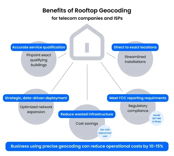
By investing in high-quality rooftop geocoding, you're not just saving money—you're transforming how you approach network expansion, making your operations more precise, efficient, and cost-effective.
The result is a leaner, smarter approach to building out your telecommunications infrastructure that can save your company significant time and resources. From your perfectly geocoded rooftop, you can bask in the boost to your bottom line.
Increasing network safety
Knowing exactly where your infrastructure is, down to the meter, means safer, faster, and more efficient operations. With geocoded telecommunications asset data, your teams can respond immediately to storm damage, fiber cuts, downed lines, or service disruptions with greater precision.
By connecting every pole, splice point, cabinet, and drop to a persistent, rooftop-level geocode, you minimize confusion in the field and maximize uptime. Geocoding isn’t just good practice—it's often required. It helps meet regulatory compliance and service documentation standards for reporting and audits.
When your mapping software is powered by Smarty's accurate address validation and point address geocoding, your service crews won't just try to find the issue—they'll go straight to it the first time.
Supporting sustainable development
Sustainable development doesn't just happen; it's built on accurate data, and better data starts with better geocoding.
Green initiatives like smart city planning, clean energy routing, and optimized infrastructure placement rely on highly accurate location data. A parcel centroid just won't cut it when you're routing underground conduits or placing solar arrays.
Rooftop-accurate coordinates support:
- Smarter fiber and fixed wireless rollouts that reduce overbuild and waste
- Energy-efficient network design
- Streamlined permitting and land use decisions
- Coordinated upgrades aligned with local environmental policies
Hyper-specific telecommunications data solutions ensure the right upgrades happen in the right places, at the right time, so your network grows clean, lean, and future-ready.
Future trends in geocoding and telecommunications
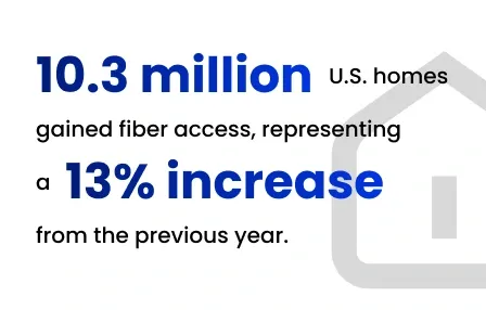
As an Internet Service Provider (ISP), you're navigating one of the most dynamic landscapes in telecommunications. With 43% of U.S. households now connected to fiber-optic networks and the global market projected to reach $9.4 billion by 2028, your opportunity for strategic network expansion has never been more critical.
In 2024, you've witnessed a remarkable milestone: 10.3 million U.S. homes gained fiber access, representing a 13% increase from the previous year. But you know better than anyone that expansion isn't just about numbers.
Your ability to leverage address geospatial technologies can make the difference between efficient deployment and costly miscalculations. It's about precision.
Using advances in geospatial technology to fill evolving telecom industry needs
Consider how point address geocoding transforms your network planning strategy. When you're converting ZIP Codes to latitude and longitude, you're doing more than plotting points on a map. You're creating a strategic blueprint for telecommunications network expansion. Your address geocoding software becomes a powerful tool that enables you to:
- Identify exact service locations with unprecedented accuracy
- Minimize infrastructure investment waste
- Accelerate network rollout times
- Optimize resource allocation across potential service areas
The most advanced address geocoding APIs now allow you to seamlessly convert latitude and longitude to ZIP Code, giving you granular spatial insights that were impossible just a few years ago. You're no longer working with broad, imprecise data. Instead, you can get your ZIP Code from latitude and longitude with a few clicks, enabling laser-focused network planning.
Your competitive advantage lies in precisely mapping and targeting potential service areas. By utilizing cutting-edge address point geocoding, you can strategically expand your network, reaching underserved communities and urban centers with equal efficiency. This isn't just about coverage—it's about creating a comprehensive, intelligent approach to telecommunications network deployment.
As you look to the future, the ISPs who will lead the market are those who embrace these technological innovations. Your ability to use address geocoding to its full potential will determine how quickly and effectively you can bring high-speed internet to more households.
Rooftop geocoding isn't just about getting an address—it's about obtaining a precise geographical pinpoint to improve every aspect of your business.
By using Smarty's rooftop geocoding, you'll make better decisions, streamline operations, and deliver more accurate, reliable service to your customers. By using precise geocodes to plan your network, you'll reduce guesswork in infrastructure deployment, streamline service requests with unprecedented accuracy, and target potential customers with laser-focused precision and validated addresses.
The best part? You'll save time, money, and a whole lot of frustration for everyone involved. 🙌
Want to test out how rooftop accuracy can benefit your organization?
Take it for a spin, talk to a sales rep, or just buy quietly online through self-pay.
You can thank us later, and we'll be cheering you on with accurately geocoded addresses the whole way.
Just make sure that when you choose a provider, you look for one that has high data accuracy (cough Smarty), nationwide coverage (cough Smarty), and integration-friendly APIs that play nicely with OSS/BSS and CRM systems (cough Smarty).
It also helps to have a provider with an incredible secondary address data API (cough, Smarty is the only one who does this right now, cough). You'll want to get ALLLL of the addresses, even the sneaky basement apartments and mother-in-law suites.
We're off to get a cough drop now. 😉
P.S. If a provider won't let you pilot the solution in a targeted area… why not? What don't they want you to find?
Try before you buy (unless we've already convinced you that we can meet your needs).
Was this helpful?