
Property identifier: How properties and parcels are identified
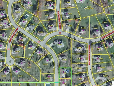


Property identifiers are numeric or alphanumeric codes that designate a specific parcel, county, or delivery point to help businesses connect property records across systems and to additional location data. Parcel numbers, account numbers, county FIPS Codes, and persistent, unique identifiers (PUIDs) are all considered property identifiers.
To access these identifiers, you could manually research the parcel number, account number, and county FIPS Code associated with a property. But at scale, that research is time-consuming and costly.
Smarty’s US Parcel Boundary Data makes property identification a whole lot easier. Instead of conducting manual research, you’ll download a Parquet, CSV WKT, GeoJSON, GeoPackage, or Shapefile file and get instant access to property identifiers for every property in a specific county or state—and more than 110 additional parcel attributes.
Want to see how it works? Request a sample file of US Parcel Boundary Data, or read on to learn what property identifiers are, how they’re used, and how you can best implement them in your existing workflows.
Table of contents
- What is a property identifier?
- Why property identifiers matter
- How property identifiers are used
- Who uses property identifiers?
- Property identifier examples, fields, and schema mapping
- Best practices for using property identifiers
- Conclusion
- Frequently asked questions about property identifiers
- What is a property identifier?
- Is a property identifier the same as a parcel identifier?
- Why does a property have multiple identifiers?
- Is a parcel number unique across the United States?
- What's the difference between a parcel number and a tax ID?
- Why are there formatted and normalized parcel numbers?
- What are alternate parcel numbers?
- How does county FIPS relate to property identification?
- Can property identifiers change?
- Can I purchase a national file of US Parcel Boundary Data?
What is a property identifier?
Property identifiers are values assigned to a specific property by county assessors, the American National Standards Institute (ANSI), and third-party data providers. Property identifiers include parcel numbers, geographic identifiers, and other property identification codes.
Why property identifiers matter
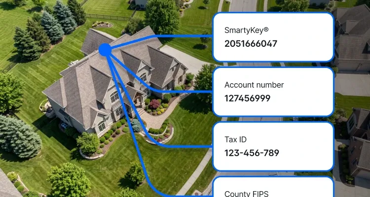
Property identifiers provide businesses with the data they need to link a property to its public property and tax records, its current and past addresses, and its county. Property identification also helps businesses identify and match property records across their internal databases.
With accurate record matching and enriched property records, businesses gain a more comprehensive understanding of a property and make more informed decisions.
How property identifiers are used
Each property identifier has its own use case, from accessing county property and tax records to blending data. In this section, we break down the property identifiers returned by US Parcel Boundary Data and how you can use each one in your workflow.
Parcel number
Parcel numbers are unique identifiers assigned by an assessor to each property within a county. Using a property’s parcel identification number, you can identify public information about a property’s owner, acreage, tax and financial history, and valuation.
Formatted vs. normalized parcel numbers
Each county establishes its own conventions for parcel number formatting. Formatted parcel numbers preserve those conventions. Normalized parcel numbers standardize them by removing characters outside A–Z and 0–9, so you can easily match property records across datasets.
Alternate parcel numbers
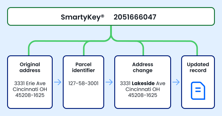
When property or county boundaries change, parcel numbers may need to be adjusted. Alternate parcel numbers help with ongoing parcel identification by maintaining a record of retired parcel numbers. With a property’s alternate parcel number, businesses can match historical property records with current ones.
State parcel number
In addition to county parcel numbers, state parcel numbers are assigned to taxable state land. Statewide parcel identifiers provide an additional way to identify and link property records.
Account number and tax ID
County recorders often utilize a Land Records Management System (LRMS) to track property ownership and registration. LRMSs use account numbers or tax IDs, rather than parcel numbers, to identify properties. Businesses rely on account numbers and tax IDs to retrieve associated property records from government systems.
County FIPS (GEOID)
County FIPS Codes are a type of numeric geographic identifier (GEOID) used to identify counties in the US. A 5-digit county GEOID combines a 2-digit state code with a 3-digit county code. The codes are standardized and maintained by the American National Standards Institute (ANSI), allowing geographic data to be matched to the correct county. County FIPS Codes can also be used to provide businesses with context for parcel numbers.
Caveats when using property identifiers
While these property identifiers have several use cases, they also come with two main limitations: a lack of standardization and the possibility of changes.
Since each county can decide how its parcel numbers are formatted, parcel numbers are only unique and standardized within their county. Counties with the same formatting conventions may have identical parcel numbers that refer to completely different properties, while counties with different formatting standards may cause issues in workflows that handle parcel numbers from those counties as the same.
Additionally, both parcel numbers and county FIPS Codes can change when property or county boundaries are adjusted. In 2025, 11 counties changed FIPS Codes, and countless properties changed boundaries as new developments split or merged parcels and as boundary disputes were resolved by local governments.
These caveats are why US Parcel Boundary Data includes an additional property identifier, SmartyKey.
SmartyKey
SmartyKey is a PUID assigned to every property address in Smarty’s database that remains constant regardless of how many times the address changes. Each property in a county- or state-level US Parcel Boundary Data dataset is returned with a SmartyKey to strengthen property identification efforts.
With a property’s SmartyKey, you can accurately identify a property record, even when it shares a parcel number with another record or when its parcel number or county FIPS Code changes.
Who uses property identifiers?
Businesses across industries can benefit from these property identifiers. Here’s how.
Real estate
Real estate companies can rely on property identifiers when researching markets. While parcel numbers can be used to find public property and tax records about a listing’s ownership, valuation, taxes, and acreage, county FIPS Codes identify a listing’s county to analyze, directing county-level market research to the right place.
P&C insurance
With parcel identification numbers, P&C insurers identify the right parcel before underwriters begin risk assessments. Then, with SmartyKey, they can relay parcel-level data to a catastrophe modeler for better risk decisions.
Finance
Financial organizations use property identifiers to match properties to public records and county FIPS Codes, which provide the appraisal, acreage, valuation, tax, and county-level data they need when evaluating potential investments.
Telecom and utilities
As telecoms and utility companies plan networks across counties, states, and countries, accurate property and parcel identification is essential. With parcel numbers and county FIPS Codes for every asset’s location, it’s easier to connect service-location information with public property records, tax records, and county-level data.
Property identifier examples, fields, and schema mapping
Now that you know what types of property identifiers US Parcel Boundary Data returns and how businesses use them, let’s break down what those property identifiers look like as output fields.
Property identifier examples
Since each county assessor follows different processes and regulations, not every parcel identifier can be returned for every property. In the table below, we’ve included the property identifiers returned by US Parcel Boundary Data for two properties.
| 2010 Royal Dr Winterville, NC 28590-9915 | 68 Ed Ledford Ln Spruce Pine, NC 28777-5415 | |
| parcel_number | 66428 | 89000834372 |
| parcel_number_formatted | 66428 | 0890-00-83-4372 |
| parcel_number_alternate_1 | 66428 | Not reported by assessor |
| parcel_number_state | 4686821161 | Not reported by assessor |
| account_number | Not reported by assessor | 555552647 |
| tax_id | Not reported by assessor | 555552647 |
| county_fips | 37147 | 37121 |
| smartykey | 1770155905 | 727079236 |
Schema mapping
US Parcel Boundary Data provides property identifiers as a downloadable Parquet, Shapefile, CSV WKT, GeoJSON, or GeoPackage file, each organized by property data point. In the table below, we outline the output field names to expect at the top of each column and the data type in which each property identification point will be provided.
| Property identifier | Output field | Shapefile output field | Data type |
|---|---|---|---|
| Parcel number | parcel_number | parcel_num | varchar |
Alternate parcel number
| parcel_number_alternate_1 | alt_parc_1 | varchar |
| parcel_number_alternate_2 | alt_parc_2 | varchar | |
| parcel_number_alternate_3 | alt_parc_3 | varchar | |
| State parcel number | parcel_number_state | par_num_st | varchar |
| Formatted parcel number | parcel_number_formatted | par_num_fm | varchar |
| Account number | account_number | acc_num | varchar |
| Tax ID | tax_id | tax_id | varchar |
| County FIPS | county_fips | cnty_fips | varchar |
| SmartyKey | smartykey | smartykey | bigint |
For a more in-depth look at US Parcel Boundary Data’s schema mapping, check out the documentation.
Best practices for using property identifiers
Ready to integrate property identifiers into your processes? Keep these best practices in mind as you build your workflow.
Keep the jurisdiction attached
Since parcel numbers are county-specific, your workflow should keep a property’s parcel number and county FIPS Codes attached. That way, you’ll be able to differentiate identical parcel numbers from different jurisdictions and avoid bad property record matches.
Preserve source and normalized values
Your workflow should also maintain both the formatted and normalized parcel identification number for a property, as normalized parcel numbers enable property record matching and formatted parcel numbers ensure you can trace those matches back to their original source.
Use alternate identifiers for matching
If your workflow matches properties by parcel number, you’ll want your matching protocols to rely on alternate parcel numbers as well as parcel numbers, state parcel numbers, account numbers, and tax IDs, so you can match outdated property records to current ones, even when county and property boundaries have changed.
Use multiple signals for record matching
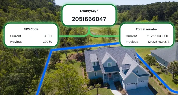
Since parcel numbers and county FIPS Codes change, your workflow can rely on SmartyKey to reliably match property records. When integrated into your workflow, SmartyKey can also tie property and parcel identifiers to verified addresses.
Conclusion
If you’re looking for a parcel boundary data provider that follows each of those best practices and then some, you’ve come to the right place. Smarty’s US Parcel Boundary Data provides property identifiers at the county or state level in downloadable Parquet, CSVWKT, GeoJSON, GeoPackage, and Shapefile formats.
With US Parcel Boundary Data, you’ll gain access to parcel numbers, formatted parcel numbers, alternate parcel numbers, state parcel numbers, account numbers, tax IDs, county FIPS Codes, and SmartyKey for every property in a specific region, enabling you to better identify and match property records, then tie those records to additional location data.
To see how property identifiers can improve your property identification workflows, download a 19,000+ address sample US Parcel Boundary Data dataset, or contact us to create a custom sample dataset.
Frequently asked questions about property identifiers
A property identifier is a unique code created and maintained by government agencies or data providers that identifies a specific property. There are several types of property identifiers, including parcel numbers, county FIPS Codes, and persistent, unique identifiers.
A parcel identifier is a type of property identifier. Parcel identifiers include formatted, normalized, alternate, and state parcel numbers, as well as account numbers and tax IDs.
A single property can have multiple identifiers, each serving a different purpose. For example, a parcel number identifies a property’s parcel, while a county FIPS Code identifies its county.
No, parcel numbers are unique only within a county or state, meaning a parcel number in one jurisdiction may be identical to a parcel number in another.
A parcel number is the property identifier assigned by a tax assessor to each parcel within a county. A tax ID is an optional, additional identifier that tracks the parcel within an LRMS.
Formatted parcel numbers maintain the formatting conventions used by a county tax assessor when assigning a parcel number. Normalized parcel numbers standardize that formatting across counties by eliminating any non-alphanumeric characters. That helps businesses match property records with parcel numbers.
Alternate parcel numbers are historical parcel numbers that were once used to identify a property, but are no longer active.
County FIPS Codes identify a property’s county and state, rather than a specific parcel. Need to find a property’s county FIPS Code? Try our county FIPS Code lookup tool!
Yes, changes to parcel numbers and county FIPS Codes follow changes to property or county boundaries.
Yes, the full US Parcel Boundary Data dataset is available to download as a Parquet file.
Was this helpful?