
What are postal codes? Meaning, formats, and how they work worldwide
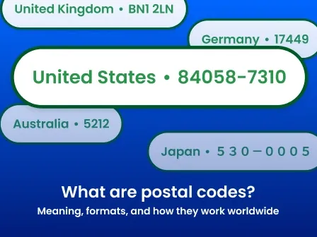


Postal codes are strings of numbers, letters, or both that help postal services sort and route mail. Their format varies by country, but their basic purpose is the same: helping an address move through the postal system more efficiently.
The world uses postal codes in different formats, and though those systems and formats vary, the common trait is that they all make the mail carrier's job a little easier and enhance workflows in ecommerce, shipping and logistics, and other enterprise operations related to location intelligence.
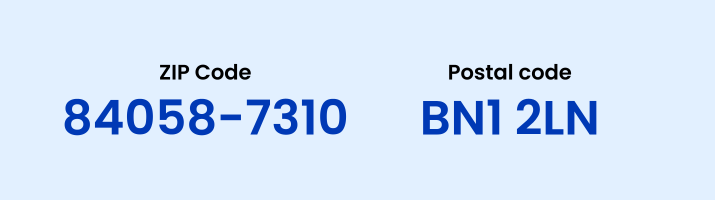
While postal codes are similar to ZIP Codes and ZIP+4 Codes, there are some key differences:
| Postal codes | ZIP Codes | |
| Where used | Countries worldwide | United States |
| Purpose | Route and sort mail | Route and sort mail |
| Format | Varies by country | Five digits, with an optional four-digit add-on |
| Characters | May include letters and numbers | Digits; ZIP+4 Codes also include a hyphen |
| Managed by | Each country’s postal authority | United States Postal Service (USPS) |
| Key distinction | General global term | US-specific postal code system |
Smarty offers tools to help you identify postal codes by country or look up a postal code format. You can try them out for free here, or continue reading to learn more about postal codes below.
Postal codes may appear simple, but their formats, placement, and precision vary widely around the world. Understanding those differences can help you format addresses correctly, improve deliverability, and avoid treating a postal code as more precise than it really is.
In this article, you’ll find even more info about postal codes, such as:
- What is a postal code, and what do they represent?
- Why do postal codes exist?
- How do postal codes work?
- International postal code names
- Postal code formats around the world
- How businesses use postal codes
- Conclusion: More than a code on an envelope
- Postal code FAQ
What are postal codes, and what do they represent?
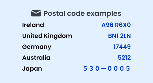
Postal codes represent a destination within a country’s postal routing system. Depending on the country, that destination may be a broad region, a city or neighborhood, a delivery route, a street segment, a large organization, or even an individual address.
That means postal codes don’t all describe locations with the same level of precision. One code may cover thousands of addresses, while another may identify a single building or delivery point.
Postal codes also should not be treated as exact city, county, state, or province boundaries. Postal authorities create them to make sorting and delivery more efficient, so their boundaries may cross or differ from the administrative boundaries businesses use for taxes, insurance, reporting, or service territories.
A postal code alone also can’t confirm that an address is complete or deliverable. It may point mail delivery toward the correct area, but the remaining address components still determine the final destination. The street name, house number, unit, locality, and country-specific formatting all matter.
For businesses, this distinction is important. A valid postal code does not necessarily mean the full address exists, that it includes the correct apartment or suite, or that it can receive mail. That’s why postal codes are most useful when they are validated as part of the complete address rather than evaluated on their own.
Why do postal codes exist?
Back when cities started to get bigger and reliable mail services became the standard, a problem emerged that made deliveries difficult.
In London, for example, there were just too many people for one mail carrier—or even one post office—to deliver to. As in any industry, meeting demand is at least partially a logistics problem: having the means and the manpower to meet the need. So the first and most obvious answer was to build more post offices and hire more postal workers.
A stronger, fuller workforce created another problem, though: How would each worker know which houses they were supposed to deliver mail to?

If Dr. John Watson lived halfway between Post Office A and Post Office B, which office would need to handle his mail?
Both locations were equally capable in terms of distance, but there needed to be a better way to automatically assign which one would take the lead for each delivery point.
To ensure that no single post office was doing more than its fair share of the labor and that all mail was handled as efficiently as possible, post offices began dividing growing cities into smaller delivery areas. These divisions were commonly called postal districts or postal zones.
Assigning numbers or letters to them made mail easier to sort and route, creating an early precursor to modern postal codes.
London introduced postal districts in the 1850s, and similar systems later appeared in other major cities.
In the United States, the Post Office Department introduced numbered postal delivery zones in 1943. Twenty years later, those local zone numbers helped pave the way for the nationwide ZIP Code system.
Postal codes vs. ZIP Codes
The primary difference between postal districts/postal zones and their more evolved cousins is coverage: postal districts existed only in cities, and only in some cities. They were neither pervasive nor systemic, though the idea of expanded and universal delivery codes began circulating as early as the 1930s. One of the earliest attempts at a nationwide postal code system was introduced in the Ukrainian Soviet Socialist Republic in 1932, but it was discontinued several years later.
The system was discontinued in 1939, but the broader idea of standardized nationwide postal codes continued to spread.
Germany had a functioning postal code system in place in 1941, despite the war, whereas the United States of America didn't implement ZIP Codes (the US version of a postal code) until 1963.
Later still, the UK didn't fully implement a nationwide postcode system until 1974.
Since then, postal codes have been the norm, with countries expanding their formats to accommodate additional areas. This is most frequently done by adding digits to the code, for example, changing from a 3-digit code to a 5-digit one, and so on.
How do postal codes work?
Today, postal codes are used extensively.
They organize addresses into routable delivery destinations. Depending on the country, a code may represent a broad region, a delivery area, a route, an organization, or an individual address.
When mail enters the postal system, automated equipment reads the code and directs it through the appropriate processing centers. It's then sent to a local post office or delivery unit, where the full street address determines the final destination.
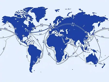
Postal-code placement also varies by country. Depending on the destination's addressing convention, the code may appear before or after the locality, on the same line as the city, or elsewhere in the formatted address, such as in Address Line 2.
International postal code names
William Shakespeare once wrote, "A postal code by any other name would smell as sweet." We may have paraphrased that just a little, but the point is this: different nations have different names for the same thing.
Just as the United States of America calls it a "flashlight" and the UK calls it a "torch," so too do postal code names vary by region. Here are some of the most popular ones:
- ZIP Codes: the "Zone Improvement Plan" Codes used in the US
- Postal codes: a generic term that can be applied universally;
- Postcodes: a variant of the above; used in multiple English-speaking nations, as well as the Netherlands
- CAP: the acronym for Italy's "Codice di Avviamento Postale", or Postal Expedition Code
- CEP: Brazil's "Código de Endereçamento Postal," or Postal Addressing Code
- Eircodes: Ireland's most recent delivery code system
- PIN codes/Pincodes: what they call postcodes in India, stand for "Postal Index Numbers code”
- PLZ: stands for "Postleitzahl", which translates to "postal code"
To learn more about international address validation and formatting conventions, check out our global address solutions pages.
Postal code formats around the world
Formats for these codes vary. However, there are some cornerstones to lay out and some generalities to offer on the topic, such as how they're used extensively by the Universal Postal Union, a UN agency.
First, let’s examine the characters used in the code. Keep in mind that the actual composition of the codes used varies from nation to nation, so not every place is going to use every character. That being said, you can expect these three kinds of symbols in a postal code, regardless of where you’re sending mail or parcels:
- The ten base characters of the Arabic decimal system (i.e., the numbers 0-9)
- The 26 letters of the basic Latin alphabet (A-Z)
- Hyphens and spaces
Most nations use just the numbers (and sometimes spaces or hyphens, with varying levels of saturation). There are some countries, though, that like to add a little complexity to their postal codes by throwing in letters, making the code alphanumeric.
Here's the list of some of the countries that have adopted or partially adopted alphanumeric codes, in reverse alphabetical order, because we like upside-down things:
- Venezuela
- United Kingdom
- Eswatini (formerly Swaziland)
- Somalia
- Peru
- Netherlands
- Malta
- Jamaica
- Ireland
- Canada
- Brunei
- Argentina
Location, location, location
The way postal codes are written is often tied to the locations they’re assigned to. Rather than randomly assigning numbers and letters, well-intended government organizations group things together for easier labeling.
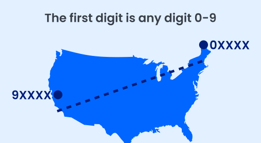
For instance, in the US, the first digit of the code (any digit from 0 to 9) indicates which region of the country the destination is in. ZIP Codes that start with "0" are located in northern New England, while those starting with "9" are associated with the West Coast, Alaska, and Hawaii.
Meanwhile, the first 1-2 characters of a UK postcode are letters that indicate the destination city or area: "L" for Liverpool, "RH" for Redhill, and so forth.
Again, the system varies from nation to nation. Postal codes aren’t always tied to administrative or geographical borders.
Sometimes they're tied to old postal zones used in big cities.
Sometimes they are strictly tied to geographic or administrative areas, such as provinces and states. Ecuador has a couple of those.
Then there are postal codes that are close to a border but not quite there; sometimes this means you’ll see ones that never extend beyond a province's borders, even though there’s more than one code within them.
In the US, ZIP Code digits reflect the postal network rather than counties. The first three digits generally identify a Sectional Center Facility or large-city area, while the remaining digits narrow the destination to a Post Office or delivery area.
However, many ZIP Codes frequently don't align with city or county boundaries because they are designed around postal delivery operations rather than administrative geography.
Postal codes in this category don't really align with the boundaries used by the rest of the nation's administrative infrastructure. They’re assigned based on wherever is most convenient for mail delivery routes.
Entity-tied postal codes
Sometimes, codes won't be tied to boundaries at all; they'll be tied to recipients. Here are a few examples:
- Post office boxes often have their own postal code, or postal code suffix (they get their own personal "+4" in the US).
- Some countries use postal codes, with each code unique to a destination address.
- Large buildings, businesses, and organizations such as universities and hospitals often have their own postal code due to the volume of mail they receive.
- Some individuals are such popular recipients that they merit a postal code all on their own: there's a unique post code in Finland (96930 Arctic Circle/Napapiiri), Greenland (2412), and Canada (H0H 0H0) reserved specifically for Santa Claus (who is known as Joulupukki to the Finnish and Julemanden to Greenland).
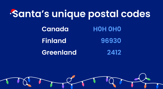
The Santa Claus example is the true exception—the others will still be tied to the destination's general geographic location.
Postal code accuracy
Divisions of postal jurisdiction notwithstanding, some codes are more accurate than others. By that, we mean some codes point to a post office or a delivery route, while some get specific enough to point to the actual house. In Ireland, the Eircode system, launched in 2015, is accurate enough to effectively replace addresses. This wasn't the intention, but the seven-character alphanumeric postcodes are each attributed to individual locations.
Ireland is unusual because each Eircode is unique to a postal address and its geographic location. An Eircode contains a three-character Routing Key and a four-character Unique Identifier, allowing it to distinguish one postal address from another even when multiple properties share similar or identical conventional address descriptions.
Most postal code systems are not precise enough to identify a single property. In the United States, five-digit ZIP Codes identify the postal area and post office responsible for delivery rather than geographic regions.
ZIP+4 Codes add four digits that identify a smaller delivery segment within the five-digit ZIP Code. Depending on the address, that may correspond to several blocks, one side of a street, a building, a group of apartments, a Post Office box section, or—in some cases—a unique delivery point or mailbox.
Just like everything else, accuracy depends on the country that developed the code.
How businesses use postal codes
Postal codes support far more than an optimized mail processing facility. Businesses use them alongside full address data to verify customer information, estimate shipping costs, evaluate service areas, analyze geographic patterns, and support fraud-prevention workflows. Because a postal code rarely provides enough detail on its own, address verification, autocomplete, geocoding, and enrichment products can help organizations turn basic address entries into more accurate and useful location data.
Concerning address placement and formatting, different countries place the code in different parts of an address. While this has nothing to do with the code's format, how it's put together, or what it means, it's perhaps more important. You don't necessarily need to know that an Eircode will get you to the doorstep of a property, or what the boundaries of a ZIP Code are. However, you should know where to place it on the envelope, and this also varies by region.
Postal-code placement is another area where country-specific rules matter. Some postal authorities place the code before the locality; others place it after. Spacing, punctuation, and surrounding address elements can also differ.
Rather than relying on a regional rule of thumb, check the destination country's prescribed format.
If you’re unsure where to include the postal code, you can check out our free global formatting guide or look up and verify the address before sending mail.
Conclusion: More than a code on an envelope
Postal codes may look like a small part of an address, but they carry a surprising amount of responsibility. They help postal authorities sort mail, guide shipments through delivery networks, and give businesses a useful starting point for understanding where an address belongs.
However, they don’t work the same way everywhere. Their formats, placement, geographic precision, and relationship to cities or administrative boundaries can vary significantly by country.
They may represent a neighborhood, a delivery route, a large organization, or even an individual postal address. They may also cross city, county, or state boundaries.
That nuance is why a postal code alone can’t confirm that an address is complete, correctly formatted, or deliverable. Businesses working with address data need to consider the full address and the country's postal rules.
Smarty helps simplify that complexity.
Our US Address Verification and International Address Verification tools can identify the appropriate postal code, standardize the address according to local formatting conventions, correct address components, and help determine whether the complete address is valid and deliverable.
You can also simplify the address verification process for your customers by trying Smarty’s US Address Autocomplete, which only suggests and autofills forms with valid addresses, or our International Address Autocomplete, which automatically standardizes addresses according to their international postal formatting guidelines, so their postal codes are in the right place for maximum deliverability.
Whether you’re checking one address or managing customer data across 250 countries and territories, Smarty helps turn address components into cleaner, more usable location data.
Getting the postal or ZIP+4 code right is helpful. Getting the entire address right is even better. With rooftop geocoding, you can even know where on a parcel the structure is located, down to a rooftop-accurate geocode.
If you're worried about whether the postal code you're using is correct, whether at home or abroad, we can help.
Postal code FAQ
Is a ZIP Code the same as a postal code?
While similar in function and use case, ZIP Codes are specific to the US and follow a structure that differs markedly from other global postal codes in both format and placement in a full address. A ZIP Code can be considered a type of postal code, but not vice versa.
How do I find my postal code?
You can look up a postal code here for free!
Why do some postal codes contain letters?
Some postal codes include letters to create more unique combinations without increasing the code's length. Letters also help postal systems identify specific regions, cities, delivery routes, or even individual buildings more precisely, depending on the country.
What information does a postal code identify?
A postal code identifies a geographic area used to sort and route mail. It’s very important to note that postal codes should NOT act as location identifiers or city or province/state boundaries.
Depending on the country, it may point to a region, city, neighborhood, street, building, or group of addresses, but not always.
Can two cities share the same postal code?
Yes. A single postal code can be associated with multiple cities, towns, communities, or rural areas. Postal-code areas also don't necessarily align with municipal or county boundaries because postal authorities design them primarily for routing and delivery.
How are postal codes used beyond mailing and mail sorting?
Bank card fraud prevention is a major use of postal codes beyond improving mailability. However, many are also used for:
- Location targeting for marketing and advertising efforts
- Shipping rates and delivery estimates
- Insurance pricing and risk analysis
- Sales tax and service eligibility checks
- Demographic and market research
- Identity verification and KYC initiatives
- Territory planning and emergency response measures
Because postal codes represent delivery areas, they’re useful for broad location analysis, but they’re not precise substitutes for a full address or exact coordinates.
Was this helpful?