
Census Tractlookup by address(US Block & Tract Data)
Smarty's US Census Block and Tract Data gives you the US Census Tract and block data you need to easily comply with governmental regulations and gain access to the critical demographic insights you need to make your organization run smoothly.
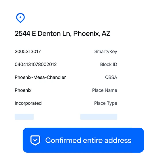
Try a census tract lookup by address live
Census tract lookup data for any address
Run a census tract lookup by address to accurately relate demographic data to specific locations using a persistent unique identifier (PUID).
Census Block Data
Use the demographic data in stable block geographies for statistical analysis and business decisions.
City Place and Name
Identify the Census Place names, IDs, and incorporated or unincorporated status of a city or town.
Get industry-leading accuracy
%
Uptime for US Census Block and Tract
M+
US addresses available
B
Addresses processed all in a day's work
Stars
Based on Hundreds of G2 Reviews
US Census Block and Tract Data gives you the precise Census Tract data you need, including
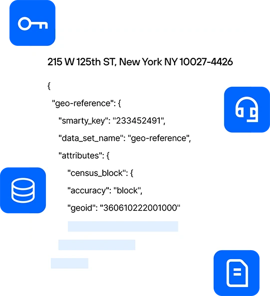
The up to 15-character Census Tract and block ID.
The county subdivision identifier and name.
The GeoID for the CBSA and name.
The precise geographic city or town an address falls within and its incorporated or unincorporated status.
How you win with Smarty US Census Block and Tract Data
Our lightning-fast API, clear documentation, and legendary support make census tract lookup by address fast, accurate, and scalable.
Enhance US Census Tract identification
Access SmartyKey®, a unique ID assigned to each location, to ensure locations tie to the correct census tract and block information.
Improve government compliance
Government regulations can be tricky to follow. Empower your organization to meet government demographic requirements with ease.
Match more Census Tracts
Smarty's US Census Block and Tract Data is connected to Smarty's US Rooftop Geocoding to ensure accurate Census data is returned for superior data modeling.
Identify locational demographics
Append the locational demographic and economic information in each Census Tract to your data for better business decisions.
Streamline data aggregation
With 210+ million US addresses in one place, you can reduce manual entry by using Smarty's US Census Block and Tract Data.
Expand with confidence
Improve your data accuracy and quality by only using verified and standardized addresses with your Census Tract data.
What industries are using US Census Block and Tract Data?
Banks and financial institutions
Ensuring compliance with governmental regulations can pose challenges for the banking and mortgage industry. Regulations such as the Home Mortgage Disclosure Act (HMDA), Community Reinvestment Act (CRA), and oversight from the Federal Financial Institutions Examination Council (FFIEC) necessitate meticulous maintenance of census tract data. Smarty provides comprehensive access to accurate census block and tract data, enabling preparation for upcoming audits with confidence.

Healthcare providers
Staying compliant with Community Health Needs Assessments (CHNA) and the Affordable Care Act (ACA) can be tricky and tedious without an easy and accurate way to access US census tract data. Smarty's US Census Block and Tract Data census tract data can help you pass your audit with flying colors every 3 years and give you critical insights into the health needs of a community to tailor your services to the surrounding neighborhoods.

Real estate technology
Using Smarty's US Census Block and Tract Data, real estate professionals can connect essential Census demographic, economic, municipal, and other data to provide their clients with tailored homebuying opportunities based on their needs for jobs, schools, transportation, and other services.

Super-fast census tract lookup API
Get the correct census tract the first time. Smarty's US Census Block and Tract Data stands on top of our already hyper-accurate US Rooftop Geocoding. When you enter an address, we instantly perform a census tract lookup and return the correct tract with verified accuracy. Additionally, each of the returned census data points is accompanied by an accuracy rating, giving you a transparent view of the data you get back.
Getting the census tract data is one thing, but being able to relate that information to addresses and other crucial tools you're using is something else entirely. SmartyKey is a persistent unique identifier (PUID) assigned to every address in the United States. With the SmartyKey, you can easily and accurately tie the census tract data back to a location despite address changes.
When you reach out to our support team, they answer promptly. It's that simple. Smarty's support team comprises knowledgeable experts — no novices, no tiers, and no time-wasting scripts. Try us, and you'll agree that our unlimited, free support is better than other companies' paid support.
Packed with examples and sample code, our intuitive documentation helps you get up and running before you can shamelessly shout, "I love Smarty's SDKs!" Read up on best practices and discover some of our pre-built open-source tools.
How others are using Smarty

Build cleaner insurance data and faster workflows
Improve data accuracy and speed quote-to-bind with better address tools.

Fire and Weather Risk Modeling
Rooftop-level geocoding provides the precise location data needed for determining wildfire and weather risk exposure.

Boost healthcare data quality for immunization tracking
Used address validation to standardize, validate, and geocode addresses.

FAQ
Smarty's US Census Block and Tract product has two easy ways to look up census tract and block information. First, suppose you need a simple, lightning-fast API to process many census tract lookups daily. In that case, Smarty's Address Enrichment API is easy to use and can process millions of addresses at industry-leading speeds. Second, you can use our census tract lookup tool to find the census tract ID, CBSA, place, and block ID individually.
A census tract is a small, relatively uniform, and stable area used for demographic analysis, typically containing 1,200 to 8,000 people. Each census tract provides detailed data on population characteristics, crucial for businesses and organizations in making informed decisions and tailoring strategies to specific communities.
The easiest way to find a census tract for an address is through a census API like Smarty's. Smarty's US Census Block and Tract API provides a simple way for banks, lenders, real estate agents, and healthcare providers to access census tract and block information.
A Metropolitan Statistical Area (MSA), also called a Core Based Statistical Area (CBSA), is a geographic region with a high population density at its core and close economic ties throughout the area. It typically encompasses one or more urban cities and their surrounding communities, used for statistical purposes to analyze urban and suburban dynamics.
More FAQ
Select a category to see more information about a certain topic.