How to find latitude and longitude of an address
For many companies, an address data solution without geocoding capabilities is no better than a cake with no frosting. Sure, you can still eat the cake, but it’s a little dry and a lot unsatisfying.
Geocoding is like frosting, it takes address data to the next level by allowing you to find latitude and longitude of an address in just a couple of clicks and keystrokes.
Think of this article as an FAQ for all your coordinate-related questions. We’ll cover everything from how to find latitude and longitude of an address, to the different levels of geocoding accuracy, to evaluating the ROI of geocoding.
Gather your ingredients. It’s time to answer:
- What is the latitude and longitude of a location?
- Why do businesses care to find the latitude and longitude of an address?
- Can I find the latitude and longitude of street addresses around the world?
- How is geocoding data kept private & secure?
- Why is it difficult to determine latitude and longitude by address?
- What is the ROI of automation?
What is the latitude and longitude of a location?
Latitude and longitude is a geodetic system used to measure the exact position of a selected location, such as a landmark, street address, or place name. Latitude measures how far north or south a location is from the equator, and longitude calculates how far east or west it is from the Greenwich meridian, also known as the prime meridian.
Latitude and longitude can be formatted as sexagesimal coordinates, which are measured in Degrees, Minutes, Seconds (DMS), or using decimal format, which is measured in decimal degrees—a simpler unit created to better convey GPS coordinates to GPS systems like Google Maps.
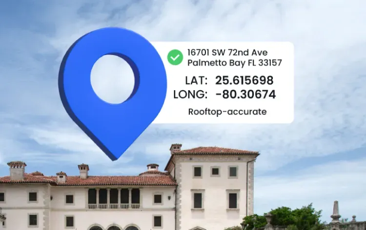
As sexagesimal coordinates, the latitude and longitude of Smarty HQ is 40° 16' 10.9014" N, -111° 42' 47.3688" W. In decimal format, it’s 40.269695, -111.713158. Coordinate pairs in the latter format are also referred to as geocodes.
Geocodes can be used to map coordinates, meaning anytime you see a pin on a digital map—like after searching the address of a bakery in the Google Maps app 🤤—you’re looking at a geocode (but maybe not the most accurate one…take a look at how Smarty and Google differ.) Beyond navigation and routing, geocodes can be used to improve everything from spatial analysis to risk assessment.
Why do businesses care to find the latitude and longitude of an address?
With rooftop-accurate latitude and longitude for addresses, companies can boost operations and make critical decisions with the confidence of a head pâtissier. Let’s break down how companies in four different industries use the latitude and longitude of addresses.

Healthcare
Using rooftop-level geocoding to pinpoint the latitude and longitude of a location down to secondary designators like apartment, suite, unit, or building number, healthcare professionals can better reach patients in need for home health visits.
For Curatus, a healthcare technology company, the latitude and longitude for address information, such as up-to-date provider locations, was essential to maintaining compliance with federal laws, as well as keeping large datasets of addresses clean and verified. When paired with address verification, health tech companies can reach even greater levels of data accuracy.
Healthcare companies researching the effect of social, physical, and environmental factors on public health utilize data points, like US Census Tract information, that are tied to specific locations. With geocoded patient addresses, retrieving only the most relevant information is easy as pie.
Insurance
For insurance companies, the exact coordinate pair of an insured property and the current location of nearby hazards lead to lightning fast and insanely accurate risk assessment. After calculating the precise distance between a property and potential risks, underwriters can analyze risk and price policies with more accuracy.
In addition to boosting both customer confidence and satisfaction, knowing the latitude and longitude of addresses increases compliance.
While street names and 9-digit ZIP Codes constantly change, the latitude and longitude of street addresses remain consistent. By tying insured properties to the latitude and longitude of street addresses, rather than street address or ZIP Code, insurers can prevent underwriting guideline violations and keep their data gleaming like a glazed donut! 🤣
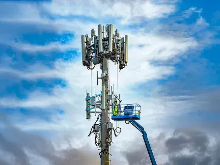
Telecom
Knowing how to find latitude and longitude of an address is essential for telecom organizations concerned with the precise, current location of a property.
With latitude and longitude by address, telecoms can pinpoint properties with rooftop-level accuracy. Access to the latitude and longitude of a location leads to better network planning, maintenance, and servicing.
Plus, with reverse geocoding—a coordinates converter tool that turns lat and long into addresses—telecoms have a clearer understanding of where their assets are located. When on-site maintenance is needed, technicians can find service locations with ease.
To top it off, more accurate latitude and longitude for addresses means better data blending. Since the latitude and longitude of addresses will always remain consistent, datasets with addresses tied to geocodes, rather than addresses, will be able to combine more seamlessly than ingredients in a stand mixer. 😉
Can I find the latitude and longitude of addresses worldwide?
Whether a healthcare, insurance, telecom, or real estate company is based in Sydney, Montana or Sydney, Australia, the benefits the geocode process offers remain the same.
With Smarty’s International Geocoding, you can find latitude and longitude of an address in all 250 countries and territories, rather than buying geocoding licenses for different countries from different providers.
With each global geocode, we return an accuracy rating that clearly defines its precision level. For countries including Canada, the United Kingdom, Australia, and Belgium, our best-in-class geocodes come with unmatched location accuracy.
Better yet, International Geocoding is equipped with International Address Verification (and they work together better than milk and cookies.) Since each country uses its own address format, validation ensures that your global address data is correctly formatted before geocoding.
How is geocoding data kept private & secure?
Smarty’s geocoding API was built to keep customer information safe. We’ll securely encrypt your data to ensure complete anonymity, meaning you can rest easy knowing your data won’t be distributed, sold, or abused in any way.
Our US geocoding API is equipped with SmartyKey, a persistent unique identifier (PUID), that creates an additional layer of privacy for customers. Instead of assigning data—like the latitude and longitude of addresses—to customers’ addresses, we’ll tie it to randomly generated PUIDs to keep customers’ Personally Identifiable Information (PII) safe.
Why is it difficult to determine latitude and longitude by address?
Finding the latitude and longitude for address data isn’t always a piece of cake. Here’s three potential complications to keep an eye out for.
False positives
Geocoding matches an address to lat long coordinates. When that address includes typos and misspellings because it isn’t standardized, failures in the geocode process matching can follow.
Geocoding API worthy of a Michelin Star will flag incorrect addresses for manual review, preventing incorrect latitude and longitude by address validation, rather than returning false positives.
However, some tools are equipped with overly aggressive matching algorithms. These tools will alter parts of an incorrect address until it matches a valid address. While the geocode returned is correct for this new, valid address, it could be over a mile away from the customers’ actual address. 😱
Mappable invalid addresses
Mappable but invalid addresses can stir up trouble for geographic tools. While a navigation API like Google Maps would locate where these addresses would be, they don’t refer to real, mail-receiving structures that have been recognized by an official mail service.
If invalid addresses returned by APIs like the Google Maps Platform API are used to find the latitude and longitude of an address, a geocoding too
l that doesn’t flag unverified addresses could return coordinate pairs referring to a structure that doesn’t exist, leading to failed deliveries, mispriced policies, and other costly errors. 😬
Parcel-centroid geocodes
Geocodes can have different levels of accuracy. ZIP-centroid geocodes, for example, refer to a segment of a postal delivery route, which typically contain 10–20 addresses. This level of accuracy provides a cost-effective solution for finding the approximate location of addresses.
Parcel-centroid geocodes provide another level of accuracy. Using the known boundaries of a property, parcel-centroid geocodes identify the latitude and longitude coordinates that refer to the property’s center. However, structures are rarely built in the exact center of a property, so the accuracy of these geocodes can be half-baked.
That’s why rooftop geocodes exist. For large or irregularly shaped parcels, the distance between a parcel-centroid geocode and a structure can be embarrassingly far. Rooftop-level geocodes ensure that you know exactly where the structure is located.
Challenges arise when imprecise parcel-centroid geocodes are passed off as hyper-accurate rooftop-level geocodes. For example, inaccurate latitude and longitude of addresses can lead to flawed risk-assessments, meaning a world of hurt for property insurance companies.
Clearly, the geocode process comes with its challenges, but there’s no need to lose your sprinkles. Smarty’s geocoding API will flag incorrect addresses long before they create false positives and will never return parcel-centroid geocodes.
What is the ROI of automation?
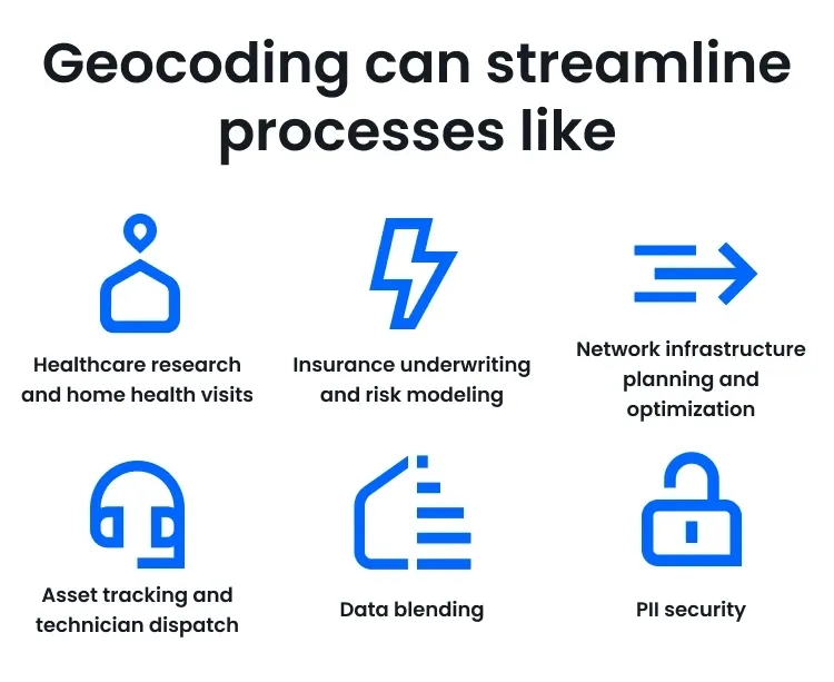
Stop wasting time manually calculating latitude and longitude by address. Smarty will go the extra mile for you. Geocoding can streamline processes like:
- Healthcare research and home health visits
- Insurance underwriting and risk modeling
- Network infrastructure planning and optimization
- Asset tracking and technician dispatch
- Data blending
- PII security
To see the ROI geocoding has to offer your company, give a 42-day slice of our free trial a try. Have questions? Talk to a living, breathing person who’d be thrilled to sweeten your day with real-time answers.
Was this helpful?