What are geocodes and how to geocode addresses
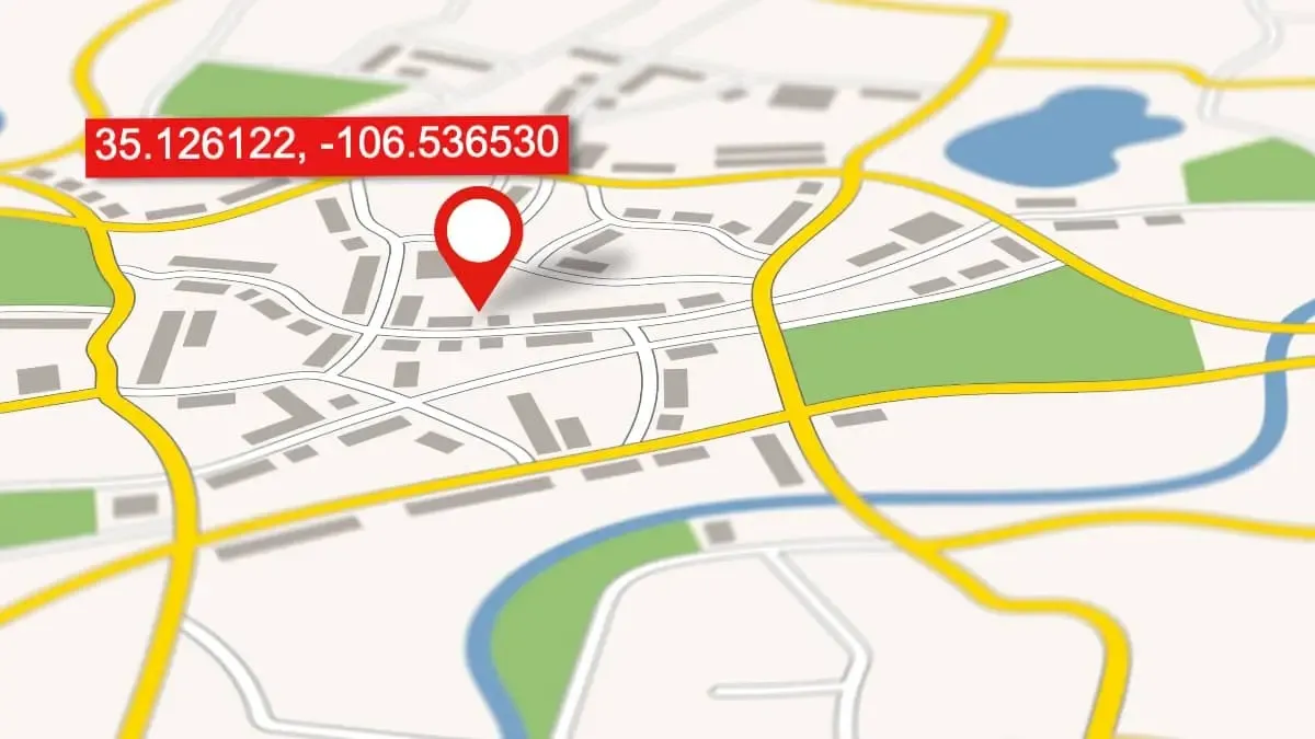
A Geocode is a set of latitude and longitude coordinates that represents a specific geographic place such as a landmark, street address, place name, or location. Geocodes are plottable on maps and have applications in navigation, routing, spatial analysis, and insurance risk analytics, and more.
Geocoding (or address geocoding) is simply the process of identifying the best available geocodes for street addresses.
To geocode street addresses into lat-long coordinates, you'll need to select one of the many types of geocoding tools. For instance, geocoding API services allow developers to integrate geocoding software directly into their websites, programs, and applications.
Depending on capabilities, a batch geocode tool enables you to process hundreds to billions of addresses at a time from data in Excel spreadsheets or CSV files. Single-entry address geocode tools allow you to get geocodes by completing a web form. Here are a few of the tools Smarty offers to geocode address data.
In this article, we'll cover:
- Video: Geocode basics
- How accurate is geocoding?
- How are geocodes used?
- How do I find geocodes for addresses?
- Reverse geocoding
- Geocoding with the Google geocoder
Video: Geocode basics
A “geocode” is just an easier way of saying “a set of latitude and longitude coordinates”—much in the same way that “geocaching” is just an easier way of saying “geographic coordinate-based scavenger hunt.”
So, if geocodes are the lat-long coordinates, then geocoding is the process of entering a location's description from one format (like a precise street address) and getting that location's specific lat-long coordinates as the output. Geocoding is performed in numerous ways. These methods differ in speed, cost, accuracy, and precision.

How accurate is geocoding?
Asking, “How accurate is geocoding?” is like asking, “How fast are cars?”. Neither question is answerable until we make the question more specific. For example, asking a more precise question like, “How fast is a Ferrari F40’s 0–100 km/h?” We can answer, “4.1 Seconds.”
A more precise question about the accuracy of geocoding would be, “How accurate can geocoding be?” or “What geocode accuracy levels currently exist?” Those are questions worth answering. Let's begin by discussing 4 common types of address geocode accuracy and one bonus accuracy type.
ZIP+4 Code geocodes
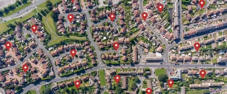
ZIP+4 Codes represents a postal delivery route segment within a larger ZIP Code that generally contains 10-20 addresses. The base of the ZIP+4 level geocode is simply the approximate center of that route.
This makes ZIP+4 Code geocodes accurate to about the block level of the desired address and would look similar to the image if the ZIP+4 Code geocodes were plotted on a satellite image.
ZIP+4 geocodes are useful when you only need the approximate location of addresses without needing to know precise rooftops or parcels.
Interpolated geocodes
You may have heard of interpolation before, likely used by a math teacher. Interpolation isn't just useful for high school math classes, though. It's also used in other practices — like geocoding.
Interpolation adds speed to the geocoding process even though it is not the most accurate approach. Despite the complexity of the math involved, the concept itself is surprisingly simple, and it works like this:
Take a random street. For simplicity's sake, we'll say a residential street that terminates in intersections at each end. Now let's suppose we have two geocodes that are near the addresses on the street we want to know about.
The 2 known geocodes reference both ends of the street at the intersections. Once we have this information, we can use math to determine what's in the middle. When we use interpolation, we say, “Well, we start with point A, and we end with point D, so in between must be point B and point C.”
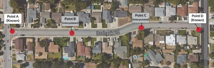
Fortunately, this method of determining geocodes is a process that can be automated by way of computer programs.
When we use math to determine where point B and point C are between point A and point D, the math puts the geocodes at regular intervals and set patterns, which is not necessarily the way that homes and businesses are built. The fact is, people put buildings wherever they want.
The precise rooftop geocode of a home may be far different from the interpolated geocode for that same home. The difference between the two geocode types becomes more pronounced in rural areas with larger lot sizes. When we use interpolation to create geocodes, we're creating geocodes that are "street-segment" accurate, but not "rooftop accurate."
Parcel centroid geocodes
Parcel centroid geocodes are calculated by taking the known boundaries of a property. Then, you approximate the geocode in the center of the parcel. Hence, the name “parcel centroid.”
Parcel centroid geocoding tends to be more expensive than ZIP+4 or interpolated due to the additional city and county data needed to calculate the geocodes, but it still lacks precision.
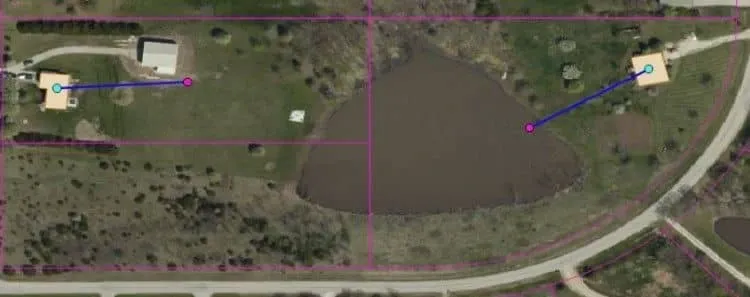
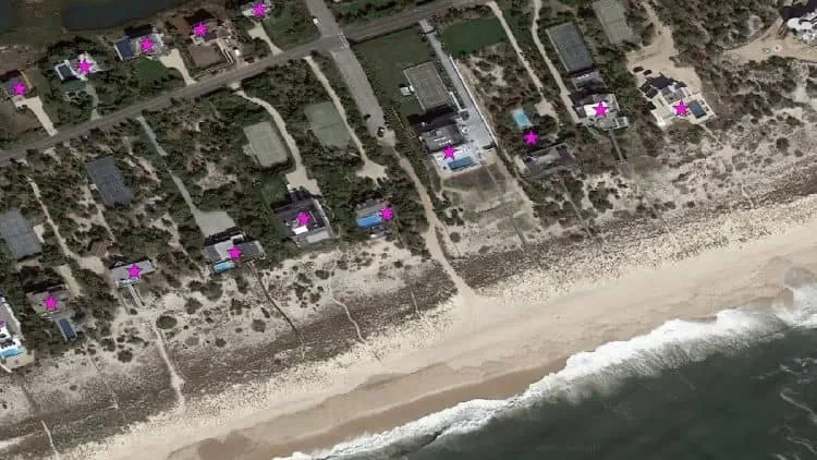
The purple markers on the image are parcel centroid geocodes provided by the Google Geocoding API. Notice how Google placed the geocode in the pond? If you understand how Google calculated this geocode, the problem with parcel centroid geocodes becomes apparent.
Homes and other types of primary structures are rarely built in the exact center of their parcel. A goal for many geocoders is to hit the rooftop of the primary structure as frequently as possible.
An Achilles' heel for how parcel centroids are determined, is that they are a LITTLE inaccurate for small parcels, NOTICEABLY inaccurate for medium-sized parcels, and EMBARRASSINGLY inaccurate for large parcels.
If the primary structure isn't at the dead-center of the parcel, the distance between the rooftop and the centroid geocode inevitably becomes more significant with each additional square foot of the parcel. If you need to pinpoint the rooftop of the home, knowing the center of the parcel isn't adequate.
Rooftop geocodes
Having exact matches for a primary structure on a parcel holds high value. In the case of insurance quotes, city planning, telecommunications, and hundreds of other use cases, those dozens or hundreds of feet can be the difference between low and high liability. That is why rooftop geocoding exists.
Rooftop geocodes start with the parcel centroid geocode as the reference, which is then refined using additional data points and calculations to match the geocode with the actual rooftop of the primary structure on the parcel. The more precise the geocode, the more expensive and difficult it is to obtain.
When looking for geocoder service providers, never trust that geocodes are truly “rooftop accurate” just because the provider says they are. Unscrupulous providers will often slap the “rooftop accurate geocodes” sticker on geocodes that are only parcel centroid accurate.
These providers count on you not checking the accuracy of their geocoder thoroughly before committing.
To ensure you are getting the accuracy you need, test any geocoder you are considering with many parcels. Be sure to include large and irregular properties as well as suburban and rural plots in your testing.
Bonus: Subaddress geocodes
SubAddress Geocodes (or apartment geocodes) are geocodes that are even more accurate than rooftop geocodes since they are specific to individual apartments, suites, units, buildings, etc. within a structure, address, or parcel. Smarty provides subaddress geocoding for US addresses. See how Kibage uses address validation and apartment geocoding to better serve their customers.
Smarty provides both true rooftop geocodes and subaddress geocodes.
What level of geocoding accuracy do you need?
ZIP+4 and interpolated geocodes are a lower price and lower precision. This makes them cost-effective for certain big-picture, zoomed-out, large-scale analysis, types of applications.
Rooftop-level geocodes are a higher price and far higher precision. This makes them cost effective for applications where hyper accuracy matters.
Parcel centroid geocodes are a higher price and lower precision. This makes them cost effective for only a few use cases.
In other words, parcel centroid geocodes are like a car that is also a boat. While it is a neat concept, an amphibious car is expensive and ends up being a poor quality car and a poor quality boat.
Who wants the worst of both worlds? For that reason, Smarty does not offer parcel centroid geocoding. We offer hyper-accurate United States Rooftop Geocoding. Where rooftop geocodes are not possible, we provide ZIP+4 geocodes. We also offer international geocoding in 250 countries and territories. Accuracy depends on the quality of data available in each country and we offer DeliveryPoint accurate geocodes in many countries.
How are geocodes used?
Geocoding is used whenever someone needs to know the precise position of something on earth. We could write a book about what geocoding is used for but here are three examples to get you thinking.
A restaurant franchise wants to send a coupon by mail to 300,000 addresses in a metropolitan area. The restaurant has ten nearby franchise locations and the company wants to print the address of the nearest location to each household.
By geocoding all the addresses in the area, they can easily determine which restaurant address should be printed on each coupon. Less precise ZIP+4 geocodes would work here.
An insurance underwriter needs to know exactly how far a home is from a nearby river. In this case, the home is on a 100-acre (40.469 ha) farm. A parcel centroid geocode indicates the home is 750 feet (0.23 km) from the river and would result in a lower risk assessment and a quote that underestimates the liability.
A true rooftop geocode reveals that this home is built 20 feet (6.1 m) from the river. Knowing the home’s actual distance from the river leads the insurance company to an accurate risk assessment and a correct quote. A rooftop geocoder gives the competitive edge in this case. Here is how one insurance provider uses Smarty for risk analytics insurance geocoding.
A telecommunications company in the United States wants to understand if its customers are well covered with their new network upgrade. The company wants to ensure customers will have adequate signal strength.
By directing their signal to structures rather than empty land or parking lots they create happier users who don’t have to wander into their backyard or parking lot to watch YouTube videos. Rooftop geocodes would be needed in this application.
How do I find geocodes for addresses?
This is an easy question to answer. To perform a geocode lookup, you simply need to enter a complete address into a geocoding service. You can use the hyper-accurate Smarty United States Rooftop Geocoding service. You can also use our less precise ZIP+4 accurate geocode service. Either geocoder can provide you with geocodes blazing fast.
Reverse geocoding
While geocoding helps you find latitude and longitude coordinates for an address if you already have a geocode, you may need to transform it back into a human-readable address. After all, geocoding shouldn’t be a one-way street.
This is a process called reverse geocoding and is worth learning more about. This is useful in cases where you need to identify the address of the point on a map. Such as the building address, home address, or landmark. Integrating your software with a reverse geocoding API gives you the flexibility to reverse geocode exactly the way you need.
Geocoding with the Google geocoder
Sometimes services like Google will geocode locations that don't exist.
Places like Google and Bing usually do parcel or rooftop-level accuracy on their geocodes. Map services do this, so they can give you GPS directions to a location. It's helpful when you want to know how to drive to where you're going.
What Google's geocoding API doesn't do is check for the validity of a complete address, as Smarty does. That means if conditions aren't perfect (you entered the address incorrectly, the area isn't well mapped, etc.), Google may drop the pin on the map when it should be telling you it couldn't find the address. You can first run it through Google's address validation service, but that comes with limitations.
So if you're counting on a mapping service to provide you with geocodes, you may find yourself requesting geocodes to a place that's no longer an active mailing address, isn't one yet, or isn't a real address at all. As many have already experienced, this is a problem even if you're looking for physical addresses rather than geocodes.
Since Smarty's first love is address standardization and address verification, it's the first thing we check. And if the place doesn't exist, we won't give you the geocodes for it.
Why did I care about all of this long enough to read to the end?
So at the end of the day, Smarty's geocodes are hyper-accurate, and they're a bunch quicker than the competition. And best of all, by combining geocoding with address validation, you can be sure the data we give you is clean and reliable.
Smarty's rooftop geocodes are offered as an upgrade to our US Street API. Our documentation contains SDKs for many languages and tons of sample code to get your integration into production quickly. Try the US Rooftop Geocoding live API.
Was this helpful?

