
Is Tornado Alley moving? Yes, and insurers should care.


Tornado Alley has always sounded like the kind of place you’d avoid on a road trip.
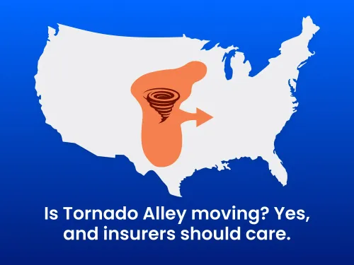
Tornado Alley was given this name because twisters are 10x more likely to occur in this region of the US each year. Historically, the term has pointed to the Great Plains states where tornado activity has been especially common, including:
- Texas
- Oklahoma
- Kansas
- Nebraska
- The broader Great Plains region
However, scientists have discovered an interesting plot twist: Tornado Alley is not staying neatly inside its old stomping grounds.
Research shows tornado activity has been shifting eastward, named “Dixie Alley,” with more tornado risk showing up across parts of the Southeast, Mid-South, and lower Ohio Valley. That includes states like Arkansas, Louisiana, Mississippi, Alabama, Tennessee, Kentucky, Missouri, Illinois, Indiana, and parts of the surrounding region.
Even though drier conditions and increased moisture are subtly moving this path of destruction to other states like Florida, Louisiana, Arkansas, and Kentucky, many insurers continue to price policies as usual.
This is more than an upsetting weather story. It’s also an exposure threat.
More tornadoes are affecting places with denser populations, more trees, more nighttime events, more manufactured housing, different building practices, and communities that may not have grown up thinking of themselves as “tornado country.”
The tornado map is changing, but many risk models, underwriting workflows, and customer expectations may still be anchored to the old one.
That creates 3 big problems for insurers:
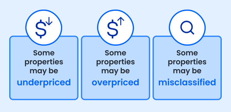
- Some properties may be underpriced because they sit outside the traditional tornado-risk mental map.
- Some properties may be overpriced because legacy assumptions don’t reflect the most current, precise view of risk.
- Some properties may be misclassified entirely because the system is pricing an address string, ZIP Code, parcel centroid, or approximation instead of the actual structure being insured.
And that last one is the real funnel cloud in the room.
Because insurers don’t insure ZIP Codes.
They don’t insure address strings.
They insure physical structures sitting in very specific places.
When tornado risk is shifting, “close enough” location data gets expensive fast.
In this blog, we hope to be able to highlight the property data and insurtech available to you so that you can more accurately price policies, improve the customer experience, protect your company from legal exposure, and get ahead in the market.
- Why property data matters more now than ever
- Why data needs a PUID
- How insurers can combat shifting weather risk
- Executive implications: How better data pays for itself
- The takeaway: Tornado Alley is shifting, and insurers need to adapt
Why property data matters more now than ever
A validated address confirms that an address is real, standardized, and formatted correctly.
But for insurance risk, address validation is only the beginning.
A valid address can still point to the wrong structure, the wrong parcel, or the wrong hazard context. That distinction matters when a few meters can change a property’s relationship to flood zones, wildfire exposure, hail patterns, roof vulnerability, local building codes, replacement costs, and storm history.
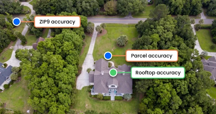
For tornado and severe convective storm risk, precision counts because exposure is highly location-dependent.
Two homes in the same ZIP Code can have very different risk profiles based on construction type, roof characteristics, age, square footage, parcel placement, surrounding structures, building elevation, and proximity to past storm paths or modeled hazard zones.
For this reason, property data should become an underwriting infrastructure, because it helps to highlight those differences and provide location context based on facts rather than speculation or even information provided by the insured.
Better property data can help insurers understand:
- Whether the insured structure is residential, commercial, multifamily, or mixed-use
- Roof type, construction type, year built, and square footage
- Parcel boundaries and property characteristics
- Whether the geocode points to the rooftop, parcel, street, or ZIP9
- Whether secondary address data is needed to identify the correct unit
- Whether the location has changed, merged, split, or appeared under multiple alias locations over time
That’s especially important as severe convective storms continue driving major losses. Swiss Re reported that severe convective storms, including tornadoes, hail, and heavy rain, caused $42B in global insured losses in the first half of 2024, with 12 U.S. storms each causing $1B+ in losses. Tornadoes may be the most dramatic part of the conversation, but they often travel with hail, straight-line winds, and heavy rain, and those storms are also increasingly expensive for insurers.
The business problem is simple: when risk moves faster than your location data, pricing discipline gets watered down.
Why data needs a PUID
A property needs a stable identity.
And when addresses change, it can be hard to know where to go for location stability that a risk profile can depend on.
Street names can change. ZIP Codes can shift. Units can be added, merged, or omitted. Alias locations can appear across systems. Public records, policy systems, claims systems, vendor datasets, and catastrophe models may all refer to the same physical place in slightly different ways.
That makes any address, or its components, a weak master key.
A persistent unique identifier, or PUID, solves that problem by tying data back to the same location over time. SmartyKey®, Smarty’s PUID, connects a location to a stable identifier even when the address or address components change.
That matters for insurers because risk analysis is not a one-time event. You need to quote, bind, renew, re-rate, model, audit, and sometimes litigate decisions tied to the same property. If every new analysis requires re-matching the same messy address data, teams lose time, introduce inconsistency, and create opportunities for pricing errors.
With a PUID, insurers can connect and preappend:
- Validated addresses
- Rooftop geocodes
- Parcel boundaries
- Property characteristics
- Third-party hazard data
- Claims history
- Policy records
- Catastrophe model outputs
- Fraud signals
- Renewal analysis
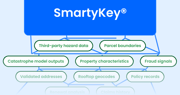
All under one durable location key.
That means underwriting, actuarial, claims, product, and data teams can work from the same understanding of “this exact place,” not multiple slightly different versions of the same address.
How insurers can combat shifting weather risk
Insurers can’t stop Tornado Alley from wandering east, but they can do some things to strengthen their intelligence workflow.
1. Standardize and validate the address first
Most insurers already do this, but if you aren’t, start by confirming that the address is real, standardized, and complete. This helps reduce bad inputs before they reach underwriting, rating, analytics, claims, or customer communication workflows. Provider data accuracy matters too, so make sure that the provider you choose to do this step knows how to avoid false positives and is transparent when they change data in order to obtain a match.
A clean address is still foundational. It just isn’t the finish line.
(PSST! Smarty’s US Address Verification comes with our built-in PUID at no extra cost to you.)
2. Use rooftop-level geocoding as the baseline, then connect external hazard layers
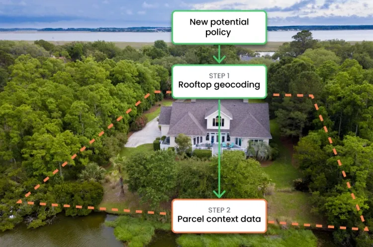
Parcel-level, street-level, or ZIP-level geocoding can be too broad for risk decisions.
For insurance, the question should always be, “Where is the actual structure and parcel we’re insuring?”
Rooftop geocoding helps identify the precise latitude and longitude of the building, not just the center of a parcel or a nearby street segment. It also provides up to 55 additional metadata points to provide even more context around an address, such as RDI, DPV, precision confidence, and more. That precision helps insurers connect the correct structure to the correct hazard context.
Weather risk data is only as good as the location it’s attached to.
If a risk layer is connected to the wrong geocode or structure, an overly broad parcel centroid, or a vague ZIP-level point, the output may look scientific while quietly producing the wrong decision.
3. Add parcel and property context
Once you know where the structure is, you need to know more about the structure itself.
Property data adds context that a coordinate alone can’t provide. A rooftop point tells you where the structure is. Property data helps explain what the structure is made of, how it may perform under severe weather, and how it should be evaluated.
That includes attributes like construction type, square footage, building use, property value, roof age and characteristics, and other parcel-related details.
You can see a full list of property data attributes provided by Smarty here.
4. Preserve location identity over time
Use a PUID to maintain continuity across address changes, vendor datasets, model reruns, claims analysis, and renewal workflows.
This is especially important as insurers revisit assumptions in regions where tornado and severe convective storm patterns are changing. A clear portfolio view depends on connecting the same property across its policy history, claim activity, and future risk models.
And blurry isn’t a great look for risk.
Additionally, the PUID provides a streamlined experience for you and your customers as you’re able to preappend that data in perpetuity with the right provider, assisting in cutting down on form abandonment and guesswork from your insureds.
Executive implications: How better data pays for itself
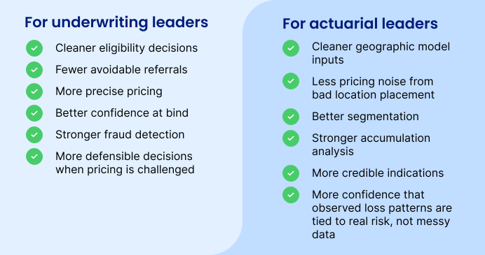
For underwriting leaders, better location intelligence can mean:
- Cleaner eligibility decisions
- Fewer avoidable referrals
- More precise pricing
- Better confidence at bind
- Stronger fraud detection
- More defensible decisions when pricing is challenged
For actuarial leaders, it can mean:
- Cleaner geographic model inputs.
- Less pricing noise from bad location placement.
- Better segmentation.
- Stronger accumulation analysis.
- More credible indications.
- More confidence that observed loss patterns are tied to real risk, not messy data.
For executives, it can mean something even bigger: location data moves from operational utility to core risk infrastructure, boosting ROI, brand recognition, and organizational reputation.
Severe convective storm losses are not theoretical.
They’re already hitting balance sheets.
When storms move into regions with more people, more structures, and different preparedness levels, the difference between “mostly right” and “pinpoint precise” can show up in loss ratios, customer experience, regulatory scrutiny, and competitive positioning.
Better data pays for itself by reducing avoidable leakage and rework. It also helps insurers make pricing decisions they can explain.
That’s critical. As weather risk changes:
- Customers want fair prices.
- Regulators want a defensible methodology.
- Executives want profitable growth.
- Underwriters want confidence.
- Actuaries want cleaner inputs.
- Claims teams want fewer surprises.
Precise location intelligence supports all of these groups and more.
Not because it magically predicts the weather, but because it makes sure the right risk is attached to the right place in times of disaster.
The takeaway: Tornado Alley is shifting, and insurers need to adapt
Tornado Alley is now part of more than just the strip of the Great Plains. The risk is spreading eastward, and the insurance implications are serious.
The carriers that adapt fastest will be the ones that stop relying on broad geographic assumptions and start treating every insured structure like what it is: a unique physical risk in a specific place with important context.
That means validated addresses are not enough.
Insurers need rooftop geocoding, parcel context, property data, hazard data, and a persistent location identifier that keeps everything connected over time.
Smarty can help insurers make that shift.
We help insurers connect cleaner address data to the real-world structures and risk signals that underwriting and actuarial decisions depend on.
So that when Tornado Alley moves, your data won’t just stand still and watch.
Was this helpful?