ZIP Code™ lookup - What are ZIP Codes & how to find them

A ZIP Code is a 5-digit number that specifies an individual destination post office or mail delivery area. ZIP Codes determine the destination of letters for final sorting and delivery. Each ZIP Code designates a collection of delivery routes used by mail carriers and areas serviced by the USPS.
The term "ZIP" in ZIP Code stands for "Zone Improvement Plan."
ZIP Code Lookup | What Is My ZIP Code?
It’s easy to perform a USPS ZIP Code lookup. Choose an option below for those asking, "What is my ZIP Code?"
| Lookup ZIP Code for an address | Lookup ZIP Codes by city name | Lookup city names by ZIP Code |
|---|---|---|
In this article, we'll cover:
- ZIP Code lookup | What is my ZIP Code?
- What is a ZIP Code, and how do ZIP Codes work?
- How to read a ZIP Code
- ZIP Codes are lines; not shapes
- Elevated ZIP Codes - The next generation
- Conclusion
What is a ZIP Code, and how do ZIP Codes work?
ZIP Codes are 5-digit numbers developed by the United States Postal Service to represent individual post offices across the United States. "ZIP Code" is the name of the postal code system for the United States. Like the US, most countries have their own postal code system names.
For example, India calls its postal codes ‘Postal Index Numbers,’ and The Czechia calls theirs ‘Postal Routing Numbers.’ So, when you hear ‘Eircode,’ think ‘Ireland,’ and ‘ZIP Code,’ think ‘The United States.’
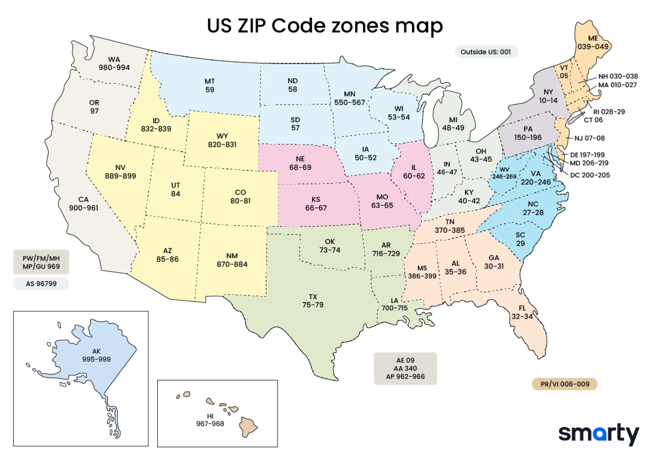
There are three main parts of the 5-digit ZIP Code—the national area, the region or city, and the delivery area. The United States Postal Service (USPS) has segmented the country into 10 ZIP Code areas. Starting in the northeast, they are number 0-9. The image in this section is a ZIP Code map of all 10 US postal zones or regions.
The first digit of the ZIP Code allocates as follows:
| ZIP Codes beginning with | States / territories |
|---|---|
| 0 | Connecticut, Massachusetts, Maine, New Hampshire, New Jersey, Puerto Rico, Rhode Island, Vermont, Virgin Islands, Army Post Office Europe, Fleet Post Office Europe |
| 1 | Delaware, New York, Pennsylvania |
| 2 | District of Columbia, Maryland, North Carolina, South Carolina, Virginia, West Virginia |
| 3 | Alabama, Florida, Georgia, Mississippi, Tennessee, Army Post Office Americas, Fleet Post Office Americas |
| 4 | Indiana, Kentucky, Michigan, Ohio |
| 5 | Iowa, Minnesota, Montana, North Dakota, South Dakota, Wisconsin |
| 6 | Illinois, Kansas, Missouri, Nebraska |
| 7 | Arkansas, Louisiana, Oklahoma, Texas |
| 8 | Arizona, Colorado, Idaho, New Mexico, Nevada, Utah, Wyoming |
| 9 | Alaska, American Samoa, California, Guam, Hawaii, Marshall Islands, Federated States of Micronesia, Northern Mariana Islands, Oregon, Palau, Washington, Army Post Office Pacific, Fleet Post Office Pacific |
How to read a ZIP Code
Let’s reference the basic structure of the original 5-digit postal code in the image below.
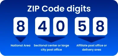
Here is a ZIP Code example. After the first number in a ZIP Code is assigned based on the National Area, the USPS assigns the next two numbers according to a city. The USPS often assigns the first ZIP Code to a region's main town or city. After that, the ZIP Codes will proceed alphabetically.
You might think of ZIP Codes as a mailing address for a particular post office. Some handle more than one ZIP Code, but a one-on-one game plan is a standard.
The first three digits of a ZIP Code together usually indicate the central mail processing facility, also referred to as a sec center or sectional center facility to which that ZIP Code belongs. This facility is the mail sorting and distribution center for a zone or area. Some sectional center facilities have multiple three-digit codes assigned to them. For example, the Northern Virginia sectional center facility in Merrifield is assigned ZIP Codes beginning with 220, 221, 222, and 223.
The fourth and fifth digits of the ZIP Code represent the area of the city or town. For example, if a letter is received with a ZIP Code of 47722, the USPS can know that it's in Indiana (4), it's in Vanderburgh county (77), and it's in the area of the University of Evansville (22).
ZIP Codes are lines; not shapes
It's essential to note that ZIP Codes aren't "boundaries." They're a collection of delivery routes. ZIP Codes aren't drawn according to state boundaries. In fact, since they’re designed only to increase mailing efficiency, ZIP Codes can, and do, cross county and state boundaries. For example:
- 42223 spans Christian County, Kentucky, and Montgomery County, Tennessee.
- 97635 includes portions of Lake County, Oregon, and Modoc County, California.
- 51023 and 51001 are in both Iowa and Nebraska.
Although most ZIP Codes can be roughly assigned to a geographic area, ZIP Codes do not represent geographic regions. ZIP Codes denote street address groups or delivery routes. Because of this, ZIP Code "areas" can overlap, be contained within another ZIP Code, or have no geographic area. For example, ZIP Codes that start with 095 are assigned to the Navy and therefore have no geographic location.
Similarly, areas without regular postal routes (rural route areas) or areas with no mail delivery (undeveloped areas,) are not assigned ZIP Codes. They are based on sparse mail delivery routes, so the boundary between ZIP Code areas there is indefinite.
To help you grasp this, consider the following example: If you're mailing a letter from Boston to Seattle, the mail carrier in Massachusetts doesn't care what the street address of the destination is. It's what you might call "outside his jurisdiction." He just needs to know which mail carrier to send it to so the appropriate mail carrier can do their job and get it to the correct address.
A postal worker can only cover so much ground on a given day. Since the USPS has a standard for delivering in the rain, sleet, or snow, it rules out the possibility of carrying out the delivery service in stages (some today, some tomorrow). That means any post office only serves what it can reach in a day. ZIP Codes reflect that.
You can see our instructions on how to find a county by ZIP Code. In cases where ZIP Codes cross county lines, Smarty displays the default county in the line labeled ‘County Name’ and includes an additional line labeled ‘Alternate Counties.’
Special, unique ZIP Codes
Some ZIP Codes are a bit different in function. Among them are "military" ZIP Codes, which include everything from military bases (domestic or otherwise) to battleships at sea. Then there are "unique" ZIP Codes. Businesses and organizations sometimes get a dedicated ZIP Code that they don't have to share with anyone due to the volume of mail they send and receive.
These frequently benefit from bulk mailing discounts since the organization usually has a mail department that (1) presorts mail before giving it to the USPS and (2) distributes mail internally, so the USPS doesn't have to. Like standard ZIP Codes, "military" and "unique" ZIP Codes circumscribe their delivery area.
Elevated ZIP Codes - The next generation
In 1983, the USPS moved to the next generation of ZIP Codes and changed its system to include the new ZIP+4. These ZIP Codes use the basic five-digit code plus four additional digits for a 9-digit ZIP Code. The fuller version of a ZIP Code identifies a small mail delivery segment such as a street, a city block, a group of apartments, or even an individual street address that receives a high volume of mail. These types of extended ZIP Codes aren’t required and are usually calculated automatically when the mail is sorted and processed. They look like this:
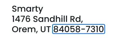
As a rule, each Post Office Box has its own +4 Codes. The additional digits on these extended ZIP Codes are often the last four digits of the box number, zero plus the last three digits of the box number, or, if the box number is less than 4 digits, zeros followed by the box number. Because of this variance, the extended ZIP Code must be looked up individually for each Post Office Box.
Not all USPS deliverable addresses have those extra 4 digits assigned to their ZIP Codes. For those postal addresses, geocoding lookups or address validation that require a ZIP+4 may not succeed. Even though the USPS might not provide accurate geocodes for those addresses, Smarty can still provide roof-top level geocodes for most addresses in the US.
You can explore more options by testing the Smarty US ZIP Code API or by reading our ZIP Code API documentation.
Conclusion
TLDR: A “ Zone Improvement Plan” or ZIP Code uses 5 numbers to point to a specific post office or area for mail delivery. Essentially, ZIP Codes refer to a particular area serviced by the USPS.