How to batch geocode for the most precise results
To batch geocode, or perform batch geocoding, is the process of uploading a spreadsheet or list of addresses to a software provider and receiving back the corresponding latitude and longitude coordinates for the entire list of addresses at once.
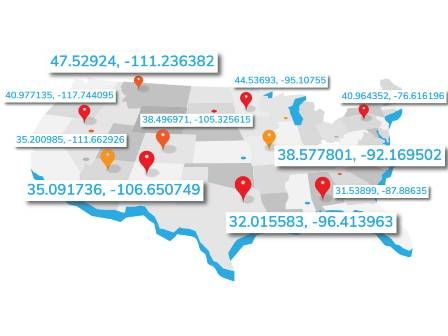
These latitude and longitude coordinates are called geocodes. Geocoding is useful for plotting addresses on a map to determine voting districts, finding distances from one point to another, insurance risk assessment and hundreds of other use cases. Many businesses use geocoding to perform specific market/region data analysis before moving forward with new campaigns or initiatives.
There are different types of geocoding, with varying degrees of accuracy. Your business needs will determine which type of geocoding you want to use and if you need a geocode services provider that offers batch geocoding.
Smarty offers many ways to batch geocode. Here are some methods that may fit your needs.
In this article we’ll cover,
- What is batch geocoding?
- Video: How to batch geocode in 5 easy steps
- What is a batch geocoding API
- Sub-parcel geocodes
- Geocoding accuracy levels
What is batch geocoding?
Now that you have a better idea of what level of geocoding accuracy your business needs, let’s talk about how you can be accurate and efficient by batch geocoding. (That sound you hear is your accounting department swooning.)
Batch geocoding is when you upload a spreadsheet, list or CSV file of addresses to a software provider like Smarty and receive the corresponding latitude and longitude coordinates for the entire list of addresses at once. Geocoding many addresses at once is also known as bulk geocoding.
Just like buying in bulk is awesome because you can hoard more toilet paper than everyone else, geocoding in bulk is awesome because you can save time and get all the geocodes you need at once.
How much time can you save? Well that depends on how fast your geocoding provider is.
Many batch geocoding services can do 27, 50 or even 200 geocodes per second. You might be thinking that sounds pretty good.
But in reality, if you have ten million addresses to process, that batch geocode request is going to take 2.3 days at a rate of 50 geocodes per second.
Smarty can process geocodes for 25,000 addresses per second in the cloud. Those ten million geocodes you wanted? Ready in 6.6 minutes.
If you're looking to make batch geocoding even easier, Smarty now offers a plugin for Excel that allows you to geocode directly from your spreadsheets. No need to export your address data into separate files—simply select your list of addresses within Excel, click the Smarty plugin, and watch as the latitude and longitude coordinates populate instantly. It's the same lightning-fast geocoding you expect from Smarty, now streamlined within the tools you use every day.
Video: How to batch geocode addresses in 5 easy steps
How do we batch geocode addresses so fast? The secret’s in the sauce—er, scale.
Our system scales based on load. Rather than overwhelming the system and forcing customers to queue or allowing our system to slow to a crawl under high loads, Smarty spins up new servers almost instantly to accommodate higher usage. The end result is a reliable and predictable system with almost supersonic speeds.
But that’s all behind the scenes. All YOU need to do in order to batch geocode addresses is to follow these simple steps.
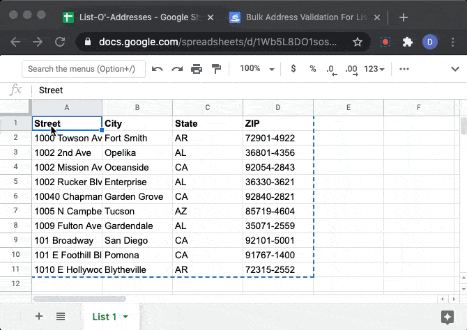
- Visit our bulk address validation page
- Paste your formatted list. (Here's an example file.)
- Enter your license key (optional)
- Click “Process my List”
- Enjoy your geocodes. Latitude will be in columns "Q" and longitude in column "R".
The trial can geocode a batch of 10 addresses with block level accuracy. Want rooftop accurate geocodes? Sign up for a 42-day free trial, enter your licence key and you can batch 1,000 US rooftop geocodes free. Need more than 1,000? Sign up for a paid plan and batch geocode up to 50,000 per request.
Still not enough? Our batch geocoding API will automatically return the validated, standardized version of the address as well as the latitude and longitude coordinates (geocodes). Our geocoder features plans that can geocode 25,000 per second in the cloud. We also offer a reverse geocoding API, where you enter latitude/longitude coordinates and our tool converts them into corresponding street addresses with the same speed capabilities.
What is a geocoding API
Geocoding APIs are Application Programming Interfaces that programmatically convert street addresses into the corresponding latitude and longitude coordinates. A batch geocoding API converts large data sets at once.
A geocoding API also allows users to create an application that links up with the geocoding service’s dataset in order to automate internal and web-based batch geocode requests. A geocode API allows you to pick and choose what data-points you want to receive and customize how they are displayed. This means that geocoding APIs can also be useful for customer facing applications to allow your users to get geocodes directly. Finding a provider that offers a geocoding API will enable you to create automated workflows with limited upkeep.
What are sub-parcel geocodes?
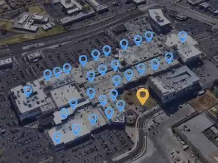
A single rooftop or parcel doesn’t always mean a single address. Apartment buildings, strip malls, business parks and manufactured home parks contain many sub-addresses.
Smarty frequently can correctly identify and place a pin in the correct location where many other providers cannot, such as an apartment unit, suites within an office park, individual structures in manufactured home parks and individual building within a larger complex.
For example, let’s look at the geocode of 511 Walnut St, Cincinnati, OH 45202, the address of a popular ice cream shop in Ohio called Graeter's Ice Cream. 511 Walnut Street is actually a large office building, and the ice cream shop is a relatively small corner tenant.
A sub-parcel geocode would be able to pinpoint the exact location of frozen deliciousness within the larger office building. What can we say except, "You’re welcome".
Geocoding accuracy levels
1. ZIP+4 (block) level geocodes
ZIP+4 Codes (or ZIP Plus 4 Codes) are the final 4 digits of a full nine-digit ZIP Code. The 9-digit ZIP Code consists of two sections. The first five digits indicate the destination post office or delivery area. The last 4 digits represent specific delivery routes within delivery areas.
A ZIP+4 Code route generally contains 10-20 addresses. A ZIP+4 level geocode is simply the approximate center of that route. This makes these geocodes accurate to about the block level of the desired address. This is great if you only need the approximate location of an address without needing to know the exact rooftop or parcel. ZIP+4 level geocoding is generally more affordable, as well.
2. Interpolated geocodes
Interpolated geocodes make a guess of where an address resides based on verified points, often intersections for gridded streets.
For example, let’s look at how to find the interpolated geocode of 511 Walnut Street. The ice cream shop in Ohio.
A geocoding service that offers interpolation geocoding would start by matching the street name, direction and street type against a block range in the street center line database. It would be disambiguated from other streets of the same name by using the city name or postal code, if available. There are 237 Walnut Streets in Ohio alone, so choosing the right one is essential if you’re craving frozen treats.
Once the geocoder has determined the street, it will use the street number to find the closest block. For 511 Walnut St, it likely is aware of street intersections at each end of the 500-600 block of Walnut Street.
Next comes the actual math step—interpolation. There are 100 potential addresses on that block, but realistically only a dozen or less properties on a block.
When we use math to determine where 511 Walnut Street is between the beginning and end of the block, the math puts the geocodes at regular intervals and set patterns, but if you’ve ever gotten lost in an unfamiliar city, you know that buildings aren’t always logically arranged. So the precise physical geocode of an address may be different from the interpolated geocode for that same address.
Another guess the geocoding service has to make is how far off from the street to make the building. Typically, a geocoding service will have default parameters for this, like 50 feet back from the street.
Finally, the geocoder has to choose a side of the street to place the address. In many cities in the United States, odd and even numbers are consistently on opposite sides of the street—but not always! And in the case of our ice cream shop example, while the address is 511 Walnut Street, the entrance to the shop is actually on Fifth Street. Situations like that require knowledge of the geographic area to produce an accurate result.
All this to say, when we use interpolation to create geocodes, we're creating geocodes that are "street-segment" accurate, but not "rooftop accurate."
3. Parcel centroid geocodes
Parcel geocoding is much simpler than interpolated geocoding, but it requires much more granular data and can be more expensive as a result.
Parcel centroid geocodes are calculated by taking the known boundaries of a property. Then, you approximate the geocode in the center of the parcel.
An important consideration with parcel centroid geocodes is that houses are often not built in the geographic center of the property. This is especially true in the cases of large or irregular parcels, such as a farm.
If you ask any hardcore location data nerd, they’ll tell you that the bigger a parcel, the less useful the parcel centroid geocode. (Really, just ask us!) Often, you need to pinpoint the roof of the home, and knowing the center of the parcel is not precise enough. Parcel centroid geocodes may fall hundreds of feet from the home or structure.
4. Rooftop geocodes
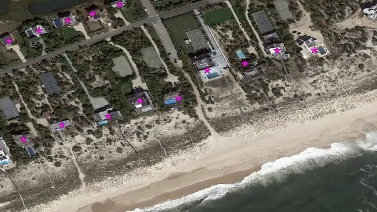
Rooftop geocoding is the gold standard in the location intelligence industry. Knowing exactly where the primary structure is on a parcel can help businesses with sales and marketing strategies, as well as provide valuable data to governments about rescue and evacuation routes. For many use cases, the difference in accuracy between parcel centroid and rooftop geocodes can be the difference between success and failure. That’s why rooftop geocoding exists—and why it can be more expensive.
Rooftop geocodes start with the parcel centroid geocode, which is then refined using additional data from multiple sources, such as census and navigational data, and calculations in order to match the geocode with the actual rooftop of the primary structure on the parcel.
Smarty offers hyper-accurate US Rooftop Geocoding. Our geocodes consistently hit the roof of the primary structure on the parcel. “Rooftop” geocodes that hit the backyard or the chicken coop or the freestanding garage-turned-man-cave don’t count. While many geocoding providers will say they have "rooftop” geocoding, they’re far from doing that consistently.
Where rooftop geocodes are not possible, we provide ZIP+4 geocodes. Because our service is so accurate, we can often get more granular with our rooftop geocodes and provide sub-parcel geocodes.
Try geocoding with smarty
Using our Bulk Address Validation Tool, you can get up to 10 geocodes at a time free. Simply paste in a spreadsheet of addresses, and our tool will automatically return the validated, standardized version of the address as well as the latitude and longitude coordinates.
Need more than 10 geocodes at a time? Sign up for a 42-day free trial and get 1,000 geocodes free!
Was this helpful?
