FFIEC geocoding - What it is & how to use it

FFIEC geocode refers to the FRB Census Geocoder, a system that helps US financial institutions meet their legal reporting requirements, specifically reporting on mortgage, farm, and business loans.
The Federal Financial Institutions Examination Council (FFIEC) employs geocoding to gather information for compliance with the Home Mortgage Disclosure Act (HMDA) and the Community Reinvestment Act (CRA).
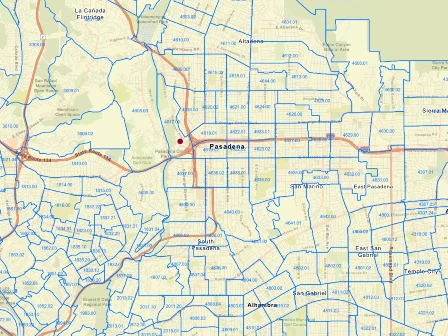
The federally funded tool helps organizations accurately identify the geographic location of a property address for compliance, reporting, and decision-making.
While the free FFIEC Geocode website can be an excellent resource, it also has some limitations that make it challenging for many businesses to use. These shortcomings cause many organizations to turn to other marketplace solutions that facilitate programmatic integration into existing systems via Application Programming Interface (API) to streamline processes, improve data quality, and minimize user error.
For example, Smarty's US Census Block and Tract Data provides the same information as the FFIEC Geocoder, including all the relevant names and codes for MSA/MD, state, county, & tract. Take a peek at our US Census Block and Tract Data page, chat with an expert, or continue learning about the FFIEC geocoder below.
| US Census Block and Tract Data | US Address Validation |
|---|---|
Here's what we'll be exploring in this article:
- FFIEC basics
- How FFIEC geocoding works
- The importance of FFIEC geocodes in business
- Overcoming challenges with FFIEC geocodes
- FFIEC geocoding alternatives
- TL;DR - Too long; didn't read
FFIEC basics
Who exactly is the FFIEC, and what do they do? FFIEC stands for the Federal Financial Institutions Examination Council. Established on March 10, 1979, the FFIEC assists in fostering uniform standards for financial institutions. It supervises the real estate appraisal process in the United States.
The FFIEC is an interagency body of the US government, made up of 6 member agency levels:
- Board of Governors of the Federal Reserve System (FRB)
- Federal Deposit Insurance Corporation (FDIC)
- National Credit Union Administration (NCUA)
- Office of the Comptroller of the Currency (OCC)
- Consumer Financial Protection Bureau (CFPB)
- State Liaison Committee (SLC)
These levels are not hierarchical but work collaboratively with different specialties to achieve the same goal. They maintain financial safety and soundness in the system. The FFIEC will directly monitor all federally supervised financial institutions and their holding companies/subsidiaries.
How FFIEC geocoding works
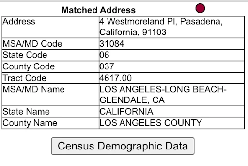
The FFIEC Census Geocoding System is available via a one-at-a-time, web-based address entry tool. The system provides basic data required for each reported loan, including:

- Metropolitan Statistical Area/Metropolitan Division (MSA/MD) name & 5-digit MSA/MD Code
- State name and 2-digit state FIPS Code
- County name and 3-digit County FIPS Code
- Census tract code
The tool is easy to use and allows you to find the data for US addresses quickly, but it also has some limitations. Here is a partial list you should be aware of:
- The tool allows users to enter an address but misses many typos – including non-existent building numbers, apartment & suite numbers, incorrect or missing predirections and postdirectionals (775 W that should've been 775 E), etc.
- It doesn't offer any bulk upload options or access via an Application Programming Interface (API), so you can't incorporate it into existing systems or automated processes.
- Users must look up addresses individually; there's no option to export or save data.
- After looking up an address, users must copy and paste data, which introduces opportunities for user error, wasted time, and inconsistent data collection.
- The tool struggles with non-standardized, incomplete, and messy address data, leading to incorrect reporting and faulty information.
- As the name suggests, you'd think it would provide geocode data, but it doesn't. You'll need to find a different geocoding tool for actual geocodes.
Even with these shortcomings, the FFIEC geocoding tool provides valuable insights, useful data, and the ability to comply with federal and state laws; if you have the time for manual data entry, that is.
The importance of FFIEC geocodes in business
Now that we know who the FFIEC members are, their purpose, and some of the limitations of their geocoding tool, let's explore how they utilize the beautiful world of geocoding to benefit the United States.
Insurance
Insurance agencies have to gather risk data, the likelihood of encountering damage to a property, and the level of severity at which it could occur. Before a client purchases insurance, the agency must gather that risk data to set the policy pricing and limitations accordingly. While agents use many tools and data sources, the FFIEC geocoding system is helpful.
Real estate

The FFIEC geocoding map is especially useful in the realm of real estate. The census tract number can give critical information to allow mortgaging agents to work within the context of the Home Mortgage Disclosure Act (HMDA) and the Community Reinvestment Act (CRA).
In a nutshell, the HMDA is a law that forces lenders to share information about the home loans they process, preventing bias and unfair lending practices while promoting equal access to loans. The law simultaneously gives a deeper insight into potential issues or trends in the future of mortgages within that community.
The FFIEC geocode system shows the precise location of the home requiring a mortgage, which gives the broker and lender more information than just the street address or ZIP Code. They can gain an accurate mortgage lending analysis.
A concise explanation of the CRA is that it's a law that tells banks they need to unbiasedly support the communities where they operate, especially lower income brackets. It helps ensure that access to money is granted fairly to all, regardless of economic status.
The insurance and real estate sectors must uphold a legal requirement to report financial information to the FFIEC to be considered financially compliant and to continue operations.
Overcoming challenges with FFIEC geocodes
Wait, there are challenges to using FFIEC geocodes? Yes, but luckily, most of them are avoidable.
-
User error
Problem: The first problem people encounter is what we like to call user error. While the FFIEC gov geocoding system is incredibly smart, it's also very fussy. A misplaced comma, misspelled street name, or misidentification of a street type (typing avenue instead of drive, for instance) will result in a failed look-up or information for the wrong address.
Solution: A quick double-check of the information you entered before you request the geocode lookup will help. Utilizing address verification or standardization software can assist in this process as well.
-
No PO Box or rural route lookups

Problem: Unfortunately, the FFIEC is unable to provide data for PO Boxes and Rural Routes.
Solution: Smarty can help fill in those blanks since we return data on Rural Routes and PO Boxes.
-
Incorrect activity year selection
Problem: The FFIEC is very particular on how you use it. For example, on their site, they explain:
The information provided by this system is for the reporting of 2015, 2016, and 2017 CRA and HMDA data. Geocoding information for 2015 and 2016 is based on the 2010 Census. Geocoding information for 2017 is based on the 2015 Census.
You may receive an inaccurate representation if you don't enter the correct year for the geocoding census data you seek.
Solution: Well, you get the gist. Make 100% sure that you're searching for the correct year.
FFIEC geocoding alternatives
There are a few data points that the government's FFIEC geocoding system provides to users, but the quality of their output depends on the quality of the address entered into the tool.
Without correcting typos and identifying missing address components, the tool can provide incorrect data, leading to companies unwittingly falling outside of compliance with Federal mandates.
Solution 1: Incorporate Smarty's US Address Validation into your process to help you clean, standardize, and deduplicate your address before you enter it into the FFIEC geocoder. With it, you'll drastically improve the quality of the data output.
Solution 2: Bypass the manual data entry processes of the FFIEC geocoding tool entirely by using Smarty's US Census Block and Tract data through our US Address Enrichment API. It provides all of the data points provided by the FFIEC tool, including:
- Metropolitan statistical Area/Metropolitan Division (MSA/MD) name & 5-digit MSA/MD Code
- State name and 2-digit state FIPS Code
- County name and 3-digit County FIPS Code
- Census tract code
All of this data is available through Smarty's APIs, which means the entire standardization, validation, and enriching of your address data with MSA, census block, and tract information can be programmatically incorporated into your existing organizational systems so that you'll never need to look up the data manually again.
Plus, You'll also get tons of additional metadata about the address, including rooftop accurate geocodes (yes, unlike the FFIEC geocoder, our geocoding tools supply address geocodes), congressional districts, timezone, residential delivery indicator to bring up your address game to an 11.
TL;DR - Too long; didn't read

The FFIEC is crucial for maintaining financial safety in the U.S. FFIEC Geocodes have diverse applications, benefiting sectors such as GIS, insurance, and real estate. The geocode tools aid in precise location data, but users must be cautious of potential errors and limitations.
Overall, FFIEC Geocodes are valuable assets, but they can be significantly outdated and have limited data. Utilizing other address tools to assist in the process of getting accurate geocoding data for HMDA and CRA compliance will be your safest bet to ensure success.
If manual data entry isn't your thing (it's not ours either) and you'd like to systematize the entire process, try our US Address Verification tool, and take our US Census Block and Tract Data for a test drive too.