


What is data enrichment for P&C insurance?
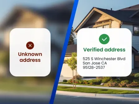
P&C insurance data enrichment uses APIs to automatically append third-party data to existing records, enabling P&C insurers to add geocodes, property characteristics, firmographic information, and parcel data to an insured property’s address to better understand the property and its risk exposures.
P&C insurers often have chaotic, fragmented, or incomplete property records. Insurance data enrichment bridges those gaps, enabling P&C insurers to build comprehensive risk profiles that improve:
- Risk assessment and catastrophe modeling: Location, structural, and financial data attributes, like year built and construction type, help underwriters develop precise risk scores and predict future risk and potential catastrophic loss.
- Eligibility decisions and policy pricing: With accurate property risk assessments, P&C insurers can better determine eligibility, coverage levels, and competitive premium rates.
- Claims processing: Data enrichment helps claims teams understand what was on a property and its condition at the time of loss, so when a claim comes in with photos and receipts, they can accurately assess depreciation.
- Portfolio diversification: Insurers can also use rooftop-level geocodes to pinpoint portfolio properties, then analyze their concentration, geography, and exposure aggregations.
But before P&C insurers can utilize insurance data enrichment to fill property data gaps, they need to ensure their existing data is complete, correct, and up to date. To do that, P&C insurers can implement:
- Address verification: Verify addresses against an authoritative database to ensure addresses are real and up-to-date before enrichment
- Rooftop geocoding: Turn verified addresses into precise latitude and longitude coordinates
Want to see how it works? Talk to an address data expert, or read on to learn how address verification, rooftop geocoding, and insurance data enrichment improve underwriting, claims, and portfolio management workflows.
Table of contents
- What is data enrichment for insurance?
- Why clean address data is the foundation of insurance enrichment
- What data can be added to insurance records?
- How teams use insurance data enrichment
- How to build an insurance data enrichment workflow
- How to choose a P&C insurance data enrichment solution
- Conclusion
- FAQ
What is data enrichment for insurance?
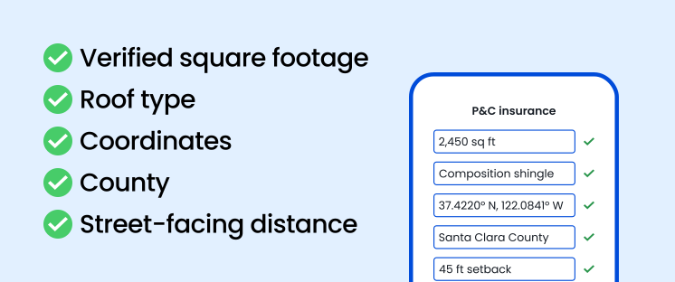
Insurance data enrichment is the process of appending verified external data to existing insurance records through an API. It helps underwriters, claims teams, and portfolio managers fill gaps in property records and build comprehensive risk profiles.
For P&C insurers, insurance data integrations typically start with a property address and append different types of data, including:
- Address metadata: Address structure, deliverability, location, geography, persistent, unique identifier, etc.
- Rooftop-level geocodes: Precise latitude and longitude coordinates for the primary structure at an address
- Property characteristics: Location, structure, and financial attributes from hundreds of public data records
- Firmographic data: Company size, name, phone, operating hours, NAICS code, SIC code, etc.
- Parcel data: Parcel boundaries, structure count, land used, zoning, and total market value
Why clean address data is the foundation of insurance enrichment
For P&C insurers, insurance data enrichment ultimately ties back to a property’s location, meaning insurance enrichment is only as accurate as the addresses it relies on. Missing secondary information, an outdated street name, inconsistent address formatting, or any other address error could cause a mismatch between an address and enrichment data.
Smarty’s US Address Verification and US Rooftop Geocoding tools are designed to prevent just that. Here’s how you can use these address and location data tools for P&C insurance companies to clean your address data, creating a stronger foundation for insurance enrichment.
Address verification
US Address Verification matches addresses against an authoritative database of over 210 million USPS, non-USPS, new-build, and provisional addresses. If any address components are changed to create a match, US Address Verification can highlight what was updated, why the changes were made, and whether each address component is valid. That address component analysis allows insurers to flag incomplete or questionable addresses for review before insurance enrichment.
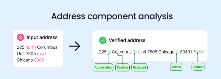
US Address Verification also standardizes addresses to meet USPS formatting guidelines. This provides underwriting, claims, portfolio management, and other insurance teams with a consistent address for a single property across systems, so address enrichment efforts on any team return the same, reliable results.
Persistent, unique identifiers
After standardization, US Address Verification attaches up to 55 metadata points—including county name, county FIPS, vacancy status, and SmartyKey®, a persistent, unique identifier—to each address.
Because SmartyKey remains consistent even when an address changes, insurers can use it to track and deduplicate property records. That helps insurers link records across teams and simplify insurance data migration before enriching insurance data, even when city names, street names, or ZIP Codes change.
Rooftop geocoding
US Address Verification returns ZIP9 geocodes—which estimate the center of an address’s delivery route segment—as address metadata. Like ZIP9 geocodes, street-level and parcel-centroid geocodes estimate a property’s location, making them useful for workflows that only need an address’s approximate location.
Underwriters need a more robust level of geocoding accuracy to pinpoint property locations and measure distances to potential hazards or risk zones. That’s why US Rooftop Geocoding is the perfect complement to US Address Verification.
US Rooftop Geocoding gives you the latitude and longitude coordinates for the primary structure on a parcel, even down to the secondary number when available.
For Mountain West Farm Bureau, US Rooftop Geocoding provided underwriters and actuaries with precise locations for insured properties in rural areas, where large, irregularly shaped parcels are common, and risk conditions can vary over short distances.
“The precision of the rooftop is important to our rating algorithm so that we can take into account exactly where that location is,” Tim Hays, the Vice President and CIO at Mountain West Farm Bureau Mutual Insurance, explained.
The precision of the rooftop is important to our rating algorithm so that we can take into account exactly where that location is.

Using rooftop-level geocodes alongside address verification, insurers can build a foundation of clean address data for insurance data enrichment, enabling them to have confidence in their results and to create accurate risk profiles.
Looking for it all in one place? Check out the comparison table below.
| Process | Primary purpose | Example output |
|---|---|---|
| Address verification | Confirm and standardize addresses against a comprehensive address database | Improves data governance and match rates before enrichment |
| Persistent, unique identifiers | Create a single, constant identifier for a location | Helps insurers identify, link, merge, and eliminate duplicate records across systems |
| Rooftop-level geocoding | Find the latitude and longitude coordinates for the primary structure at an address | Helps insurers identify relationships between properties and potential risks |
| Data enrichment | Add data from third-party providers to verified, geocoded addresses | Provides relevant context about a property and its surrounding hazards |
What data can be added to insurance records?

Data enrichment for insurance teams can add a variety of data to verified, geocoded addresses. The table below outlines the most common categories.
| Data category | Example attributes | Insurance use |
|---|---|---|
| Address metadata | Delivery readiness, persistent unique identifiers, vacancy indicator | Record quality, completeness, and identification |
| Location attributes | Latitude, longitude, precision level, county, elevation | Property, hazard, and risk mapping and analysis |
| Structure attributes | Square footage, land ownership, roof material, construction type | Underwriting and portfolio diversification |
| Parcel data | Parcel boundaries, structure count, use description, zoning, acreage | Parcel-level analysis and risk modeling |
| Customer data | NAICS code, SIC code, operating hours, business name, phone number for business customers | Risk classification and claims processing |
| Hazard and climate | Flood, wildfire, wind, hail, historical storms | Predicting future risk and losses from catastrophes |
| Claims and events | Event footprint, loss location, affected area | Claims response and triage |
Property data enrichment
Address metadata, location attributes, structure attributes, and parcel data all fall under property data enrichment. P&C insurers can enrich property addresses with these data points to complete fragmented or incomplete property records, which improves risk assessment and catastrophe modeling.
Customer data enrichment
Many P&C insurance companies insure businesses as well as individuals. In those cases, customer data enrichment adds business data to customer addresses to streamline risk classification and claims routing.
Risk and hazard enrichment

Insurers can also add hazard and climate data—and the claims and events that follow climate-related hazards—to property locations. However, because climate-related hazards are constantly changing (for example, Tornado Alley is shifting eastward), it’s important to ensure your third-party data provider maintains a regular cadence of updates.
How teams use insurance data enrichment
Data enrichment for insurance teams can improve underwriting, claims, and portfolio management workflows by adding property and customer data to fragmented or incomplete property records.
Underwriting, claims, and portfolio management teams can build comprehensive risk profiles that improve insurance data and analytics workflows by enriching fragmented or incomplete property records with property and customer data.
Smarty’s US Property Data, US Parcel Boundary Data, and US Business Data tools are built with that purpose in mind. Here’s how your team can implement these solutions and benefit from insurance data integration.
Underwriting and pricing
Underwriters can pinpoint property locations using verified, geocoded addresses.
From there, US Property Data and US Parcel Boundary Data can enrich those locations with up to 350 property characteristics and 110 parcel attributes, including:
- Elevation
- Year built
- Construction type
- Parcel acreage
- Total market value
That data can enable underwriting prefill. When applications are automatically prefilled with accurate property and parcel data, applicants save time on manual entry, and underwriters receive more reliable information for risk assessment.
Combine property and parcel data with hazard and climate data, including weather exposure, catastrophe exposure, and historical environmental information, and underwriters can build more complete property risk profiles and better price policies.
Prefilled property and parcel data also provides underwriters with the information they need to create risk models that predict future risk and estimate potential catastrophic loss. That helps underwriters bind new policies with confidence.
Claims handling and catastrophe response
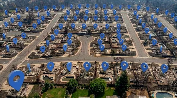
While not a complete claims-management platform, Smarty’s address verification, geocoding, and enrichment tools can serve as an insurance claims data enrichment tool.
When a catastrophe strikes, insurers use verified, geocoded addresses to quickly identify claims within an affected area, then route nearby adjusters to them to speed up catastrophe responses. With US Property Data and US Parcel Data added to that location, claims teams can compare the location context against policy, property, and event information and then prioritize catastrophe responses.
Outside of catastrophe response, claims teams can rely on insurance data integration solutions to classify risk and route claims for commercial customers.
Using Smarty’s US Business Data, insurers can enrich commercial customers’ addresses with NAICS codes to streamline risk classification.
For example, a customer address enriched with the NAICS code 331511 can be quickly identified as an iron foundry and estimated to have a higher risk than an address associated with the NAICS code 541110, which refers to a law firm.
Portfolio and accumulation management

P&C insurers can use US Rooftop Geocoding to identify insured properties at precise geographic coordinates, then enrich those locations with hazard and climate data to better understand where policies in their portfolio may be clustered within wildfire, flood, or other high-risk zones.
With US Parcel Boundary Data, which provides parcel boundaries and geographic data, P&C insurers can run territory analyses alongside concentration analyses. That way, they can better assess whether their exposure in a specific area could lead to an unsustainable loss ratio and make more informed decisions about portfolio diversification.
How to build an insurance data enrichment workflow
For P&C insurers, data enrichment starts with fragmented property records and ends with quality control. As you’re developing your own insurance data integrations, here’s a template you can work from:
- Identify gaps in property records
- Implement an address data solution
- Verify and standardize property addresses
- Assign a persistent location identifier and other metadata points to each verified address
- Geocode the verified address to the secondary level
- Attach enrichment data to the verified, geocoded address
- Record the enriched data sources, confidence, precision, and retrieval date
- Monitor match quality and refresh enriched attributes
How to choose a P&C insurance data enrichment solution
Conclusion
Effective data enrichment for insurance teams starts with identifying the correct insured property. Verified, standardized addresses and rooftop geocodes provide a stronger foundation for adding missing context to property records.
Once addresses are verified and geocoded, they can be reliably enriched with property, parcel, and business data to help P&C insurers improve underwriting, claims, and portfolio management workflows.
To see how Smarty supports P&C insurance data enrichment, talk to an expert! Or start a 42-day free trial of address verification, geocoding, and enrichment to see the difference for yourself.
FAQ
What is data enrichment?
Insurance data enrichment adds external data to raw data from internal sources through an API. P&C insurers typically use enrichment to append geographic, property, parcel, and business data to property addresses.
What is data enrichment used for in insurance?
Data enrichment powers underwriting, claims, customer records, portfolio analysis, catastrophe modeling, machine learning, artificial intelligence, and other insurance data pipelines, giving teams a comprehensive understanding of a property.
What is data enrichment changing for claims processing?
Using the business data provided by enrichment, claims teams can automatically classify risk and route claims to the right destination. Claims teams can also use rooftop-level geocodes as an insurance claims data enrichment tool to improve event matching and adjusters deployment.
What is the difference between address verification and geocoding?
Address verification checks and standardizes addresses against an authoritative database, while geocoding converts verified addresses into geographic coordinates. Together, verification and geocoding improve address data quality before data enrichment.
Why is rooftop geocoding important for insurers?
High-precision coordinates help teams identify the primary structure on a parcel, rather than the property’s street, ZIP Code, or parcel center, enabling precise risk assessments and policy pricing.
What data can insurers use to enrich customer and property records?
Insurers can enrich customer and property records with:
- Address metadata
- Location attributes
- Structure attributes
- Parcel data
- Customer data
- Hazard and climate data
- Claims and events
How should insurance teams evaluate a data enrichment provider?
When looking for a data enrichment provider, insurance teams evaluate their:
- Address data quality and coverage
- Geocoding precision level
- Enrichment data quality, coverage, and update cadence
- Free trial offering
- Ease of integration
- Customer support
- Scalability
What is data enrichment vs data cleansing?
Data enrichment adds additional data from external sources to existing records. Data cleansing removes corrupt or inaccurate data from those records beforehand.
What is data enrichment vs data enhancement?
Data enhancement combines both data cleansing and enrichment. It cleans and fixes existing records, then enriches them with additional data.
Was this helpful?