
Location intelligence software for P&C insurance
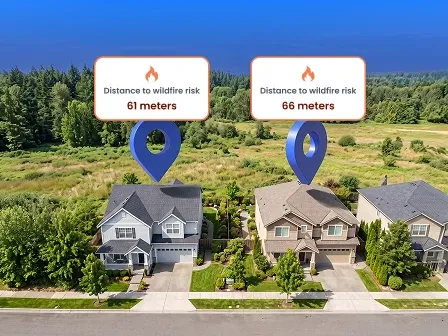


Location intelligence software uses location data such as addresses, geocodes, and property attributes to help P&C insurance underwriters and risk management teams analyze risk, detect fraud, and manage portfolios. Common types of location intelligence software include risk management, catastrophe modeling, and claims triage platforms.
However, for many P&C insurers, these platforms rely on disconnected, inconsistent, or incomplete location data. That chaos can cause a location intelligence tool to miss risk exposures, leading to costly mistakes downstream.
But with a database of accurate addresses, geocodes, and property data, location intelligence tools can better visualize data, run spatial analyses, build risk models, and tie business data to specific locations.
To improve the quality of their location data before it’s used by location intelligence software, P&C insurers can implement:
- Address verification: Match and standardize addresses against an authoritative database.
- Rooftop-level geocoding: Turn addresses into precise latitude and longitude coordinates.
- Address enrichment: Add location and structure attributes to verified addresses.
Ready to take these tools out for a spin? Talk to an address data expert, or keep reading to learn how location intelligence for insurance helps underwriting, property risk analysis, claims, fraud detection, and portfolio decisions.
In this article, we’ll discuss location intelligence software and show location intelligence examples as we cover:
- What is location intelligence software?
- Why location intelligence is important to P&C insurance
- How location intelligence data works for P&C insurance
- How Smarty powers location intelligence solutions for P&C insurance
- Location intelligence success stories for P&C carriers
- Why leading P&C carriers choose Smarty for location intelligence data quality
- FAQ
What is location intelligence software?
Unlike geographic information systems (GIS), which focus on collecting and mapping geographic data, location intelligence software for P&C insurance aggregates a variety of data types to create a comprehensive view of a property’s location and how that location affects exposure and risk. Those data types include:
- Address and location data: Verified addresses and rooftop-level geocodes
- Property and parcel data: Location, structure, and parcel attributes like elevation, county, square footage, roof material, parcel zoning, and parcel acreage
- Hazard and catastrophe data: Historical floods, wildfires, storms, and other climate-related hazards
- Administrative boundaries: National, regional, and local borders
- Policy and claims data: Event footprint, loss location, affected area, etc.
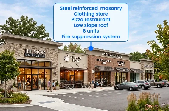
Still curious about the difference between location data, location intelligence, and insurance analytics? Check out the table below:
| Location data | Location intelligence | Insurance analytics | |
| Definition | Identifies a specific location on Earth | Derives insights from location and business data | Uses location intelligence for insurance companies to assess risk, manage claims, and detect fraud |
| Example | The rooftop-level geocode for a property | The distance between that property and a wildfire zone | The forecast of future outcomes, like risk likelihood, for that property |
Why location intelligence is important to P&C insurance
P&C underwriters and risk management teams base risk, fraud, and portfolio decisions on location data intelligence. Here are three examples of how those decisions make an impact.
1. Risk assessment
Underwriters need to know where a structure is located before they can accurately assess its exposure to floods, wildfires, tornadoes, crime, or other hazards. Risk management software can provide that property risk intelligence, but only when it relies on accurate location data.
With rooftop-level geocoding pinpointing the property’s location, insurers can identify a structure’s location on a parcel. Then, with up-to-date hazard and catastrophe data, underwriters can determine whether that property falls within a hazard zone and if it matches their appetite.
That level of accuracy improves location-based risk analysis and helps underwriters avoid misclassifying risk and mispricing policies.
2. Catastrophe response and fraud review
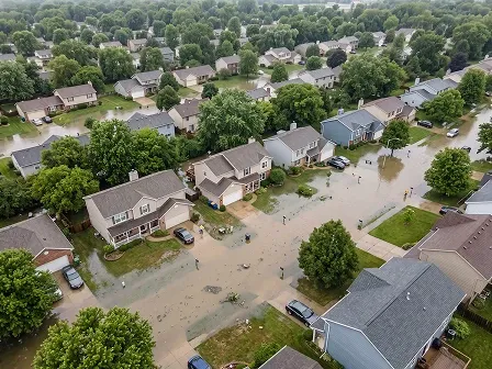
Accurate location data intelligence helps claims teams respond quickly to catastrophes and fraud.
Following a catastrophe, claims triage software can reduce response times by identifying insured properties within an affected area using rooftop-level geocodes, estimating which properties experienced the most damage using a catastrophe event footprint, then routing adjusters accordingly.
Location data intelligence can improve response times to fraudulent claims. Verified, geocoded addresses can confirm that a property is actually located where a claimant says it is. When conflicting data arises, the claim can be flagged for further investigation.
3. Portfolio diversification
Location data intelligence can also help P&C insurers analyze portfolio risk by layering hazard and catastrophe data with rooftop-level geocodes. Together, that data makes it easy to spot geographic and risk-type concentrations. When insurers take on too much risk in one area or type of hazard, they can use that visibility to diversify their portfolios.
How location intelligence data works for P&C insurance
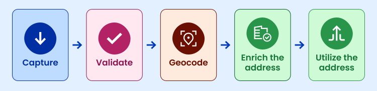
Location intelligence tools only produce reliable results when they rely on accurate, complete location data. That makes it important for P&C insurers to ensure their location data is accurate before using it in a location intelligence tool.
To do that, P&C insurers integrate address verification, geocoding, and enrichment into their workflows, which may include:
- Capture the property address with address autocomplete
- Validate and standardize the address
- Geocode the address to rooftop-level coordinates
- Enrich the address with property, parcel, hazard, or administrative data
- Utilize the address in location intelligence tools for quoting, underwriting, claims, or portfolio systems
Why precision matters
Because insurers rely on location intelligence tools to inform underwriting, claims, fraud detection, and portfolio decisions, precision matters at every step, starting with data entry.
To keep property addresses valid from the start, you can implement address autocomplete, which helps applicants enter verified addresses in just a few keystrokes. That saves time for both the applicant and the insurer, all while giving insurers more confidence in their location data.
Afterward, address verification corrects any remaining address errors, then standardization formats addresses to ensure consistency across insurance teams.
At that point, property addresses are ready to be converted into geocodes, which have several different levels of precision. Some providers return rooftop-level geocodes, which pinpoint the primary structure on a parcel to the secondary level, while others return parcel-centroid geocodes, which identify the center of a parcel.
The difference between parcel-centroid and rooftop-level geocodes matters, especially for large, irregularly shaped parcels. The center of a large, rural property, for example, may fall into a flood zone, while the primary structure’s location sits at a higher location where flood risk isn’t a concern.
If the location intelligence software assessing that property's risk relied on parcel-centroid geocodes, it would miscalculate the property’s risk, leading to an overpriced policy.
That’s why it’s important for your location data provider to return geocodes alongside their precision level. With both points, insurers can make decisions confidently and rely on their location intelligence tool to produce accurate insurance risk assessment data.
How Smarty powers location intelligence solutions for P&C insurance
Smarty’s US Rooftop Geocoding is built to do just that. Here’s how it works.
US Rooftop Geocoding parses an address into components (building number, street name, ZIP Code, etc.), then standardizes it according to USPS’s standard format. Afterward, the address is verified against Smarty’s database of over 210 million USPS and non-USPS addresses.
Starting with a verified, standardized address improves matching and helps US Rooftop Geocoding return the most precise geocode available.
For over 97% of US addresses, US Rooftop Geocoding pinpoints a building's rooftop, an individual subunit, or a parcel’s geographical coordinates. For the other ~3%, we let you know the level of accuracy achieved, whether that’s parcel-centroid, street-level, or ZIP-level.
Beyond precise geocodes with clear precision levels, Smarty powers location intelligence solutions through their:
- Comprehensive address database: Smarty verifies addresses against a database of over 210 million US addresses, including USPS, non-USPS, provisional, and new-build addresses, so underwriters and claims teams can identify even the hardest addresses.
- API speed: Smarty’s address verification and geocoding APIs start at a default rate limit of 25,000 address lookups per second, and can scale up to go as fast as your underwriters and claims teams need—even if that’s millions of addresses per second.
- Data security: Smarty keeps your data secure with 24/7 monitoring, encryption, and data hashing, so you can stay compliant with data protection laws.
- SmartyKey®: A persistent, unique identifier that remains consistent regardless of any address changes is appended to each address and geocode Smarty returns, so P&C insurers can easily identify and merge duplicate records across systems and teams.
- Ease of implementation: Complete documentation and oodles of sample code help developers implement Smarty in a matter of hours or days.
- Customer support: Smarty offers phone, chat, and email support, so you can talk to a living, breathing address expert in whatever way suits you best.
- 42-day free trial: You can test Smarty’s US Address Verification, US Rooftop Geocoding, and US Property Data APIs for 42 days, no credit card required, and see how our tools impact risk management, catastrophe modeling, and claims triage software before starting a subscription.
- Transparent pricing: Smarty’s pricing is easy to predict, has no setup fees, and won’t surprise you as your company grows.
- Unlimited data retention and storage: Smarty customers are licensed to use unlimited address and location data for internal business purposes, including displaying addresses and geocodes on third-party maps, even after their subscription ends.
Location intelligence success stories for P&C carriers
While not an entire risk intelligence platform like some location intelligence companies, Smarty can help you build a foundation of accurate address and location data for your location intelligence software. Here’s how other companies in the industry have put Smarty’s location and address data to good use.
Hippo
Hippo is a property insurance company that partners with home builders to quote policies for new developments before an address or customer is assigned to a property. Many of these builders are based in California, Texas, and Florida, where wildfires and other severe weather events are common.
"We need to understand where the home structure is on the parcel, so we can get wildfire measurements and know we have accurate data for reinsurance and modeling,” said Heather Galgan, Director of Underwriting Operations at Hippo Insurance.
To gain that understanding, Hippo uses Smarty’s US Rooftop Geocoding along with data from other vendors, including home characteristics and information about future home development. Together, that geospatial and location intelligence helps Hippo:
- Be more confident in their storm surge and catastrophe risk modeling
- Quote entire developments before construction is complete
- Secure reinsurance treaties under challenging markets
We need to understand where the home structure is on the parcel, so we can get wildfire measurements and know we have accurate data for reinsurance and modeling.
Keep reading Hippo’s success story.
Mountain West Farm Bureau Mutual Insurance
Mountain West Farm Bureau Mutual Insurance serves farm, ranch, and rural communities across Wyoming, Montana, and Colorado. In these large, rural territories, even small address or geocoding errors can drastically affect underwriting decisions, leading to:
- Miscalculated risk
- Misprioritized claims handling
- Poorly priced premiums
- Overlooked fraudulent claims
- Misrouted policies
To prevent those errors, Mountain West integrated US Rooftop Geocoding, US Address Autocomplete, and US Address Verification directly within their Guidewire environment.
“Data accuracy is imperative to what we do,” said Kurt Markus, Director of Application Innovation at Mountain West Farm Bureau Mutual Insurance. “If the location data is wrong, the rating is wrong. Tools like Smarty’s help ensure we start with accurate information and blend seamlessly between users and across platforms.”
Implementing Smarty’s geocoding, autocomplete, and verification tools helped Mountain West accurately model risk, streamline data entry, and reduce duplicate records across their databases. Over the past two years, their improved automation and data quality have led Mountain West to write 50% more policies with 30% fewer operational staff.
Data accuracy is imperative to what we do. If the location data is wrong, the rating is wrong. Tools like Smarty’s help ensure we start with accurate information and blend seamlessly between users and across platforms.

Keep reading Mountain West’s success story.
Why leading P&C carriers choose Smarty for location intelligence data quality
Location intelligence for insurance combines address, location, property, parcel, hazard, and catastrophe data to improve risk assessment, catastrophe modeling, fraud detection, claim triage, portfolio management, and other insurance workflows.
Insurers can guarantee their location intelligence software relies on consistent, complete data with Smarty’s suite of address solutions, which help insurers:
- Verify addresses against a comprehensive database
- Append verified addresses with persistent, unique identifiers, property attributes, and parcel data
- Geocode addresses to a transparent precision level
- Process thousands to millions of addresses per second
That way, insurers have reliable property locations to blend with third-party hazard and catastrophe datasets, as well as insurance policy and claims data. Together, that data enables underwriting prefill. It also allows insurers to use a property’s address to retrieve additional information about an applicant or insured, saving time on manual data entry and reducing the errors that come with it.
Ready to see how Smarty can power accurate location intelligence data for your business? Talk to an address data expert, or start a 42-day free trial of US Address Verification, US Rooftop Geocoding, US Address Autocomplete, and US Property Data.
FAQ
How does location intelligence software work?
Location intelligence software (also known as geospatial intelligence software) gathers accurate location data, links location datasets together, and provides users with analyses or visualizations based on those connections. However, those analyses or visualizations are only as accurate as the location data they rely on.
What are the benefits of location intelligence software for insurance?
For insurance, location intelligence software can link location, hazard, and property-level insurance data to help underwriters and claims teams detect fraud, manage portfolios, assess risk, triage claims, and model catastrophes.
How is location intelligence different from GIS software?
Location intelligence refers to insights gained from location data alongside business intelligence or other data types, while geographic information systems (GIS) collect and map geospatial data for insurance carriers, government agencies, and other businesses.
What data is used for location intelligence in insurance?
Location intelligence combines location data from address verification, enrichment, and geocoding for insurance with hazard and catastrophe data, policy and claims data, and administrative boundaries.
How does geocoding support location intelligence?
Geocoding transforms an address into latitude and longitude coordinates, so location intelligence services can identify that address’s exact location on the Earth’s surface.
What is the difference between rooftop and parcel-level geocoding?
Rooftop-level geocoding identifies the latitude and longitude coordinates associated with the primary structure on a parcel. Parcel-level geocoding identifies the coordinates for the center of a parcel.
What features should insurers look for in location intelligence software?
Insurers should look for location intelligence software that creates a comprehensive view of a property’s location and risk exposure by aggregating a variety of data types, from location data to administrative boundaries.
Was this helpful?