Data integrity: The life raft of modern insurance


Insurance is drowning in data.
Some of it’s a goldmine, but much of it’s misleading or incomplete. The sheer volume of information available today—third-party databases, public records, customer input—means that insurers are often using data they can’t fully trust.
That’s a big deal. Faulty data leads to underpriced policies. It also leads to overpriced premiums, which turn away potential customers and damage NPS, as well as allows your teams to build faulty risk models. This ultimately leads to destabilized portfolios and paying out more than your fair share in claims, potentially leading to a bankrupt program rather than a profitable one.
Data integrity must be a proactive strategy with robust tools to uncover bad data, blend messy aggregate data, and alert teams to red flags in their risk models.
Data integrity isn’t a side project or a quarterly sprint.
You need clean, verified, standardized address and property data from the very beginning to have confidence in your risk models.
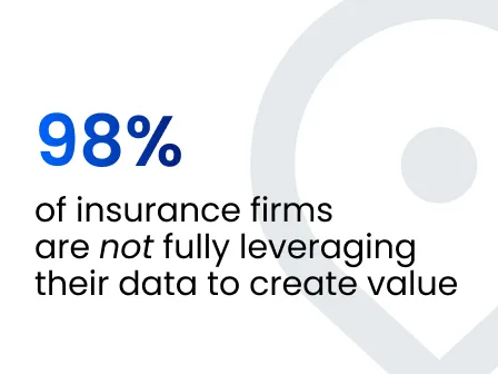
A study from 2023 showed that only 2% of UK insurance firms are fully leveraging their data to create business value, while 73% of respondents were fewer than 2 years into their digital transformation journeys.
Here's what you can expect to find in this blog:
- Start with the address. It's your root data point.
- Why ZIP Codes are failing fire underwriting
- Storm surge, elevation, and the real cost of fuzzy data
- Even auto insurance isn’t safe from bad address data
- The financial impact of bad data
- Fix it with Smarty
Start with the address. It’s your root data point.
Everything flows from the address. But too often, address data is the weak link.
Take a common error: a customer enters “10760 Hobbit CIR APT 207, Orlando, FL 32836.” That omission can break risk models, mailings, fraud checks, and internal synchronization.
In fact, incomplete or missing secondary information is a reason that claims are denied or significantly delayed, leading to unhappy customers and a damaged reputation. More importantly, though, not being able to identify the exact subunit can cause issues for underwriting and risk modeling.
Autocompletion tools like Smarty’s US Address Autocomplete or International Autocomplete prevent bad inputs before they hit your systems, whether the information is being entered by a customer or by your internal teams. These tools suggest only real, fully formed addresses, including sub-units and secondaries.
Clean address data supports:
- Correct property identification, especially with multi-unit structures and rural addresses, where the structure may be on the corner of a piece of land rather than at the center
- Accurate property application form pre-fill. Accurate address data makes it much easier to assign the correct data to each address.
- Reliable syncing across systems, keeping duplicates out and aliases aligned with the most up-to-date, standardized version of an address.
Systems using SmartyKey®, a persistent, unique identifier, can link the same address across underwriting, quoting, claims, and reinsurance models, even if the format and abbreviations shift across user inputs.
If you are unfamiliar with PUIDs, you can read about them here, but the long and the short of it is that PUIDs are numerical codes assigned to addresses that remain constant regardless of street name or ZIP Code changes over time. It also assists in eliminating duplicate records and merging alias locations across disparate sources.
Geocoding isn’t just for maps and routing (although it’s a plus).
Every geocoding subscription ought to include address verification. This means that, alongside receiving a geocode for each address you query, you should also obtain the verified and standardized versions of those addresses.
The integration of address verification with geocoding offers benefits beyond mere cost savings associated with a single product. This synergy guarantees that your geocodes and address enrichment attributes relate accurately to the correct addresses.
Pair both address geocoding and verification with enrichment—property details, elevation, build type, and more—and you’ve got the foundation for consistent, trustworthy decisions.
Why ZIP Codes are failing fire underwriting

ZIP Codes were made for mail, not for modeling wildfire exposure.
Using them to assess risk is like saying every home in Texas shares the same fire risk. It doesn’t work that way, and here’s why.
For example, let’s say a ZIP Code spans a city and the nearby foothills. If wildfire strikes the hillside, the downtown condos may be fine as heat rises and wind carries fire upwards away from them. But if your risk model prices the condos at the top of the hill the same as the ones at the bottom, you’ve either underpriced or overpriced coverage for those properties and customers.
The 2025 fires in Los Angeles exposed that exact problem. Had rooftop geocoding been standard practice, insurers could have more precisely assessed risk exposure. Properties at the edge of burn zones might’ve received appropriate coverage, but many didn’t. A geocode with rooftop-level accuracy can solve this problem as insurers can truly understand the accuracy level and price coverage appropriately.
Pairing rooftop geocodes with property enrichment, elevation data, and PUIDs is what allows insurers to identify high-risk properties more exactly, avoid overexposing a ZIP Code to risk, and more accurately price policies fairly and sustainably.
Storm surge, elevation, and the real cost of fuzzy data
Coastal properties face enormous risk from hurricanes and storm surge, yet many underwriting models still rely on ZIP Code-level data accuracy.
As an insurer, you know that a home 500 yards inland at 20 feet above sea level isn’t facing the same flood risk as one on the beachfront at 30 feet. They have the same ZIP Code, but vastly different exposure.
What you may not know is how many policies in your current book of business are harboring more risk than you're willing to accept. If you're depending solely on ZIP Code data, your loss ratio might not stand up to the next catastrophic storm.
There’s a better way.
Rooftop geocoding paired with property data, such as structure elevation, distance to body of water, and construction type, can help you and your teams discover those blind spots, and help you address them in both your current book of business and your new business.
With verified address and property data:
- You can model storm surge exposure more accurately, reducing underinsurance pains for you and your customers.
- You can verify customer-provided information during quoting, so that your premiums more accurately reflect the risk.
- You can avoid putting two very different risks into one broad risk model.
The better your data, the more exact you can be in writing your policies, and the more solvent your programs will remain, even after a big one hits.
Even auto insurance isn’t safe from bad address data

Auto underwriters understand that a lot goes into risk modeling: vehicle type, mileage, and driver behavior. But location matters, too.
Think about two identical Corvettes:
- One is parked on a downtown street in a high-theft area.
- The other sits behind security gates on a hill and in a garage.
Same ZIP Code. Different realities. Different exposure.
Without rooftop-level precision and enriched location data—garage vs. carport, driveway type, fence or fence area—those Corvettes could be assigned the same premium.
Using third-party verified address and property data tied to a PUID gives you that locational nuance. You’re not just pricing by ZIP Code; you're pricing by real-world exposure.
That’s a win for profitability and policyholder fairness.
The financial impact of bad data
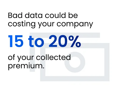
Bad data could be costing your company 15 to 20% of your collected premium. On a $1 billion book of business, that’s $150 to $200 million of missed opportunity or mispriced risk.
No one can afford that drag.
Fix it with Smarty
We’ve built tools to tackle this exact problem:
- Rooftop geocoding: Real rooftop coordinates. Not parcel centroids. Try US Rooftop Geocoding, US Reverse Geocoding, or QGIS Geocoding to get started!
- SmartyKey®: Persistent, stable, unique IDs for every address. Get it included with US Address Verification, International Address Verification, US Property Data, and any geocoding products previously listed.
- Property attributes: ~350 data points, from elevation and construction type to pool presence. US Property Data, US Census Block and Tract Data, and US Secondary Address Data are at your service.
- Parcel boundaries (coming soon): Unlock better spatial modeling and land-use insights.
Insurers who invest in address and property data integrity don’t just underwrite better. They avoid solvency issues, build better customer trust, and lead their market.
Ready to see what clean data looks like? Try Smarty’s tools for free today. We won’t even make you add a credit card.
Was this helpful?
