How address verification and rooftop geocoding enhance risk analysis


Address verification is an essential tool that property insurance companies should use when analyzing risk. Perils are often associated with potential hazards located on or near a property, but they can also be tied to the general area a property is in.
Verifying addresses ensures that a policy falls within a covered area, which is vital for both an insurance company and their customers.
To start, the insurance policy premium needs to be priced for the property's actual location. Otherwise, a premium could be mispriced because of a misclassified risk area.
Additionally, for a customer to buy a policy in the first place, their property’s location needs to refer to the right zone (We recently got a letter saying we’re now in a wildfire zone, guess we’re officially smokin’ hot 🤣).
For insurance companies, this information is especially important, as insuring a property in a bad area can put them at risk of being out of compliance with the Department of Insurance or lead to a greater loss in claims than previously anticipated.
While address verification is an important tool for risk analysis, it’s only part of what address data can offer. When utilized alongside rooftop geocoding, insurance companies increase the accuracy and reliability of their risk models.
Without both verification and geocoding, insurance companies are missing out on, or worse, misassigning, critical property data—such as exact coordinates of a property’s primary structure, what type of buildings are on a property, how close a structure is to potential hazards, and much more.
Let’s dive into the benefits address verification has to offer property insurance carriers and reinsurance companies, and see how rooftop geocoding can take your current risk modeling practices to the next level—we might even throw in some dad jokes along the way.
Analyzing risk models with address verification & property data
Address verification has a lot to offer property insurance carriers. Verification can improve the accuracy of addresses provided by policyholders. It confirms that an address is deliverable, sending mailed documents and notices to reach policyholders on time, the first time.
Address verification standardizes addresses to adhere to the rules of the local postal authority and corrects formatting issues within a database. This boosts data quality, which is key to creating a high level of confidence in a risk analysis.
Verification also prevents multiple addresses or records for the same customer from entering databases. This contributes to an increased understanding of where customers are located while simultaneously preventing inflated demographic info.
But Smarty® has another tool to assist you with boosting risk analysis accuracy.
US Property Data is full of property location attributes, like structure elevation and parcel level, and property structure attributes, such as square footage, roof material and type, and construction type. Additionally, property data returns financial data points—tax history, prior sale amount, property ownership, and much more.
With geocoding and verification, you’ll ensure that these attributes are connected to a real address and structure-specific coordinates. We were going to add a joke about latitude and longitude here, but they said it lacked direction. 🙈
Add in Smarty’s US Property Data, which has over 350 property data points, and you’ll have the most accurate risk models around (and an ROI that can beat up your competitor’s ROIs.) Want to see property data in action? Go ahead and try it out!
Enhancing risk analysis with rooftop geocoding
Let’s start with the basics. A geocode is a set of latitude and longitude coordinates that represents a specific geographic place. Geocoding is the process of transforming an address into those coordinates.
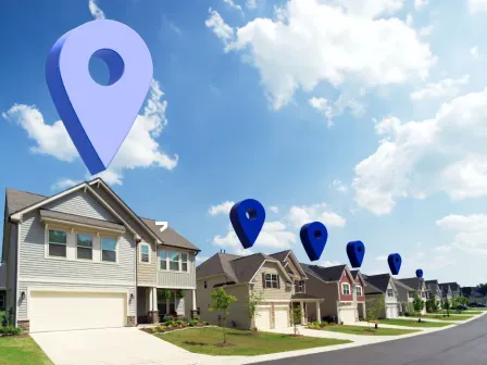
Parcel centroid geocoding takes the known boundaries of a property and approximates the geocode associated with the center of a parcel. Alternatively, rooftop geocoding ensures that the geocode identifies the rooftop of the primary structure on a parcel.
With the exact coordinates of a structure, an insurance company can identify risk factors with impressive accuracy.
In tandem with risk data—information used to assess how likely a property is to experience losses and the potential severity of those losses—geocoding can influence the analysis of hazards like:
- Wildfires: When evaluating major risk factors associated with the threat of wildfires, a structure’s exact coordinates are key. Insurance companies can measure the distance between a structure and a fuel load or vegetation burn points.
- Flood zones: In the US, 90% of natural disasters involve flooding (we tried to file a flood insurance claim the other day, but they said our jokes were already underwater.) With geocoding, determining whether a structure is within a flood zone is a breeze.
- Bodies of water: A structure’s proximity to a body of water, which is easy to assess with geocoding, can lead to a variety of risks, such as flooding caused by storm surges, coastal and cliffside erosion, and health hazards due to polluted water.
- Storm risk: Hail and wind are two of the top storm risks that affect properties. With the accurate address data provided by geocoding and historical data pertaining to past storms in an area, the risk level of a property can be meticulously calculated.
- Crime level: With pinpoint geocoding, insurance companies can find a property’s exact distance from high-crime areas and adjust premiums accordingly.
Geocoding does more than provide coordinates to calculate proximity with. It distinguishes between units within a multi-unit building. This is especially helpful when insuring multi-building lots, multi-family housing, and resort properties. In these large complexes, parcel centroid geocodes often lack the precision to make good decisions.
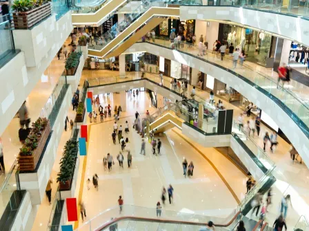
Let’s use shopping malls as an example. While the Auntie Anne’s pretzel you’re craving may come from a storefront next to a coastline, the Orange Julius Original waiting for you on the opposite side of the mall could be a half mile away. A parcel centroid geocode could produce coordinates in the center of the mall for both stores, leading to miscalculations and even worse risk assessments.
With rooftop geocoding, the property risk of both Auntie Anne’s and Orange Julius would be assessed with greater accuracy. Because of that, clients are happy knowing that all their mall food court dreams are fully and fairly insured.
For multi-unit lots, geocoding can also inform insurance companies which vendors surround a property. When certain types of businesses are nested together, risk can be impacted, making this information important for risk analysis.
Rooftop geocoding isn’t just helpful for properties often found in cities.
In rural areas, parcels are frequently large or irregular. For these properties, parcel centroid geocodes can be far from the primary structure. This can lead to inaccurate risk modeling when it comes to proximity to risk factors—a mistake prevented by rooftop geocoding.
Additional address data tools for risk analysis
In addition to address verification and rooftop geocoding, metadata that’s returned with these lookups can boost the accuracy of risk analysis.
One especially helpful data point that’s already included with Smarty’s US Rooftop Geocoding and US Address Validation is SmartyKey®. And don’t worry, this key won't get lost in the couch cushions along with $2.39, a half-eaten Cheeto, and your favorite sock.
SmartyKey is a persistent unique identifier (PUID). To ensure the consistency of datasets, each address is assigned a PUID that will remain unchanged, even if other components of that address change.
These components include ZIP+4 codes, which change for 5% of all addresses each month, and street names, which can be renamed by city or county councils after an ordinance is approved. We’d suggest Big Foot Road or Gravy Train Lane, but they’re already taken.
For example, Cougar Boulevard has been referred to by several names, including 1230 N and Bulldog Boulevard. A single property on this street could be referred to using three different addresses. If instances of all three addresses occur in a database, their consistent SmartyKey would effectively help you merge the duplicates, keeping your dataset clean.
We like our datasets like our kitchen fridge, with no expired leftovers. Clean data becomes particularly important when blending data sets by address, and is one of the main reasons companies require address verification.
By assigning data to a SmartyKey rather than an address, blended data has fewer formatting errors, typos, and parsing complications. It also becomes easier to connect different aspects of address data, such as property attributes, risk models, and insured addresses.
What’s more, there’s an additional layer of privacy added when data is identified with a PUID, rather than an address. A customer’s address qualifies as Personally Identifiable Information (PII), meaning that every address in your database increases your chances of liability.
With SmartyKey, address data becomes safer for insurance companies and their customers. The randomly generated PUIDs can’t be reverse-engineered, meaning an address, or any other piece of PII tied to a SmartyKey, can’t be identified from a key alone.
SmartyKey also reduces processing time when blending address data. As a 10-digit integer, it has significantly compact storage, which can save software engineers up to 20 hours when blending data. (Why did the software engineer go broke? He used up all his cache because he didn’t have a SmartyKey! 😆)
If your current address data tools aren’t improving your ability to blend data, it’s time for an upgrade. Take US Rooftop Geocoding for a spin to see SmartyKey in action.
Conclusion
If the geocoding tools you’re relying on don’t have the ability to verify and standardize addresses, provide datapoints beyond the address for more informed risk modeling, identify alias locations and deduplicate messy aggregate data, or put a pin on the roof of the place you’re insuring, they’re not providing you with the most accurate information available.
You know that reliable address data is essential for property insurance companies, so don’t sell yourself short; find a new provider. You deserve an upgrade!
Our US Rooftop Geocoding has all the capabilities of our US Address Verification or International Address Verification, and, to top it off, provides the rooftop-accurate geocodes you need.
We’ll ensure all your addresses are valid, formatted correctly, and returned with pinpoint coordinates that locate the primary structure, not just the center of a property.
By boosting the accuracy of property data and the risk analysis that relies on it, geocoding will improve your company’s ability to analyze risk, making you and your customers more confident in your assessments and policies.
Was this helpful?
